 W
WThe Juan Amarillo, Arzobispo, or Salitre River is a river on the Bogotá savanna and a left tributary of the Bogotá River in Colombia. The river originates from various quebradas in the Eastern Hills and flows into the Bogotá River at the largest of the wetlands of Bogotá, Tibabuyes, also called Juan Amarillo Wetland. The total surface area of the Juan Amarillo basin, covering the localities Usaquén, Chapinero, Santa Fe, Suba, Barrios Unidos, Teusaquillo, and Engativá, is 12,892 hectares. Together with the Fucha and Tunjuelo Rivers, the Juan Amarillo River forms part of the left tributaries of the Bogotá River in the Colombian capital.
 W
WThe Bogotá Fault is a major inactive slightly dextral oblique thrust fault in the department of Cundinamarca in central Colombia. The fault has a total length of 79.3 kilometres (49.3 mi), while other authors designate a length of 107 kilometres (66 mi), and runs along an average north-northeast to south-southwest strike of 013.5 ± 7 across the Altiplano Cundiboyacense, central part of the Eastern Ranges of the Colombian Andes.
 W
WThe Bogotá River is a major river of the Cundinamarca department of Colombia, crossing the region from the northeast to the southwest and passing along the western limits of Bogotá. The large population and major industrial base in its watershed have resulted in extremely severe pollution problems for the river.
 W
WThe Bogotá savanna is a montane savanna, located in the southwestern part of the Altiplano Cundiboyacense in the center of Colombia. The Bogotá savanna has an extent of 4,251.6 square kilometres (1,641.6 sq mi) and an average altitude of 2,550 metres (8,370 ft). The savanna is situated in the Eastern Ranges of the Colombian Andes.
 W
WThe Eastern Hills are a chain of hills forming the eastern natural boundary of the Colombian capital Bogotá. They are part of the Altiplano Cundiboyacense, the high plateau of the Eastern Ranges of the Colombian Andes. The Eastern Hills are bordered by the Chingaza National Natural Park to the east, the Bogotá savanna to the west and north, and the Sumapaz Páramo to the south. The north-northeast to south-southwest trending mountain chain is 52 kilometres (32 mi) long and its width varies from 0.4 to 8 kilometres. The highest hilltops rise to 3,600 metres (11,800 ft) over the western flatlands at 2,600 metres (8,500 ft). The Torca River at the border with Chía in the north, the boquerón Chipaque to the south and the valley of the Teusacá River to the east are the hydrographic limits of the Eastern Hills.
 W
WThe Bogotá Formation (Spanish: Formación Bogotá, E1-2b, Tpb, Pgb) is a geological formation of the Eastern Hills and Bogotá savanna on the Altiplano Cundiboyacense, Eastern Ranges of the Colombian Andes. The predominantly shale and siltstone formation, with sandstone beds intercalated, dates to the Paleogene period; Upper Paleocene to Lower Eocene epochs, with an age range of 61.66 to 52.5 Ma, spanning the Paleocene–Eocene Thermal Maximum. The thickness of the Bogotá Formation ranges from 169 metres (554 ft) near Tunja to 1,415 metres (4,642 ft) near Bogotá. Fossils of the ungulate Etayoa bacatensis have been found in the Bogotá Formation, as well as numerous reptiles, unnamed as of 2017.
 W
WThe Chipaque Formation (Spanish: Formación Chipaque, K2cp, Kc) is a geological formation of the Altiplano Cundiboyacense, Eastern Ranges of the Colombian Andes. The formation is also described as Gachetá Formation, named after Gachetá, in the area of the Llanos foothills of the Eastern Ranges. The predominantly organic shale formation dates to the Late Cretaceous period; Cenomanian-Turonian epochs and has a maximum thickness of 1,700 metres (5,600 ft). The formation, rich in TOC, is an important oil and gas generating unit for the giant oilfields Cupiagua and Cusiana of the Eastern Ranges as well as in the Llanos Orientales.
 W
WThe Guaduas Formation (Spanish: Formación Guaduas, K2P1G, K2E1G, KPgg, KTg, TKg, Ktg) is a geological formation of the Middle Magdalena Basin and the Altiplano Cundiboyacense, Eastern Ranges of the Colombian Andes. The predominantly shale with coalbed formation dates to the Late Cretaceous and Paleogene periods; Maastrichtian-Paleocene epochs, and has a maximum thickness of 1,090 metres (3,580 ft). Fossils of Coussapoa camargoi, Ficus andrewsi, Berhamniphyllum sp. and Archaeopaliurus boyacensis have been found in coalbeds in Zipaquirá and Tasco, Boyacá.
 W
WThe Usme Formation is a geological formation of the Bogotá savanna, Altiplano Cundiboyacense, Eastern Ranges of the Colombian Andes. The formation consists of a lower part with predominantly shales with intercalated sandstone beds and an upper sequence with sandstones and conglomerates. The Usme Formation dates to the Neogene and Paleogene periods; Late Eocene to Early Oligocene epochs, and has a maximum thickness of 300 metres (980 ft).
 W
WThe Fucha River is a river on the Bogotá savanna and a left tributary of the Bogotá River. The river originates in the Eastern Hills of the Colombian capital Bogotá and flows westward through the city into the Bogotá River. It is one of the three important rivers of the city, together with the Tunjuelo and Juan Amarillo Rivers.
 W
WThe Guadalupe Group (Spanish: Grupo Guadalupe, K2G, Ksg) is a geological group of the Altiplano Cundiboyacense, Eastern Ranges of the Colombian Andes. The group, a sequence of shales and sandstones, is subdivided into three formations; Arenisca Dura, Plaeners and Arenisca Labor-Tierna, and dates to the Late Cretaceous period; Campanian-Maastrichtian epochs and at its type section has a thickness of 750 metres (2,460 ft).
WGuadalupe Hill is a 3,360-metre (11,020 ft) high hill located in the Eastern Hills, uphill from the centre of Bogotá, Colombia. Together with its neighbouring hill Monserrate it is one of the landmarks of Bogotá. At the top of the hill a hermitage and a 15-metre (49 ft) high statue has been erected. The statue was elaborated by sculptor Gustavo Arcila Uribe in 1946 and is accompanied by a chapel dedicated to Our Lady of Guadalupe.
 W
WMetropolitan Area of Bogotá is the metropolitan area of the Colombian capital city of Bogotá, usually used for statistical analysis or technical use.
 W
WMonserrate is a high Mountain over 10,000 feet high that dominates the city center of Bogotá, the capital city of Colombia. It rises to 3,152 meters (10,341 ft) above the sea level, where there is a church with a shrine, devoted to El Señor Caído.
WThe Regadera Formation (Spanish: Formación Regadera, E2r, Tpr) is a geological formation of the Bogotá savanna, Altiplano Cundiboyacense, Eastern Ranges of the Colombian Andes. The predominantly sandstone and conglomeratic formation, with pink shale beds intercalated, dates to the Paleogene period; Middle to Late Eocene epoch, and has a maximum thickness of 765 metres (2,510 ft).
 W
WThe Sabana Formation is a geological formation of the Bogotá savanna, Altiplano Cundiboyacense, Eastern Ranges of the Colombian Andes. The formation consists mainly of shales with at the edges of the Bogotá savanna lignites and sandstones. The Sabana Formation dates to the Quaternary period; Middle to Late Pleistocene epoch, and has a maximum thickness of 320 metres (1,050 ft), varying greatly across the savanna. It is the uppermost formation of the lacustrine and fluvio-glacial sediments of paleolake Humboldt, that existed at the edge of the Eastern Hills until the latest Pleistocene.
WThe Subachoque Formation is a geological formation of the Bogotá savanna, Altiplano Cundiboyacense, Eastern Ranges of the Colombian Andes. The formation consists mainly of sandy shales and lignite with sandstone beds. The Subachoque Formation dates to the Quaternary period; Early to Middle Pleistocene epoch, and has a maximum thickness of 150 metres (490 ft). It is the lowermost formation of the lacustrine and fluvio-glacial sediments of Lake Humboldt.
 W
WThe Sumapaz River is a major tributary of the Magdalena River in Colombia. The 95 kilometres (59 mi) long river originates in the Eastern Ranges of the Colombian Andes at the largest páramo in the world; Sumapaz, of which it takes its name. It forms the natural boundary between the departments of Cundinamarca and Tolima.
 W
WThe Chibcha Terrane, named after Chibcha, is the largest of the geological provinces (terranes) of Colombia. The terrane, the oldest explored domains of which date to the Meso- to Neoproterozoic, is situated on the North Andes Plate. The megaregional Romeral Fault System forms the contact of the terrane with the Tahamí Terrane. The contact with the Caribbean and La Guajira Terranes is formed by the regional Bucaramanga-Santa Marta Fault. The northeastern boundary is formed by the regional Oca Fault, bounding the La Guajira Terrane. The terrane is emplaced over the Río Negro-Juruena Province of the Amazonian Craton along the megaregional Eastern Frontal Fault System.
 W
WThe Teusacá River is a river in the Eastern Hills of Bogotá and on the Bogotá savanna. It is a left tributary of the Bogotá River, Colombia. The river of 69 kilometres (43 mi) long originates at an altitude of 3,560 metres (11,680 ft) at the Alto Los Tunjos, Santa Fe, and flows northward through the municipalities La Calera, Guasca, Sopó, to flow into the Bogotá River in Cajicá at an altitude of 2,554 metres (8,379 ft). The upper part of the Teusacá River basin has a páramo ecosystem with the páramos of Chingaza, El Verjón and Cruz Verde surrounding the river. The San Rafael Reservoir in La Calera, important water source for the Colombian capital, is sourced by the Teusacá River.
 W
WThe Thomas van der Hammen Natural Reserve or Thomas van der Hammen Forest Reserve is an area of the Bogotá savanna that is under environmental protection. The natural reserve was declared as such in year 2000 by the Ministry of Environment and Sustainable development. It takes its name from the Dutch-Colombian geologist Thomas van der Hammen who devoted his life to the research of the region. The surface area of the protected reserve is approximately 1,395 hectares and it is located in the north of Bogotá.
 W
WThe Torca River is a river on the Bogotá savanna and a left tributary of the Bogotá River. The river, in a basin of 6,008.69 hectares (23.1997 sq mi), originates in the Eastern Hills of Bogotá at an altitude of 2,837 metres (9,308 ft). It flows in the north of the Colombian capital, through the locality of Usaquén and into the Bogotá River in Suba at the border with Chía, at 2,545 metres (8,350 ft) above sea level. The Torca wetland is located near its mouth.
WThe Tunjuelo Formation, Río Tunjuelo or Río Tunjuelito Formation is a geological formation of the Bogotá savanna, Altiplano Cundiboyacense, Eastern Ranges of the Colombian Andes. The formation consists mainly of conglomerates with intercalating shales and sandstones. The Tunjuelo Formation dates to the Quaternary period; covering the complete Pleistocene epoch, and has a maximum thickness of 150 metres (490 ft). It is a formation of the lacustrine and fluvio-glacial sediments of Lake Humboldt.
 W
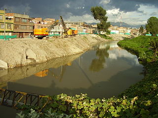
WThe Tunjuelo or Tunjuelito River is a river on the Bogotá savanna and a left tributary of the Bogotá River. The river, with a length of 73 kilometres (45 mi) originates in the Sumapaz Páramo and flows northward through the Usme Synclinal to enter the Colombian capital Bogotá. There, the river is mostly canalised flowing westward into the Bogotá River. It is one of the three main rivers of the city, together with the Fucha and Juan Amarillo Rivers.
 W
WUrban water management in Bogotá, a metropolitan area of more than 8 million inhabitants, faces three main challenges: improving the quality of the highly polluted Bogotá River, controlling floods and revitalizing riparian areas along the river. The main public entities in charge of water resources management in Bogotá are the district government, the regional environmental agency Corporación Autónoma Regional (CAR) of the department of Cundinamarca, and the water and sanitation utility Empresa de Acueducto y Alcantarillado de Bogotá (EAAB). A court mandated that these entities cooperate to improve the river's quality, a ruling that translated into an agreement signed in 2007 that defined the responsibilities of each entity and forced them to approach the water management challenges in an integrated way. The agreement prepared the ground for the expansion of the Salitre wastewater treatment plant, construction of a new one, widening and protecting of riparian zones, restoring the natural meander of the river, and hydraulically connecting the river to its flood plains. These measures are supported by the World Bank and the Inter-American Development Bank.