 W
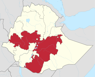
WThe Oromia Region is a regional state in Ethiopia, the homeland of the Oromo people. It is bordered by the Somali Region to the east; the Amhara Region, the Afar Region and the Benishangul-Gumuz Region to the north; Dire Dawa to the northeast; the South Sudanese state of Upper Nile, Gambela Region, Southern Nations, Nationalities, and Peoples' Region and Sidama Region to the west; the Eastern Province of Kenya to the south; as well as Addis Ababa as an enclave surrounded by Oromia Special Zone Surrounding Finfinne in its center and the Harari Region as an enclave surrounded by East Hararghe in its east. The 2011 census reported the population of Oromia as 35,000,000; this makes it the largest regional state in population. It is also the largest regional state covering 286,612 square kilometers. Oromia is the world's forty-second most populous subnational entity, and the most populous subnational entity in all of Africa.
 W
WLake Abijatta is an alkaline lake in Ethiopia. It lies in the Main Ethiopian Rift valley south of Addis Ababa, in the Abijatta-Shalla National Park.
 W
WAbijatta-Shalla National Park is a national park in Ethiopia. It is located in the Oromia Region and the Ethiopian Highlands region, 200 kilometers south of Addis Ababa, and east of the Ziway–Shashamane highway.
WAbul Kasim is a mountain in southeastern Ethiopia. Located in the Arsi Zone of the Oromia Region, this mountain has an elevation of 2,573 metres (8,442 ft) above sea level. It is the highest point in Seru woreda.
 W
WThe Ahmar Mountains is a mountain range of the Ethiopian Highlands, located in the eastern Oromia Region and Somali Region of Ethiopia.
 W
WThe Bale Mountains, in the Oromia Region of southeast Ethiopia, south of the Awash River, are part of the Ethiopian Highlands. They include Tullu Demtu, the second-highest mountain in Ethiopia, and Mount Batu. The Weyib River, a tributary of the Jubba River, rises in these mountains east of Goba. The Bale Mountains National Park covers 2,200 square kilometers of these mountains. The main attractions of the park are the wild alpine scenery, and the relative ease with which visitors can see unique birds and mammals.
 W
WBale Mountains National Park (BMNP) is a national park in Ethiopia. The park encompasses an area of approximately 2,150 square kilometres in the Bale Mountains and Sanetti Plateau of the Ethiopian Highlands.
 W
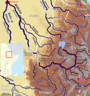
WThe Baro River is a river in southwestern Ethiopia, which defines part of Ethiopia's border with South Sudan. From its source in the Ethiopian Highlands it flows west for 306 kilometres (190 mi) to join the Pibor River. The Baro-Pibor confluence marks the beginning of the Sobat River, a tributary of the White Nile.
WMount Chilalo is an isolated, extinct silicic volcanic mountain in southeastern Ethiopia. Its highest point, in the Arsi Zone of the Oromia Region, is located on the border between the Hitosa and Tiyo woreda.
 W
WThe Dabus River is a north-flowing tributary of the Abay River in southwestern Ethiopia; it joins its parent stream at 10°36′38″N 35°8′58″E. The Dabus has a drainage area of about 21,032 square kilometers.
 W
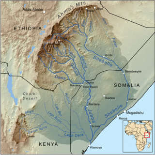
WThe Dawa River is found in East Africa, covering an area of, 58,961km2. It flows through three major countries: Kenya, Ethiopia, and Somalia, with 81% falling into Ethiopian territory. It is known for its complex geological environment, evident through its diverse lithology and structural framework, coming from the river’s closeness to multiple volcanic-tectonic events. The wide river has gentle slopes either side of its exposed bedrock. The Dawa river flows south east to form part of the Ethiopia - Somalia border and part of Ethiopia - Kenya border. Awata, Digati, and Mormora are the only significant off-flowing rivers to Dawa.
WThe Didessa River is a river in western Ethiopia. A tributary of the Abay River, it rises in the mountains of Gomma, flowing in a northwestern direction to its confluence where the course of the Abay has curved to its southernmost point before turning northwards at about 9°57′N 35°41′E. The Didessa's drainage area is about 19,630 square kilometers, covering portions of the Benishangul-Gumuz Region and the West Welega Zone of the Oromia Region.
 W
WThe Ethiopian Highlands is a rugged mass of mountains in Ethiopia, situated in northeast part of Africa. It forms the largest continuous area of its elevation in the continent, with little of its surface falling below 1,500 m (4,900 ft), while the summits reach heights of up to 4,550 m (14,930 ft). It is sometimes called the Roof of Africa due to its height and large area. Most of the Ethiopian Highlands are part of central and northern Ethiopia, and its northernmost portion reaches into Eritrea.
WThe Ganale Doria River is a perennial river in southeastern Ethiopia. Rising in the mountains east of Aleta Wendo, the Ganale flows south and east to join with the Dawa at the border with Somalia to become the Jubba. The river's tributaries include the Welmel, Weyib, Dumale, Doya, Hawas and the Hambala. The Del Verme Falls is a notable feature of its middle course.
 W
WThe Gebba is a river of southwestern Ethiopia. It is a tributary of the Baro River, which is created when the Gebba joins the Birbir at latitude and longitude 8°14′28″N 34°57′39″E. The river is the planned site for the twin Gebba Hydro electric power dams.
 W
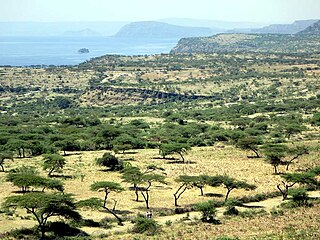
WThe Harenna Forest is located in a highland forest region of the Bale Mountains, in the Oromia Region of southeastern Ethiopia.
 W
WLake Basaka is a shallow, saline lake in the Oromia Region of central Ethiopia. It is located in the Great Rift Valley about 200 kilometres (120 mi) south east of the capital Addis Ababa. The lake is at an elevation of 950 metres (3,000 ft).
 W
WLake Shala is an alkaline lake located in the Ethiopian Rift Valley, in the Abijatta-Shalla National Park.
 W
WFentale is a stratovolcano located in the Oromia Region, Ethiopia. It is the highest point of Fentale woreda.
WTullu Dimtu is the fourth highest peak in Ethiopia after Ras Dashen (4550m), Ancua (4462m), and Kidus Yared (4453m).
WMount Welel is a mountain in southwestern Ethiopia. Located in the Mirab Welega Zone of the Oromia Region, it has an elevation of 3,301 metres (10,830 ft) above sea level. Characterized by twin peaks, Welel is the highest point in the Zone and Hawa Welele woreda.
WThe Muger River is a north-flowing tributary of the Abay River in central Ethiopia, which is notable for its deep gorge. Its confluence with the Abay is at: 9°55′07″N 37°55′50″E. Tributaries of the Muger include the Labbu. The Muger has a drainage area of about 8,188 square kilometers.
 W
WThe Sanetti Plateau is a major plateau landform of the Ethiopian Highlands, located in the Oromia Region of Ethiopia
WThe Bale Mountains, in the Oromia Region of southeast Ethiopia, south of the Awash River, are part of the Ethiopian Highlands. They include Tullu Demtu, the second-highest mountain in Ethiopia, and Mount Batu. The Weyib River, a tributary of the Jubba River, rises in these mountains east of Goba. The Bale Mountains National Park covers 2,200 square kilometers of these mountains. The main attractions of the park are the wild alpine scenery, and the relative ease with which visitors can see unique birds and mammals.
WWeyib River is a river of eastern Ethiopia. It rises in the Bale Mountains east of Goba in the Oromia Region, flowing east to pass through the Sof Omar Caves, then to the southeast until it joins the Ganale Dorya River in the Somali Region.