 W
WThe Acari River is located in Rio de Janeiro state in southeastern Brazil. It is one of the major watercourses of the city of Rio de Janeiro.
 W
WBuraco do Padre is a region of Parana, but not officially recognized as a neighborhood. Next big city is Ponta Grossa.
 W
WThe Campo de Santana is a park located in the Praça da República in downtown Rio de Janeiro, Brazil. The name of the plaza refers to the fact that it is located near the site where the Brazil was declared a Republic in 1889.
 W
WCorcovado, which means "hunchback" in Portuguese, is a mountain in central Rio de Janeiro, Brazil. It is a 710-metre (2,329 ft) granite peak located in the Tijuca Forest, a national park.
 W
WFavela Santa Marta is a favela located in the Botafogo and Laranjeiras part of the Morro Dona Marta, that is also divided with the neighborhoods of Flamengo, Cosme Velho and Silvestre, in the South Zone of Rio de Janeiro, Brazil. It has about 8000 residents, with 500 wooden houses, 2000 brick houses, 4 kindergartens, 3 bakeries, 2 sports fields, 1 block of a samba school, 3 military units and 1 small market. The favela is one of the steepest in the city.
 W
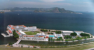
WGovernador Island is the largest island in Guanabara Bay, in Rio de Janeiro, Brazil. It has a population of about 211,018 inhabitants, in a small area of 42 km2 (16 sq mi).
 W
WGuanabara Bay is an oceanic bay located in Southeast Brazil in the state of Rio de Janeiro. On its western shore lies the cities of Rio de Janeiro and Duque de Caxias, and on its eastern shore the cities of Niterói and São Gonçalo. Four other municipalities surround the bay's shores. Guanabara Bay is the second largest bay in area in Brazil, at 412 square kilometres (159 sq mi), with a perimeter of 143 kilometres (89 mi).
 W
WIlha das Cobras is an island located within Guanabara Bay in the city and state of Rio de Janeiro, Brazil. It is east of the neighborhood Guanabara. It is home to the Arsenal de Marinha do Rio de Janeiro base of the Brazilian Navy.
 W
WIlha Fiscal is an island in Guanabara Bay, bordering the historic city center of Rio de Janeiro, in southeastern Brazil.
 W
WThe Ilhas Cagarras are an uninhabited archipelago located 5 km off Ipanema, a major beach of the southern coast of the city of Rio de Janeiro, Brazil. They have been designated a federal natural monument since 2010.
 W
WLargo do Machado is a square located on the border of the Catete, Flamengo and Laranjeiras neighborhoods in the city of Rio de Janeiro, Brazil.
 W
WThe Maracanã River of Rio de Janeiro, which means parrot-like in Tupi–Guarani, is a river located in Rio de Janeiro state in southeastern Brazil.
 W
WThe Marapendi Natural Municipal Park is a municipal nature park, a public recreation facility of approximately 155 hectares within the Marapendi Natural Reserve, located in the Barra da Tijuca and Recreio neighborhoods of Rio de Janeiro, Brazil and part of a protected area for the preservation of native plants and animals.
 W
WThe Meriti is a river in Rio de Janeiro state in south-eastern Brazil.
 W
WThe Morro da Babilônia is a hill in the Leme neighbourhood of Rio de Janeiro, separating Copacabana beach from Botafogo. It is home to a favela known by the same name, as well as the favela Chapéu Mangueira. Morro da Babilônia is an environmentally protected area.
 W
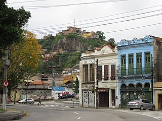
WMorro da Providência is a favela located between the two Rio de Janeiro districts of Santo Cristo and Gamboa. It has an altitude of 115 metres and is located in the port area of the city. It is widely considered to be the first favela community in Brazil."The granite hump of Providencia gazes down like a stern guardian on the old port of Rio de Janeiro. It offers probably the finest viewpoint over any city I know."
 W
WMorro dos Prazeres - "Hill of Pleasures" - is a favela in the Southern Zone, the Zona Sul of the Brazilian metropolis Rio de Janeiro. It is part of the quarter Santa Teresa, which is roughly 2.5 km northeast, and although considered pacified, has recently been the site of murders by gunshot of two tourists who inadvertently wandered into the community. "" Settlement of the Morro dos Prazeres began in 1940 and the census of 2010 suggested a population of 2136 people. The mountain, respectively hill, the favela is named after has an altitude of 275 metres.
 W
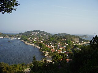
WPaquetá Island is an island in Guanabara Bay, Rio de Janeiro. The name of the island is a Tupi word meaning "many pacas". The island is an auto-free zone, so travel is limited to bicycles and horse-drawn carriages. Paquetá has twenty baobabs, the only ones in Brazil beside the Baobá in Passeio Público. One of the trees is called "Maria Gorda", which residents kiss for luck.
 W
WPedra da Gávea is a monolithic mountain in Tijuca Forest, Rio de Janeiro, Brazil. Composed of granite and gneiss, its elevation is 844 metres (2,769 ft), making it one of the highest mountains in the world that ends directly in the ocean. Trails on the mountain were opened up by the local farming population in the early 1800s; today, the site is under the administration of the Tijuca National Park.
 W
WThe Marapendi Natural Reserve is a coastal nature preserve of approximately 665.62 hectares, located in the Barra da Tijuca and Recreio neighborhoods of Rio de Janeiro, Brazil, established for the preservation of native plants and animals such as the Paraná and jacarandas pines, restinga, mangroves and the Channel-billed toucan.
 W
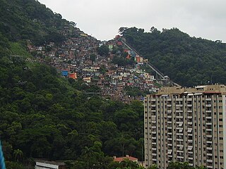
WRocinha is the largest favela in Brazil, located in Rio de Janeiro's South Zone between the districts of São Conrado and Gávea. Rocinha is built on a steep hillside overlooking Rio de Janeiro, and is located about one kilometre from a nearby beach. Most of the favela is on a very steep hill, with many trees surrounding it. Around 100,000 people live in Rocinha, making it the most populous favela in Brazil.
 W
WRodrigo de Freitas Lagoon is a lagoon in the district of Lagoa in the Zona Sul area of Rio de Janeiro. The lagoon is connected to the Atlantic Ocean, allowing sea water to enter by a canal along the edge of a park locally known as Jardim de Alah.
 W
WSugarloaf Mountain is a peak situated in Rio de Janeiro, Brazil, at the mouth of Guanabara Bay on a peninsula that juts out into the Atlantic Ocean. Rising 396 m (1,299 ft) above the harbor, its name is said to refer to its resemblance to the traditional shape of concentrated refined loaf sugar. It is known worldwide for its cableway and panoramic views of the city and beyond.
 W
WVillegagnon Island is located near the mouth of the large Guanabara Bay, in the city of Rio de Janeiro, Brazil.
 W
WThe Vista Chinesa is one of the belvederes of Rio de Janeiro, at the topmost of one of the roads that connect the Jardim Botânico area to the Parque Nacional & Floresta da Tijuca, known as the Estrada da Vista Chinesa.