 W
WCerro Bravo is a stratovolcano located in Tolima, Colombia, north of the Nevado del Ruiz volcano. The rock type of the volcano is andesite.
 W
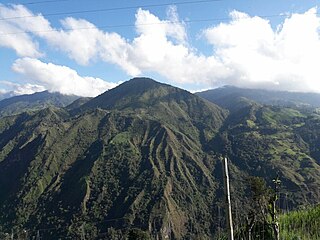
WCerro Machín is a stratovolcano located in Tolima Department, Colombia. Cerro Machin is a volcanic plug that is approximately the same age as the Ruiz-Tolima Massif and has the appearance of being part of that volcanic system. Its sisters are Nevado del Tolima, 17,060 feet (5,200 m); Santa Isabel, 16,240 feet (4,950 m), Nevado del Ruiz, 17,457 feet (5,321 m), plus nine other lesser volcanoes and a 10,000 feet (3,000 m) volcanic South Wall containing in excess of thirty volcanic domes.
 W
WThe Cucuana Fault is a dextral strike-slip fault in the departments of Tolima and Cundinamarca in Colombia. The fault has a total length of 141.4 kilometres (87.9 mi) and runs along an average east-northeast to west-southwest strike of 067.9 ± 6 crossing the Middle Magdalena Valley from the Central towards the Eastern Ranges of the Colombian Andes.
WThe Honda Fault (Spanish: Falla de Honda is a reverse sinistral oblique strike-slip fault in the departments of Tolima, Caldas and Cundinamarca in central Colombia. The fault has a total length of 187.3 kilometres and runs along an average north-northeast to south-southwest strike of 016.6 ± 12 in the Middle Magdalena Valley.
WThe Ibagué Fault is a major dextral slightly oblique strike-slip fault in the department of Tolima in central Colombia. The fault has a total length of 123.9 kilometres (77.0 mi) and runs along an average east-northeast to west-southwest strike of 067.9 ± 11 cross-cutting the Central Ranges of the Colombian Andes.
WLa Dina Fault is a regional dextral oblique thrust fault in the departments of Huila and Tolima in southwestern Colombia. The fault has a total length of 206.9 kilometres (128.6 mi) and runs along an average northeast to southwest strike of 032.9 ± 13 in the Upper Magdalena Valley and the Central Ranges of the Colombian Andes.
WThe Mulato-Getudo or Mulato-Jetudo Fault is a sinistral oblique thrust fault in the departments of Tolima, Caldas and Antioquia in central Colombia. The fault has a total length of 187.3 kilometres (116.4 mi) and runs along an average north-northeast to south-southwest strike of 016.7 ± 9 in the Middle Magdalena Valley and along the western foothills of the Central Ranges of the Colombian Andes.
 W
WThe Barzalosa Formation is a fossiliferous geological formation of the Upper Magdalena Valley and the bounding foothills of the Central Ranges and Eastern Ranges of the Colombian Andes. The formation consists of conglomerates, sandstones and siltstones. The Barzalosa Formation probably dates to the Late Paleogene to Early Neogene period; Oligocene to Early Miocene epochs, and has an approximate thickness of 360 metres (1,180 ft). Fossils of Balanerodus logimus, Lophiodolodus chaparralensis, Xenastrapotherium chaparralensis, Protheosodon sp. and Proadinotherium sp. have been uncovered from the formation in Chaparral, Tolima.
 W
WThe Caballos Formation is a geological formation of the Upper Magdalena Valley (VSM), Caguán-Putumayo Basin, Central and Eastern Ranges of the Colombian Andes. The sandstone and shale formation dates to the Middle Cretaceous period; Aptian to Albian epochs and has a maximum thickness of 411 metres (1,348 ft).
WThe Hiló Formation is a geological formation of the Altiplano Cundiboyacense, Eastern Ranges of the Colombian Andes. The predominantly shale formation dates to the Middle Cretaceous period; Late Albian to Early Cenomanian epochs and has a measured thickness at its type section of 470 metres (1,540 ft). The fossiliferous formation has provided a great abundance of ammonites and other marine species.
 W
WThe Honda Group is a geological group of the Upper and Middle Magdalena Basins and the adjacent Central and Eastern Ranges of the Colombian Andes. The group, in older literature also defined as formation, is in its present-day type section in the Tatacoa Desert in the department of Huila subdivided into two main formations; La Victoria and Villavieja.
 W
WThe Hondita Formation is a fossiliferous geological formation of the Upper Magdalena Valley (VSM) and surrounding Central and Eastern Ranges of the Colombian Andes, extending from Cundinamarca in the north to Huila and easternmost Tolima in the south. The lowermost unit of the Güagüaquí Group, a sequence of sandy limestones and shales, dates to the Late Cretaceous period; Turonian epoch, and has a maximum thickness of 90 metres (300 ft).
WThe Loma Gorda Formation is a fossiliferous geological formation of the Upper Magdalena Valley (VSM) and surrounding Central and Eastern Ranges of the Colombian Andes, extending from Cundinamarca in the north to Huila and easternmost Tolima in the south. The uppermost unit of the Güagüaquí Group, a sequence of laminated siltstones and shales, dates to the Late Cretaceous period; Turonian to Coniacian epochs, and has a maximum thickness of 167 metres (548 ft).
WThe Oliní Group (Spanish: Grupo Oliní, K3k5o, K2ol, Kso) is a fossiliferous geological group of the VMM, VSM and the eastern flanks of the Central and western flanks of the Eastern Ranges of the Colombian Andes. The regional group stretches from north to south across approximately 700 kilometres (430 mi) and dates to the Late Cretaceous period; Coniacian, Santonian and Campanian epochs, and has a maximum thickness of 287 metres (942 ft). Fossils of Eonatator coellensis have been found in the unit, near Coello, Tolima.
WThe Santa Teresa Formation is a geological formation of the western Eastern Ranges of the Colombian Andes, west of the Bituima Fault, and the southern Middle Magdalena Valley. The formation spreads across the western part of Cundinamarca and the northern portion of Tolima. The formation consists of grey claystones intercalated by orange quartz siltstones and sandstones of small to conglomeratic grain size. The thickness at its type section has been measured to be 118 metres (387 ft) and a maximum thickness of 150 metres (490 ft) suggested.
 W
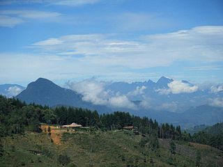
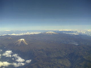
WLos Nevados National Natural Park is a national park located in the Cordillera Central of the Colombian Andes. The park sourrounds the northern volcanic complex formed by Nevado del Ruiz, Nevado del Tolima, Nevado de Santa Isabel, the paramillos of Cisne, Santa Rosa and Quindío and the Cerro Bravo and Cerro Machín.
 W
WThe Middle Magdalena Valley, Middle Magdalena Basin or Middle Magdalena Valley Basin is an intermontane basin, located in north-central Colombia between the Central and Eastern Ranges of the Andes. The basin, covering an area of 34,000 square kilometres (13,000 sq mi), is situated in the departments of Santander, Boyacá, Cundinamarca and Tolima.
 W
WNevado del Huila at 5,364 metres (17,598 ft), is the highest volcano in Colombia, located at the tripoint of the departments of Huila, Tolima and Cauca. It is visible from the city of Cali. The andesitic volcano is located on top of the Ibagué Batholith.
 W
WThe Nevado del Quindío is an inactive volcano located in the Central Cordillera of the Andes in central Colombia. The summit marks the tripoint of the departments of Risaralda, Quindío and Tolima, and is also the highest point of the departments of Risaralda and Quindío. The mountain is one of the highest peaks in the Los Nevados National Natural Park, which is a wildlife sanctuary. There are no historical records of any eruption. The andesitic volcano is located on top of the Palestina Fault.
 W
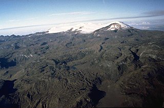
WThe Nevado del Ruiz, also known as La Mesa de Herveo is a volcano on the border of the departments of Caldas and Tolima in Colombia, about 129 kilometers (80 mi) west of the capital city Bogotá. It is a stratovolcano composed of many layers of lava alternating with hardened volcanic ash and other pyroclastic rocks. Volcanic activity at Nevado del Ruiz began about two million years ago, since the Early Pleistocene or Late Pliocene, with three major eruptive periods. The current volcanic cone formed during the present eruptive period, which began 150,000 years ago.
 W
WThe Nevado del Tolima is a Late Pleistocene to recently active andesitic stratovolcano located in the Tolima department, Colombia. The volcano lies south of Nevado del Ruiz volcano and is situated within the Los Nevados National Natural Park. The volcano, whose most recent activity dates to 1943 and last major eruption around 3600 years ago, overlies the Eocene El Bosque Batholith, dated at 49.1 ± 1.7 Ma.
WThe Nevado El Cisne is a volcano in the Central Ranges of the Andes in Colombia. Its summit is at an altitude of 4,636 metres (15,210 ft). The mountain is one of the five lava domes of the Nevado del Ruiz volcano complex. Despite the nevado part of the name, indicating a permanently snow-capped mountain, the summit of El Cisne is now below the permanent snow line as a result of global warming, and it is no longer considered a true nevado. The volcano is located over the Palestina Fault, that crosscuts the underlying El Bosque Batholith of Eocene age, dated at 49.1 ± 1.7 Ma.
 W
WSanta Isabel is a shield volcano located in Tolima, Colombia, southwest of Nevado del Ruiz volcano. The volcano is located over the Palestina Fault, that crosscuts the underlying El Bosque Batholith of Eocene age, dated at 49.1 ± 1.7 Ma.
 W
WThe Sumapaz River is a major tributary of the Magdalena River in Colombia. The 95 kilometres (59 mi) long river originates in the Eastern Ranges of the Colombian Andes at the largest páramo in the world; Sumapaz, of which it takes its name. It forms the natural boundary between the departments of Cundinamarca and Tolima.
 W
WThe Chibcha Terrane, named after Chibcha, is the largest of the geological provinces (terranes) of Colombia. The terrane, the oldest explored domains of which date to the Meso- to Neoproterozoic, is situated on the North Andes Plate. The megaregional Romeral Fault System forms the contact of the terrane with the Tahamí Terrane. The contact with the Caribbean and La Guajira Terranes is formed by the regional Bucaramanga-Santa Marta Fault. The northeastern boundary is formed by the regional Oca Fault, bounding the La Guajira Terrane. The terrane is emplaced over the Río Negro-Juruena Province of the Amazonian Craton along the megaregional Eastern Frontal Fault System.