 W
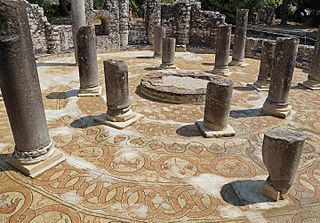
WThe baptistery at Butrint, an archeological site in Vlorë County, Albania and part of the Butrint National Park, is a late antique structure known for its well-preserved mosaic pavement. The centrally planned, circular baptistery is also notable as an ancient Roman monument adapted to the needs of Christianity.
 W
WBistricë is a river in southwestern Albania. It ends in the Ionian Sea.
 W
WButrint was an ancient Greek and later Roman city and bishopric in Epirus. Perhaps inhabited since prehistoric times, Buthrotum was a city of the Epirote tribe of the Chaonians, later a Roman colony and a bishopric. It entered into decline in Late Antiquity, before being abandoned during the Middle Ages after a major earthquake flooded most of the city. In modern times it is an archeological site in Vlorë County, Albania, some 14 kilometres south of Sarandë and close to the Greek border. It is located on a hill overlooking the Vivari Channel and is part of the Butrint National Park. Today Bouthrotum is a Latin Catholic titular see and also features the Ali Pasha Castle.
 W
WThe Butrint National Park is a national park in southern Albania, located 18 kilometres (11 mi) south of Sarandë in Vlorë County. The park encompasses 9,424 hectares (94.24 km2) of hilly terrain with freshwater lakes, wetlands, salt marshes, open plains, reed beds and islands. The park's significance for conservation is reflected in the large number of species with over 1,200 different animals and plants. Its mandate includes the protection of the lake and lagoon of Butrint, the natural channel of Vivari, the islands of Ksamil and as well the archaeological site, that provides valuable remains of ancient civilisations.
 W
WThe Cape of Gjuhëz is a rocky cape northwest of Karaburun Peninsula as well as the westernmost point of continental Albania. It projects 1.1 kilometres (0.68 mi) into the sea in the form of the tongue, thus the origin of its name. The altitudes of the cape slope gradually towards the water, whereas the southern shores form 30 to 40 metres high steep cliffs that fall directly to the Ionian sea. The cape lacks vegetation, while limestone rocks, highly eroded by Karst are spread over whole the area.
 W
WThe Cave of Haxhi Ali is a karst cave formed in limestone cliffs in southwestern Albania, located in the Karaburun Peninsula near the Cape of Gjuhëz in Vlorë County. The cave was named after Haxhi Aliu, a prominent Albanian warrior and sailor from Ulcinj who fled with his son in this cave. Several archaeological objects has been found, that prove that this cave was used by traders and passers during the ancient times. The cave has a length of 30 m (98 ft) with a width which can vary between of 10–12 m (33–39 ft) and a height of 18 m (59 ft).
 W
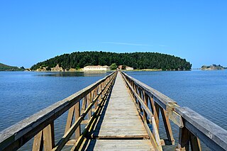
WThe Vivari Channel links Lake Butrint in Albania with the Straits of Corfu, and forms a border of the peninsula of Butrint.
 W
WThe Maja e Çikës, at 2,044 metres (6,706 ft) above sea level, is the highest peak of the Ceraunian Mountains. The Ceraunians extends approximately 100 kilometres (62 mi) along the Albanian Riviera in a northwesterly direction from Sarandë to the Karaburun Peninsula. With a prominence of 1,563 metres (5,128 ft), Maja e Çikës is the 85th most prominent mountain peak in Europe.
 W
WDelvinë District was one of the thirty-six districts of Albania. It had a population of 10,859 in 2001, and an area of 367 km². Its population included a substantial Greek community. The district is in the south of the country, and its capital was Delvinë. Its territory is now part of Vlorë County: the municipalities of Delvinë and Finiq (partly).
 W
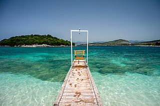
WThe Islets of Ksamil, consist of four rocky islets located in the direct proximity to the Ionian Sea in Southern Albania. The village of Ksamil, after whom the islets are named, is located to the east of the islets. Furthermore, the islands are situated within the boundaries of the Butrint National Park.
WThe Karaburun-Sazan Marine Park is a marine park in the Vlorë County of southwestern Albania. The marine park encompasses over 125.70 km2 (48.53 sq mi) and comprises the boundaries of both the Peninsula of Karaburun and the Island of Sazan. It is home to a vast array of landforms, including mountains, caves, islands, depressions, bays, cliffs, canyons and rocky coasts, all contributing to an exceptionally considerable biological diversity. The marine park has been identified as an Important Bird and Plant Area, because it supports immense bird and plant species. Containing ecosystems and habitats that are specific to the Mediterranean Basin, the convention of Barcelona has classified the marine park as a Specially Protected Areas of Mediterranean Importance.
 W
WThe Lagoon of Narta is a lagoon of the Adriatic Sea on the Mediterranean Sea in the central coast of Albania. The lagoon extends north of the Bay of Vlorë on the eastern shore of the Strait of Otranto and is separated from the sea by a narrow littoral strip, consisting of an alluvial dune. It has a surface area of 41.8 km2 (16.1 sq mi) with a maximal depth of 1.5 m (4.9 ft).
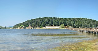
WLake Butrint is a salt lagoon south of Saranda, Albania, located in direct proximity of the Ionian Sea. It is surrounded by dense forested hills, rocky coast and complemented by saltwater and freshwater marshlands. The lake has a length of 7.1 km (4.4 mi) and a width of 3.3 km (2.1 mi), with a surface area of 16 km2 (6.18 sq mi). The maximum depth of the lake is 24.4 m (80 ft). At the south, the Vivari Channel connects the lagoon to the sea.
WThe Llogara National Park is a national park centered on the Ceraunian Mountains along the Albanian Riviera in Southwestern Albania, spanning an surface area of 1,010 ha (10.1 km2). The park's terrain includes large alpine meadows, vertical rock faces, precipices and dense forests. The most area of land is covered by forests and was established in 1966 to protect several ecosystems and biodiversity of national importance. The International Union for Conservation of Nature (IUCN) has listed the park as Category II. The region has been recognised as an important Bird and Plant Area, because it support significant numbers of various bird and plant species.
 W
WMaj 'e Shën Mërtirit is a Peninsula in Albania. It is located in the prefecture of Vlorë County, in the southern part of the country, 140 km south of the country capital, Tirana.
 W
WThe Pavllë is a river in northwestern Greece and southern Albania. Its source is in the Mourgana mountains in Greece, near the village Ampelonas, Thesprotia. It flows west into Albania, along the villages Vagalat and Shkallë. It flows into the Ionian Sea a few kilometres southwest of the archaeological site Butrint. There is a bridge across the river near the village Ampelonas, built in 1798.
 W
WThe Porto Palermo is a bay in southwestern Albania.
 W
WSarandë District was one of the thirty-six districts of Albania. It had a population of 35,235 in 2001, and an area of 730 km². The centre of the district was the city of Sarandë. Other places included Konispol, Ksamil, Çukë, Vrinë and Butrint. Its territory is now part of Vlorë County: the municipalities of Sarandë, Konispol, Finiq (partly) and Himara (partly).
 W
WSazan is an island inside the Mediterranean Sea in southern Albania. It is the largest island in Albania and strategically located between the Strait of Otranto and the entrance to the Bay of Vlorë, forming the border between the Adriatic and Ionian Sea. The island has a surface area of 5.7 km2 (2.2 sq mi) with a length of 4.8 km (3.0 mi), width of 2 km (1.2 mi) and a coastline of about 15 km (9.3 mi).
 W
WThe Shushicë or Vlora river is a river in southern Albania, tributary of the Vjosë. Its source is in the Vlorë County, near the village Kuç, municipality Himarë. It flows generally northwest through Brataj, Kotë and Shushicë and flows into the Vjosë near Armen, northeast of Vlorë.
 W
WTongo Island is an island in the Ionian Sea in southern Albania. It is a rocky island, and its waters are rich in aquatic life. The island is situated about 300 metres off the Greek coast. It has an area of 2.5 hectares.
WThe Vjosa-Narta Protected Landscape is a protected landscape area in southwestern Albania. It covers a total area of 194.12 square kilometres (74.95 sq mi), encompassing the lagoon of Narta along with the estuary of the Vjosë and its surrounding areas dotted with freshwater wetlands, marshlands, reed beds, woodlands, islands and sandy beaches. The International Union for Conservation of Nature (IUCN) has listed the park as Category VI. It is also listed as an important Bird and Plant Area, because it supports significant bird and plant species.
 W
WVlorë District was one of the thirty-six districts of Albania. It had a population of 147,267 in 2001, and an area of 1,609 km². It is in the south-west of the country, and its capital was Vlorë. Its territory is now part of Vlorë County: the municipalities of Vlorë, Selenicë and Himara (partly). Its population included a Greek minority.
WVurg is a plain and region in the southern part of Vlorë County, southwestern Albania.
 W
WZvërnec Island is an island within the Narta Lagoon in southern Albania.