 W
WAbu Jarash is a neighborhood and district of the al-Salihiyah municipality of Damascus, Syria. It had a population of 12,798 in the 2004 census. In the 1936 French Mandate census, Abu Jarash had a population of 9,600, all Muslims. The neighborhood was built around the domed mausoleum of Abu Jarash, also known as Abdallah ibn Sala al-Raqqi, a high-ranking Ayyubid royal court official.
 W
WAbu Rummaneh is an upscale neighborhood and district of the Muhajirin municipality in western Damascus, Syria. It had a population of 6,421 in the 2004 census. The quarter is centered on the palm-tree-lined Abu Rummaneh Boulevard, known officially as al-Jalaa Boulevard, named for the evacuation of French mandate troops from Syria. The neighborhood serves as Damascus' diplomatic quarter, also housing the Arab Cultural Center and the French Institute for Arab Studies (IFEAD). The smaller streets on either side of the boulevard are lined by expensive, old-money apartment buildings, owned by wealthy Damascenes.
 W
WAl-Amara, also known as al-Amarah Juwaniyyah, is a prominent neighborhood in the old city of Damascus located a few meters away from The Grand Mosque of Damascus.
WAl-Asali is a neighborhood and district of the Qadam municipality in Damascus, Syria. It had a population of 21,731 in the 2004 census. The neighborhood was built around the small al-Asali maqam (shrine), named after Shaykh Ahmad al-Asali al-Khalwati, a local Muslim holy man. The al-Asali shrine was a station in the annual Hajj pilgrim caravan, which came to an end in the early 20th century. During the caravan procession, tents were set up around the shrine to host dignitaries and pilgrims before the caravan departed the city for Mecca.
WAl-Hijaz is a neighborhood and district of the Qanawat municipality of Damascus, Syria. It had a population of 5,572 in the 2004 census. The neighborhood was founded during the early 20th century, during the last years of Ottoman rule in Syria. It was built around the Hijaz Railway station in the city, which was founded in 1913. Between 1914 and 1916, the Ottoman governor of Damascus, Jamal Pasha, commissioned the construction of Shari'a an-Naser in the neighborhood, which ran from the railway station to the Souq al-Hamidiyya bazaar, parallel to Marjeh Square and the Barada River. Several mosques and residences were demolished to make way for the monumental road.
WAl-Qassaa is a neighborhood and district of the Sarouja municipality in Damascus, Syria. Qassaa is situated in the northeastern part of the city and borders the Old City neighborhood of Bab Tuma. It had a population of 11,467 in the 2004 census. Al-Qassaa's inhabitants are predominantly upper class Christians.
 W
WAl-Salihiyah is a municipality and a neighborhood of Damascus, Syria. It lies to the northwest of the old walled city of Damascus and about 2.4 kilometres (1.5 mi) southeast the Citadel at the foot of Mount Qasioun. The quarter is famous for its cemetery of holy men. It houses the Syrian Parliament building. It also has the Hanabila Mosque.
WAl-Shaghour is a municipality and a neighborhood located in the old walled city of Damascus, Syria, south and east of the Old City, and east of al-Midan. Al-Shaghour is one of the oldest recorded neighborhoods in the city. The traditional neighborhood is divided into the part located within the Old City walls, known as Shaghour al-Juwani, and the much larger part located outside the walls. The latter part has become a municipality known as "al-Shaghour" and includes the districts (hayy) of Shaghour al-Barrani, Bab Sharqi, al-Zuhur, al-Wihdah, al-Bilal, al-Nidal, Ibn al-Asakir and Rawdat al-Midan.
 W
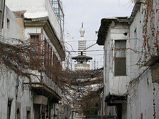
WThe Ancient City of Damascus is the historic city centre of Damascus, Syria. The old city which is one of the oldest continuously inhabited cities in the world, contains numerous archaeological sites, including some historical churches and mosques. Many cultures have left their mark, especially Hellenistic, Roman, Byzantine and Islamic. In 1979, the historical center of the city, surrounded by walls of Roman era, was declared a World Heritage Site by UNESCO. In June 2013, UNESCO included all Syrian sites on the list of World Heritage in Danger to warn of the risks to which they are exposed because of the Syrian Civil War.
 W
WBab Sharqi, also known as the Gate of the Sun, is one of the seven ancient city gates of Damascus, Syria. Its modern name comes from its location in the eastern side of the city. The gate also gives its name to the Christian quarter surrounding it. The grand facade of the gate was reconstructed in the 1960s.
WBaramkeh, named after Barmakids, is a neighborhood and district of the Qanawat municipality of Damascus, Syria. It had a population of 14,969 in the 2004 census. The neighborhood was founded during the late 19th century, during Ottoman rule. A military secondary school was established in Baramkeh in 1890s. The district contains a campus of the Damascus University.
WBarzeh is a municipality and a neighborhood to the north of Damascus, Syria. According to the Syria Central Bureau of Statistics, Barzeh had a population of 47,339 in the 2004 census.
WJobar also spelled Jawbar, Jober or Joubar, is a municipality of the Syrian capital Damascus. A once historical village on the outskirts of Damascus, it is now a suburb of the capital city. It lies 2 km northeast of the old city walls. It contains the most venerated site for Syrian Jews, an ancient 2,000-year-old synagogue and shrine in commemoration of the biblical prophet Elijah, which has been a place of Jewish pilgrimage for many centuries. Today 93% of Jobar lies in ruins due to a prolonged battle fought between the Syrian Army and various rebel groups from February 2013 to March 23 2018. It has been the site of hostilities during Syrian Civil War, including the 2017 Jobar offensive.
 W
WKafar Souseh is a municipality and neighborhood of Damascus, Syria, located in the southwestern part of the capital. It is home to the Syrian Council of Ministers and the Syrian Ministry of Foreign Affairs.
WMasjid Aqsab, also called Masjid al-Qasab, is a neighborhood and district of the Sarouja municipality of Damascus, Syria. It had a population of 14,148 in the 2004 census. The neighborhood was founded during the Mamluk era as a suburb of the walled city of Damascus, bordering the Bab al-Salam gate to the south and contiguous with the al-Faradis neighborhood to the west. It was built around the Aqsab Mosque, after which the neighborhood was named. The mosque purportedly contained the graves of seven Sahaba. In the 1936 French Mandate census, the neighborhood had a population of 6,900, all Muslims.
 W
WMezzeh is a municipality in Damascus, Syria, due west of Kafr Sousa. It lies to the southwest of central Damascus, along the Mezzeh highway.
 W
WAl-Midan is a neighbourhood and municipality in Damascus, Syria, just south of the old walled city and very near the modern city centre. In the 2004 census, it had a population of 177,456. Its streets and alleys are full of heritage and history due to the age of the neighbourhood. Throughout history, its people fought alongside their brothers from other neighbourhoods to protect Damascus. Also, there are many great Damascene scholars who were born here. Today, the neighbourhood is often considered to be one of the most conservative in Damascus.
 W
WQaboun is a municipality and neighbourhood in Damascus, Syria, located 6 kilometers (3.7 mi) north-east of the city center, to the north of Jobar district.
WQadam is a municipality and a neighborhood in the southern part of Damascus, Syria, due west of Yarmouk Camp.
WQanawat is a municipality of the Damascus, Syria, due west of the Old City. In the 2004 census, it had a population of 58,053. The municipality contains numerous government buildings such as the University of Damascus, National Museum of Damascus, Damascus Governorate Police headquarters, and the Ministries of Tourism, Information, and Interior. It also features historical places of interest such as the Hejaz Railway, Tekkiye Mosque, and Hammam al-Jadid.
 W
WAl-Qaymariyya is a quarter of the Old City of Damascus. It is located in the center of the Old City, bordering the eastern wall of the Umayyad Mosque. It had a population of 4,034 in the 2004 census.
WRukneddine or Rukn al-Din is a district of Damascus, Syria. In the 2004 census, it had a population of 92,646. It is the historic Kurdish quarter of the city.
WSarouja is a municipality of Damascus, Syria, due north of the Old Damascus. It was the first part of Damascus to be built outside the city walls in the 13th century.
WTadamon is a neighborhood and district of the al-Midan municipality of Damascus, Syria. The neighborhood has been active in the Syrian civil war.
 W
WYarmouk Camp is a 2.11-square-kilometer (520-acre) district of the city of Damascus, populated by Palestinians, with hospitals and schools. It is located 8 kilometers (5.0 mi) from the center of Damascus and within municipal boundaries. Yarmouk is an "unofficial" refugee camp; it was home to the largest Palestinian refugee community in Syria. As of June 2002, there were 112,550 registered refugees living in Yarmouk.