 W
WAgios Dimitrios is a village and a community in the municipal unit Alykes, in the central part of the island Zakynthos, Greece. As of 2011, its population was 531 for the village, and 615 for the community, which includes the village Drakas. Agios Dimitrios is 2 km south of Meso Gerakari, 5 km west of Vanato, 5 km southeast of Katastari and 9 km west of Zakynthos city. The village suffered great damage from the 1953 Ionian earthquake.
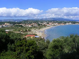
WAlikanas is a village in the municipal unit of Alykes situated on the northeastern coast about 15 km northwest of Zakynthos (city) on the island of Zakynthos, Greece. It is situated 1 km (0.6 mi) from the neighbouring village of Alykes, on the Ionian coast. Alikanas/Alykanas is a very well known tourist destination. People from all over the world are visiting Alikanas/Alykanas in the summer. It has a beautiful sandy wide beach On the beach of Alykanas you can find the lily of the sea, protected by Greek and International legislation. The famous caretta caretta might be seen sometimes in these waters, even though they prefer less populated areas.
WAlykes is a former municipality on the island of Zakynthos, Ionian Islands, Greece. Since the 2011 local government reform it is part of the municipality Zakynthos, of which it is a municipal unit. It is situated along the northeastern coast of the island, about 10 km (6.2 mi) northwest of Zakynthos (city). It has a land area of 42.881 km2 (16.6 sq mi) and a population of 5,203. The seat of the municipality was in Katastari. The next largest towns in the municipality are Skoulikádo, Agios Dimitrios (531), Pigadákia (431), Alikanas (441), and Káto Gerakári (347).
WAmpelokipoi is a village and a community in the southern part of the island of Zakynthos. It is part of the municipal unit of Zakynthos (city). In 2011 its population was 1,606 for the village and 1,930 for the community, including the village Kalpaki. It is 3 km northwest of Kalamaki, 4 km north of Laganas and 3 km southwest of Zakynthos city. The Zakynthos International Airport is 1 km southeast.
WAno Gerakari is a hilltop village and a community in the municipal unit of Alykes on the island of Zakynthos, Greece. In 2011 its population was 176 for the village and 709 for the community, which includes the villages Alonia and Kastelia. Ano Gerakari is adjacent to the northwest of Meso Gerakari, 4 km east of Katastari and 9 km northwest of Zakynthos city. It suffered great damage from the 1953 Ionian earthquake.
WArgasi is a village and a community in the southern part of the island of Zakynthos. It is part of the municipal unit of Zakynthos (city). In 2011 its population was 639 for the village and 1,266 for the community, including the village Kalliteros. It is situated on the east coast of the island, at the northwestern foot of the hill Skopos. It is 3 km southeast of Zakynthos city and 3 km northeast of Kalamaki. Argasi is a popular beach resort.
WArkadioi was a former municipality on the island of Zakynthos, Ionian Islands, Greece. Since the 2011 local government reform it is part of the municipality Zakynthos, of which it is a municipal unit. It is located on the north coast of the island. It has a land area of 26.475 km². Its population was 5,215 at the 2011 census. The seat of the municipality was in Vanato. Other large towns are Planos (742), Ágios Kírykos (733), Tragáki (622), Kalipado (709), and Sarakinádo (619).
WArtemisia is a former municipality on the island of Zakynthos, Ionian Islands, Greece. Since the 2011 local government reform it is part of the municipality Zakynthos, of which it is a municipal unit. It is on the central west coast of the island. It has a land area of 104.890 km² and a 2011 census population of 4,612 inhabitants. Its municipal seat was the town of Machairado. Other large towns are Romiri (605), Lagopodo (483), Ágios Léontas (393), Lagkadákia (357), Koiliomenos (391), and Vougiáto (306).
WBochali is a village and a community in the southern part of the island of Zakynthos. It is part of the municipal unit of the city of Zakynthos. In 2011 its population was 876 for the village, and 1,143 for the community, including the villages Akrotiri and Kydoni. It is situated on a hill near the Ionian Sea coast, 1 km northwest of Zakynthos city centre and 1.5 km east of Gaitani.
WElatia is a former municipality on the island of Zakynthos, Ionian Islands, Greece. Since the 2011 local government reform it is part of the municipality Zakynthos, of which it is a municipal unit. It is located in the northwestern part of the island. With a land area of 111.412 km², it is the largest municipal unit on Zakynthos, comprising about 27 percent of its area. Its population was 1,933 at the 2011 census. The seat of the municipality was in the town of Volimes. The next largest towns are Maries (296), Áno Volímes (262), and Orthoniés (222).
WGaitani is a village in the southern part of the island of Zakynthos. It is part of the municipal unit of Zakynthos. In 2011 its population was 1,899. It is 2 km west of Zakynthos city centre, and 2 km east of Vanato. In the Middle Ages, during the Venetian rule many, mainly small, churches were built in the Gaitani area but most of them collapsed because of the big 1953 Ionian earthquake or because of the ravages of time. There are more than 70 ruins of churches at the area.
WGyri is a settlement in the municipal unit Artemisia, on Zakynthos island, Greece. It is located northwest of Machairado and 30.5 kilometers from Zakynthos City. Its population is 34. Two roads connect the town, one which goes through the neighbouring town of Loucha, and one which comes from Agia Marina. The town consists of a main road which most of the buildings are located on. There is a church, a one-room school house, two taverns and the rest are houses. Its elevation is about 550 metres (1,800 ft).
WKalipado is a settlement on the island of Zakynthos of Greece. It is located 1 km (0.62 mi) northwest of Vanato and 5 km (3.1 mi) northwest of Zakynthos City. In 1981, the population of Kalipado was around 564 inhabitants. By 1991, the population had slightly declined to around 505 inhabitants. In 2011, the population was 736 inhabitants.
WKatastari is a village and a community in the Alykes municipal unit of the island Zakynthos, Greece. It is situated at the foot of the Vrachionas mountain, 2 km from the Ionian Sea coast. It is located 13 kilometers northwest of Zakynthos City and 10 km southeast of Volimes. In 2011, the population of Katastari was 1,378 inhabitants.
 W
WKeri is a village and a community in the southern part of the island of Zakynthos. It is situated on a hillside, close to the Ionian Sea coast. Its population in 2011 was 469 for the village and 788 for the community, which includes the villages Apelati, Limni Keriou and Marathias. The community includes the island's southernmost point, Cape Marathia. Keri is 6 km south of Lithakia and 15 km southwest of Zakynthos (city). The village suffered great damage from the 1953 Ionian earthquake.
WLaganas is a village and a former municipality on the island of Zakynthos, Ionian Islands, Greece. Since the 2011 local government reform it is part of the municipality Zakynthos, of which it is a municipal unit. The municipal unit Laganas covers the southernmost part of Zakynthos. Its municipal seat was the town of Pantokratoras. The municipal unit of Laganas has a land area of 74.104 km². Its largest towns are Mouzaki, Lithakia, Pantokratoras, Kalamaki, Laganas, and Keri. The central and eastern part of the municipal unit are flat, but there are hills up to 450 m elevation in the west. The Zakynthos International Airport lies in the eastern part of the municipal unit, near Kalamaki. The beach village Laganas, part of the community of Pantokratoras, is on the southeastern coast. A large part of Laganas is a national park, established for the protection of turtles.
WLagopodo is a settlement on Zakynthos island, Greece. Its population is 483.
WLithakia is a village in the southern part of the island of Zakynthos, Greece. In 2011 its population was 1,307. It is situated at the foot of low hills, about 2 km from the Ionian Sea coast. It is 3 km west of the beach village Laganas, 5 km southeast of Machairado and 9 km southwest of Zakynthos (city). The village suffered great damage from the 1953 Ionian earthquake.
WMachairado is a village in the central part of the island of Zakynthos, Greece. It was the seat of the municipality of Artemisia. In 2011 its population was 941. It is situated at the foot of low mountains, 1 km north of Lagopodo, 3 km northeast of Koiliomenos and 8 km southwest of Zakynthos (city). The village suffered great damage from the 1953 Ionian earthquake.
 W
WPlanos, also known as Tsilivi, is a village and a tourist resort on the island of Zakynthos, Greece. It is part of the municipal unit Arkadioi. It is situated on the northeastern coast of the island, about four kilometres northwest of the capital Zakynthos (city). The lively beach resort Tsilivi Beach is part of the community. At the north point of Tsilivi Beach, there exists an old Venetian observatory.
WRomiri is a hillside settlement on Zakynthos island, Greece. It is located between Lithakia and Machairado. It has 605 inhabitants (2011).
WVasilikos is a village and a community in the southeastern part of the municipality and the island of Zakynthos. The community consists of the villages Vasilikos, Agios Ioannis , Ano Vasilikos and Xirokastello and the uninhabited island Kalonisi. The village Vasilikos is situated at the easternmost point of Zakynthos, 11 km southeast of Zakynthos (city). The village Xirokastello is situated halfway between Argasi and Vasilikos, at the eastern foot of the hill Skopos.
WVolimes, is a village and a community in the mountainous northwestern part of the island of Zakynthos. It was the seat of the municipality of Elatia. In 2011 its population was 406 for the village, and 571 for the community, which includes the villages Agios Nikolaos, Askos, Varvara, Elies, Korithi and the uninhabited islet Agios Andreas. Volimes is located 1 km west of Ano Volimes, 3 km north of Anafonitria and 23 km northwest of Zakynthos (city). It is close to the Ionian Sea coast, and 7 km southwest of the island's northernmost point Cape Skinari. The village suffered great damage from the 1953 Ionian earthquake.
 W
WZakynthos or Zante is a Greek island in the Ionian Sea. It is the third largest of the Ionian Islands. Zakynthos is a separate regional unit of the Ionian Islands region, and its only municipality. It covers an area of 405.55 km2 (156.6 sq mi) and its coastline is roughly 123 km (76 mi) in length. The name, like all similar names ending in -nthos, is pre-Mycenaean or Pelasgian in origin. In Greek mythology the island was said to be named after Zakynthos, the son of the legendary Arcadian chief Dardanus.
WZakynthos or Zante, is a city and a former municipality on the island of Zakynthos, Ionian Islands, Greece. Since the 2011 local government reform it is part of the municipality Zakynthos, of which it is a municipal unit. It is the capital of the island of Zakynthos. Apart from the official name Zakynthos, it is also called Chora, a common denomination in Greece when the name of the island itself is the same as the name of the principal town.