 W
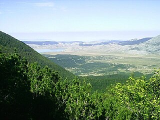
WLake Bardača is a lake and marshes complex in the municipality of Srbac, northern Republika Srpska, Bosnia and Herzegovina. It lies about 30 kilometres from Banja Luka. Area of the lake and marshes are protected as nature park, Bardača Nature Park. It is designated as a Ramsar site.
 W
WThe Bijambare area, well-known for its cave complex, is located on the far north-eastern slopes of Ilijaš, a small town near Sarajevo, capital of Bosnia and Herzegovina. It is accessible by the main road Sarajevo-Olovo, from which an asphalt road branches out leading towards a mountain home and the especially known Bijambare cave. Large parts of these caves are open to visitors.
 W
WBlidinje Nature Park is a nature park in Bosnia and Herzegovina, established on 30 April 1995. It is situated at the Blidinje plateau, in the heart of Dinaric Alps, between major mountains of the range, Čvrsnica, Čabulja and Vran, with characteristic karstic features such as Dugopolje field, Blidinje Lake, Grabovica and Drežanka valleys, and others. It represents important natural, hydrogeological reserves in Dinaric karst of Bosnia and Herzegovina, with significant cultural and historical heritage.
 W
WThe Drina is a 346 km (215 mi) long international river, which forms a large portion of the border between Bosnia and Herzegovina and Serbia. It is the longest tributary of the Sava River and the longest karst river in the Dinaric Alps which belongs to the Danube river watershed. Its name is derived from the Roman name of the river which in turn is derived from Greek.
 W
WGlavatičevo is a small village in Bosnia and Herzegovina. The village lies 30 km southeast of Konjic, within the wide Župa Valley straddling the Neretva river, in Konjic Municipality, Bosnia and Herzegovina.
 W
WHutovo Blato is a nature reserve and bird reserve located in Bosnia and Herzegovina. It is primarily composed of marshlands that were created by the underground aquifer system of the Krupa River. It is fed from the limestone massif of Ostrvo that divides the Deransko Lake and Svitavsko Lake. The reserve is on the list of BirdLife International's Important Bird Areas. It is the largest reserve of its kind in the region, in terms of both size and diversity. It is home to over 240 types of migratory birds and dozens that make their permanent home in the sub-Mediterranean wetlands surrounding Deransko Lake. In the migration season, tens of thousands of birds fill the lake and its surroundings.
 W
WIlidža is a town and a municipality located in Sarajevo Canton of the Federation of Bosnia and Herzegovina, an entity of Bosnia and Herzegovina. It has a total population of 66,730 with 63,528 in Ilidža itself, and is a chief suburb of Sarajevo and de facto its neighborhood. It is best known for the Vrelo Bosne spring, as well as the natural environment of its surroundings and historical tradition dating back to Neolithic times. Sarajevo International Airport is located nearby.
 W
WKrka river is a 6 kilometres (3.7 mi) long tributary of the Una river. It is a border river, constituting natural border between Bosnia and Herzegovina and Croatia for about 5 kilometres (3.1 mi) of its 6 kilometers long course. It is also important natural feature of the Una National Park.
 W
WKozara National Park is a national park in Bosnia and Herzegovina that was proclaimed a protected national forest in 1967 by Josip Broz Tito. It is situated between the rivers Una, Sava, Sana and Vrbas, in the Republika Srpska entity of Bosnia and Herzegovina. These 33.75 square kilometers of dense forest and hilly meadows have earned the nickname 'Green Beauty of Krajina'.
 W
WKravica waterfalls, often erroneously called Kravice, is a large tufa cascade on the Trebižat River, in the karstic heartland of Herzegovina in Bosnia and Herzegovina. It is 10 kilometres (6 mi) south of Ljubuški and 40 kilometres (25 mi) south of Mostar. Its height is about 25 metres (80 ft) and the radius of the lake in the base of the waterfall is 120 metres (390 ft). Kravica is a popular swimming and picnic area and, during the summer, it is frequently visited by tourists from Mostar, Medjugorje and Dubrovnik.
WTotal size of protected area of Bosnia and Herzegovina amounts of 57.83694 hectares, which is 1,13% of its entire territory. This is a list of areas protected by corresponding levels of the government of Bosnia and Herzegovina, namely at the entity's levels, and with various categorizations.
 W
WThe Neretva, also known as the Narenta, is one of the largest rivers of the eastern part of the Adriatic basin. Four HE power-plants with large dams provide flood protection, power and water storage. It is recognized for its natural environment and diversity of its landscape.
 W
WPerućica is one of the last remaining primeval forests in Europe. It is located in Bosnia and Herzegovina, near the border with Montenegro, and is part of the Sutjeska National Park. The forest can only be explored in the company of rangers.
 W
WPliva is a relatively small river in central parts of Bosnia and Herzegovina, however one of the most significant in terms of natural, cultural and historical heritage and value as a natural rarity. For hundreds of years this region was the ultimate stronghold of the Bosnian Kingdom, with the town of Jajce as permanent seat of the last kings of the Bosnian Kingdom.
 W
WRakitnica is the main tributary of the first section of the Neretva river, also called Upper Neretva (Bosnian: Gornja Neretva). It meets Neretva from the right, flowing from north to south, between Bjelašnica and Visočica mountains.
 W
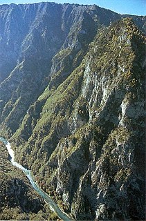
WSkakavac waterfall is formed on the Perućica, a mountain creek, in Perućica primeval forest, which is regulated as a Strict Nature Reserve as part of Sutjeska National Park in Republika Srpska, Bosnia and Herzegovina. It is one of the highest waterfalls in the country, at about 75 metres (246 ft) in height.
 W
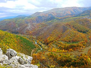
WČude Canyon is a short but deep canyon created by the Stupčanica river in central-northerneastern part of Bosnia and Herzegovina, in Olovo municipality. The Stupčanica cuts through steep slopes of Gradac, on the right bank, and Krševi, on the left, thus creating over a half of kilometer deep canyon, only 3.8 kilometers long, and just few hundreds meters wide at the rim levels, while at the river level canyon is often only 2-3 meters wide. The "Čude Canyon" is protected natural monument of Bosnia and Herzegovina.
 W
WThe Sutjeska National Park is a national park located in Bosnia and Herzegovina. Established in 1962, it is Bosnia and Herzegovina's oldest national park. It includes the highest peak of Maglić at over 2,386 metres (7,828 ft), on the border with Montenegro. The Montenegrin part of Maglić massif in the park has also formed the Trnovačko Jezero. The Strict Nature Reserve "Perućica", one of the last two remaining primeval forests in Europe, is part of the park. The park is also famous as being the location of the Battle of the Sutjeska in 1943 during World War II. It is an affiliated member of EUROPARC Federation.
 W
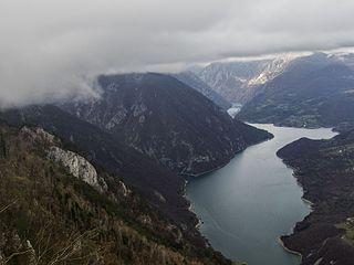
WTara River Canyon, also known as Tara River Gorge, is a part of Durmitor National Park.
 W
WThe Una is a border river between Bosnia and Herzegovina and Croatia and a right tributary of the Sava river. It is part of the Black Sea drainage basin, and its watershed has a size of 10.200 km², of which 8.080 km² belongs to Bosnia and Herzegovina, and 2.120 km² to Croatia. The total length of the river is 212 km. The source of the river is located in the town of Donja Suvaja in Croatia, and its mouth is located near the town of Jasenovac, on the border with Bosnia. The largest right tributaries are the Krka, Unac, Krušnica and Sana rivers, and the largest left tributary is the Klokot river. Its longest headwater is the Unac river. The largest and most important city located on the river is Bihać. Other, smaller cities and towns are Bosanska Krupa, Novi Grad and Kostajnica. The river is characterized by a multitude of waterfalls, rapids, karst springs and relatively untouched nature. A large part of the upper river is part of the Una National Park.
 W
WUnac River is a sinking river in Bosnia and Herzegovina. It rises beneath Šator mountain, flows through the municipality of Drvar and finally meets Una River in Martin Brod. Also runs through two deep and rugged karstic canyons and it is dammed to form small Prekajsko Lake and larger Župica Lake, before it reach town of Drvar.
 W
WGeographically and hydrologically the Neretva is divided in three sections. The upper course of the Neretva river is called the Upper Neretva, and includes vast area around the Neretva, numerous streams and well-springs, three major glacial lakes near the very river and even more scatered across the mountains of Treskavica and Zelengora in wider area of the Upper Neretva, mountains, peaks and forests, flora and fauna of the area.
 W
WVjetrenica Cave is the largest cave in Bosnia and Herzegovina, and the most biodiverse cave in the world. It is part of the Dinaric Alps mountain range, which is known for its karstic and speleological features. The cave is located in the Popovo field in Ravno, East Herzegovina in the Federation of Bosnia and Herzegovina.
 W
WVrelo Bune is the natural and architectural ensemble at the Buna river spring near Blagaj kasaba (village-town) and a part of the wider "Townscape ensemble of the town of Blagaj — Historical and Natural Heritage of Bosnia and Herzegovina", southeast of Mostar, Bosnia and Herzegovina. It is impossible to separate the natural values from the cultural and historical heritage of Blagaj, since its distinctive quality is in the coexistence of the natural and the man-made, in the integration of the physical structure into the landscape.
 W
WVranduk is historic village in the municipality of Zenica, Bosnia and Herzegovina.