 W
WAdvanced Land Observing Satellite-2 (ALOS-2), also called Daichi-2, is a 2120 kg Japanese satellite launched in 2014. Although the predecessor ALOS satellite had featured 2 optical cameras in addition to 1.2 GHz (L-band) radar, ALOS-2 had optical cameras removed to simplify construction and reduce costs. The PALSAR-2 radar is a significant upgrade of the PALSAR radar, allowing higher-resolution spotlight modes in addition to the 10 m resolution survey mode inherited from the ALOS spacecraft. Also, the SPAISE2 automatic ship identification system and the Compact Infra Red Camera (CIRC) will provide supplementary data about sea-going ships and provide early warnings of missile launches.
 W
WThe Cassini–Huygens space-research mission, commonly called Cassini, involved a collaboration between NASA, the European Space Agency (ESA), and the Italian Space Agency (ASI) to send a space probe to study the planet Saturn and its system, including its rings and natural satellites. The Flagship-class robotic spacecraft comprised both NASA's Cassini space probe and ESA's Huygens lander, which landed on Saturn's largest moon, Titan. Cassini was the fourth space probe to visit Saturn and the first to enter its orbit. The two craft took their names from the astronomers Giovanni Cassini and Christiaan Huygens.
 W
WChandrayaan-1 was the first Indian lunar probe under Chandrayaan program. It was launched by the Indian Space Research Organisation in October 2008, and operated until August 2009. The mission included a lunar orbiter and an impactor. India launched the spacecraft using a PSLV-XL rocket on 22 October 2008 at 00:52 UTC from Satish Dhawan Space Centre, at Sriharikota, Andhra Pradesh. The mission was a major boost to India's space program, as India researched and developed its own technology in order to explore the Moon. The vehicle was inserted into lunar orbit on 8 November 2008.
 W
WChandrayaan-2 is the second lunar exploration mission developed by the Indian Space Research Organisation (ISRO), after Chandrayaan-1. As of September 2019, it consists of a lunar orbiter, and also included the Vikram lander, and the Pragyan lunar rover, all of which were developed in India. The main scientific objective is to map and study the variations in lunar surface composition, as well as the location and abundance of lunar water.
 W
WCryoSat-2 is a European Space Agency environmental research satellite which was launched in April 2010. It provides scientists with data about the polar ice caps and tracks changes in the thickness of the ice with a resolution of about 1.3 centimetres.
 W
WEnvisat is a large inactive Earth-observing satellite which is still in orbit. Operated by the European Space Agency (ESA), it was the world's largest civilian Earth observation satellite.
 W
WEuropean Remote Sensing satellite (ERS) was the European Space Agency's first Earth-observing satellite programme using a polar orbit. It consisted of 2 satellites, ERS-1 and ERS-2.
 W
WFuture Imagery Architecture (FIA) was a program awarded to Boeing to design a new generation of optical and radar imaging US reconnaissance satellites for the National Reconnaissance Office (NRO). In 2005 NRO director Donald Kerr recommended the project's termination, and the optical component of the program was finally cancelled in September 2005 by Director of National Intelligence John Negroponte. FIA has been called by The New York Times "perhaps the most spectacular and expensive failure in the 50-year history of American spy satellite projects." Despite the optical component's cancellation, the radar component, known as Topaz, has continued, with four satellites in orbit as of February 2016.
 W
WGöktürk-3 is a synthetic aperture radar (SAR) Earth observation satellite that will be designed and developed under prime contractorship of Turkish Aerospace Industries (TAI) with support of Military Electronic Industries (ASELSAN) and TÜBİTAK Space Technologies Research Institute for the Turkish Ministry of National Defence.
 W
WThe Lunar Reconnaissance Orbiter (LRO) is a NASA robotic spacecraft currently orbiting the Moon in an eccentric polar mapping orbit. Data collected by LRO have been described as essential for planning NASA's future human and robotic missions to the Moon. Its detailed mapping program is identifying safe landing sites, locating potential resources on the Moon, characterizing the radiation environment, and demonstrating new technologies.
 W
WThe Magellan spacecraft, also referred to as the Venus Radar Mapper, was a 1,035-kilogram (2,282 lb) robotic space probe launched by NASA of the United States, on May 4, 1989, to map the surface of Venus by using synthetic-aperture radar and to measure the planetary gravitational field.
 W
WThe Miniature Radio-Frequency instrument (Mini-RF) is a synthetic aperture radar (SAR) instrument on the Lunar Reconnaissance Orbiter (LRO), which is currently in orbit around the Moon. It has a resolution of 30 m/pixel and two wavelength bands, a primary band at 12.6 cm and a secondary band at 4.2 cm. The original principal investigator of Mini-RF, Stewart Nozette, was arrested for espionage. Nozette was replaced by Ben Bussey, then of APL, the Applied Physics Laboratory where Mini-RF was assembled from components developed by a consortium of industry team members. Bussey accepted a position at NASA Headquarters and was replaced by the current principal investigator, Wes Patterson, also of APL. Previous SAR instruments, such as the radar on the Magellan mission to Venus, were large, massive, power-hungry, and expensive. Intended as a demonstration of cheap, lightweight SAR technology, the Mini-RF instrument was designed in response to these concerns. Because it was a technology demonstration, Mini-RF is sometimes not included in lists of LRO's instruments.
 W
WRADARSAT-1 was Canada's first commercial Earth observation satellite. It utilized synthetic aperture radar (SAR) to obtain images of the Earth's surface to manage natural resources and monitor global climate change. As of March 2013, the satellite was declared non-operational and is no longer collecting data.
 W
WRISAT is a series of Indian radar imaging reconnaissance satellites built by ISRO. They provide all-weather surveillance using synthetic aperture radars (SAR).
WRadar Imaging Satellite 1, or RISAT-1, was an Indian remote sensing satellite built and operated by the Indian Space Research Organisation (ISRO). The second RISAT satellite to be launched, it uses C-band 5.35 GHz Synthetic-Aperture Radar (SAR) for Earth observation.
 W
WRISAT-2BR1 is a synthetic-aperture radar (SAR) imaging satellite for reconnaissance built by Indian Space Research Organisation (ISRO). It is part of India's RISAT series of SAR imaging spacecraft and fourth satellite in the series. RISAT-2BR1 was launched on 11 December 2019 at 09:55 UTC aboard PSLV-C48 from First Launch Pad of Satish Dhawan Space Centre. It was the 50th launch of Polar Satellite Launch Vehicle and 75th launch from Satish Dhawan Space Centre.
 W
WSAOCOM is an Earth observation satellite constellation of Argentina's space agency CONAE. Two satellites are already orbiting the Earth in a Sun-synchronous orbit. The second one was launched on 30 August 2020.
 W
WSentinel-1 is the first of the Copernicus Programme satellite constellation conducted by the European Space Agency. This mission is composed of a constellation of two satellites, Sentinel-1A and Sentinel-1B, which share the same orbital plane. They carry a C-band synthetic-aperture radar instrument which provides a collection of data in all-weather, day or night. This instrument has a spatial resolution of down to 5 m and a swath of up to 400 km. The constellation is on a sun synchronous, near-polar (98.18°) orbit. The orbit has a 12-day repeat cycle and completes 175 orbits per cycle.
 W
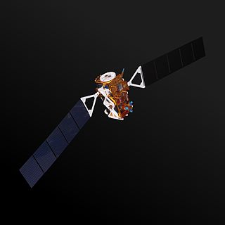
WSentinel-1A is a European radar imaging satellite launched in 2014. It is the first Sentinel-1 satellite launched as part of the European Union's Copernicus programme. The satellite carries a C-band Synthetic Aperture Radar which will provide images in all light and weather conditions. It will track many aspects of our environment, from detecting and tracking oil spills and mapping sea ice to monitoring movement in land surfaces and mapping changes in the way land is used.
 W
WThe Shuttle Radar Topography Mission (SRTM) is an international research effort that obtained digital elevation models on a near-global scale from 56°S to 60°N, to generate the most complete high-resolution digital topographic database of Earth prior to the release of the ASTER GDEM in 2009. SRTM consisted of a specially modified radar system that flew on board the Space Shuttle Endeavour during the 11-day STS-99 mission in February 2000. The radar system was based on the older Spaceborne Imaging Radar-C/X-band Synthetic Aperture Radar (SIR-C/X-SAR), previously used on the Shuttle in 1994. To acquire topographic data, the SRTM payload was outfitted with two radar antennas. One antenna was located in the Shuttle's payload bay, the other – a critical change from the SIR-C/X-SAR, allowing single-pass interferometry – on the end of a 60-meter (200-foot) mast that extended from the payload bay once the Shuttle was in space. The technique employed is known as interferometric synthetic aperture radar. Intermap Technologies was the prime contractor for processing the interferometric synthetic aperture radar data.
 W
WSoil Moisture Active Passive (SMAP) is a NASA environmental monitoring satellite launched on 31 January 2015. It was one of the first Earth observation satellites developed by NASA in response to the National Research Council's Decadal Survey.
 W
WThe Spaceborne Imaging Radar (SIR) – full name 'Spaceborne Imaging Radar-C/X-band Synthetic Aperture Radar (SIR-C/X-SAR)', is a synthetic aperture radar which flew on two separate shuttle missions. Once from the Space Shuttle Endeavour in April 1994 on (STS-59) and again in October 1994 on (STS-68). The radar was run by NASA's Space Radar Laboratory. SIR utilizes 3 radar frequencies: L band, C band (6 cm) and X band (3 cm), allowing for study of geology, hydrology, ecology and oceanography. Comparing radar images to data collected by teams of people on the ground as well as aircraft and ships using simultaneous measurements of vegetation, soil moisture, sea state, snow and weather conditions during each flight. The imaging radar was able to take images anytime regardless of clouds cover. The Radar-C system was built and operated by NASA's Jet Propulsion Laboratory (JPL). The mission was a joint work of NASA with the German and Italian space agencies. Each of the week long mission scanned about 50 million square kilometers of the Earth's surface,.
 W
WTanDEM-X is the name of TerraSAR-X's twin satellite, a German Earth observation satellite using SAR - a modern radar imaging technology. Implemented in a Public-Private-Partnership between the German Aerospace centre (DLR) and EADS Astrium, it is a second, almost identical spacecraft to TerraSAR-X. TanDEM-X is also the name of the satellite mission flying the two satellites in a closely controlled formation with typical distances between 250 and 500 m. The twin satellite constellation allowed the generation of WorldDEM global digital elevation models starting in 2014.
 W
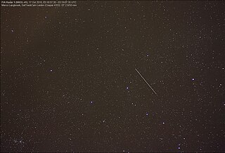
WUSA-247, also known as NRO Launch 39 or NROL-39, is an American reconnaissance satellite, operated by the National Reconnaissance Office. The USA-247 launch received a relatively high level of press coverage due to the mission's choice of logo, which depicts an octopus sitting astride the globe with the motto "Nothing Is Beyond Our Reach". The logo was extensively criticized in light of the 2013 surveillance disclosures.
 W
WVenera 16 was a spacecraft sent to Venus by the Soviet Union. This unmanned orbiter was to map the surface of Venus using high resolution imaging systems. The spacecraft was identical to Venera 15 and based on modifications to the earlier Venera space probes.The latest data from the spacecraft were received on June 13, 1985, when it responded to the signal sent from Earth for Vega 1.