 W
WFollowing an almost two-decade (1951–1970) research of the Danube Delta territory, 274 bird species were identified of which 176 were brooding and 98 non-brooding ones.
 W
WLake Biwa is the largest freshwater lake in Japan, located entirely within Shiga Prefecture, northeast of the former capital city of Kyoto. Lake Biwa is an ancient lake, over 4 million years old. It is estimated to be the 13th oldest lake in the world. Because of its proximity to the ancient capital, references to Lake Biwa appear frequently in Japanese literature, particularly in poetry and in historical accounts of battles.
 W
WThe Colorado River is one of the principal rivers in the Southwestern United States and northern Mexico. The 1,450-mile-long (2,330 km) river drains an expansive, arid watershed that encompasses parts of seven U.S. states and two Mexican states. Starting in the central Rocky Mountains of Colorado, the river flows generally southwest across the Colorado Plateau and through the Grand Canyon before reaching Lake Mead on the Arizona–Nevada border, where it turns south toward the international border. After entering Mexico, the Colorado approaches the mostly dry Colorado River Delta at the tip of the Gulf of California between Baja California and Sonora.
 W
WThe Danube Delta is the second largest river delta in Europe, after the Volga Delta, and is the best preserved on the continent. The greater part of the Danube Delta lies in Romania, with a small part in Ukraine. Its approximate surface area is 4,152 km2 (1,603 sq mi), of which 3,446 km2 (1,331 sq mi) is in Romania. With the lagoons of Razim–Sinoe, located south of the main delta, the total area of the Danube Delta is 5,165 km2 (1,994 sq mi). The Razim–Sinoe lagoon complex is geologically and ecologically related to the delta proper and the combined territory is listed as a World Heritage Site.
 W
WThe Glory River , Glory Canal or Prosperity Canal is a shallow canal in Iraq about two kilometers wide built by Saddam Hussein in 1993 to redirect water flowing from the Tigris river into the Euphrates, near their confluence at the Shatt al-Arab. It helped cause an environmental and humanitarian disaster since it diverted natural water flow from the Central Marshes and effectively converted much of the wetlands into a desert.
 W
WThe Hammar Marshes are a large wetland complex in southeastern Iraq that are part of the Mesopotamian Marshes in the Tigris–Euphrates river system. Historically, the Hammar Marshes extended up to 4,500 km2 (1,700 sq mi) during seasonal floods. They were destroyed during the 1990s by large-scale drainage, dam and dike construction projects. Since 2003, they are recovering following reflooding and destruction of dams.
 W
WThe Hawizeh Marshes are a complex of marshes that straddle the Iraq and Iran border. The marshes are fed by two branches of the Tigris River in Iraq and Karkheh River in Iran. The Hawizeh marsh is critical to the survival of the Central and Hammar marshes, which also make up the Mesopotamian Marshes, because they are a refuge for species that may recolonize or reproduce in the other marshlands. The Hawizeh Marshes are drained by the Al-Kassarah. This river plays a critical role in maintaining the marshes as a flow-through system and preventing it from becoming a closed saline basin.
 W
WInle Lake, a freshwater lake located in the Nyaungshwe Township of Taunggyi District of Shan State, part of Shan Hills in Myanmar (Burma). It is the second largest lake in Myanmar with an estimated surface area of 44.9 square miles (116 km2), and one of the highest at an elevation of 2,900 feet (880 m). During the dry season, the average water depth is 7 feet (2.1 m), with the deepest point being 12 feet (3.7 m). During the rainy season, this can increase by 5 feet (1.5 m).
 W
WLake Baikal is a rift lake located in southern Siberia, Russia, between Irkutsk Oblast to the northwest and the Buryat Republic to the southeast.
 W
WThe Lower Mississippi River is the portion of the Mississippi River downstream of Cairo, Illinois. From the confluence of the Ohio River and Upper Mississippi River at Cairo, the Lower flows just under 1000 miles to the Gulf of Mexico. It is the most heavily travelled component of the Mississippi River System.
 W
WThe Mekong, or Mekong River, is a trans-boundary river in East Asia and Southeast Asia. It is the world's twelfth longest river and the seventh longest in Asia. Its estimated length is 4,350 km (2,703 mi), and it drains an area of 795,000 km2 (307,000 sq mi), discharging 475 km3 (114 cu mi) of water annually. From the Tibetan Plateau the river runs through China, Myanmar, Laos, Thailand, Cambodia, and Vietnam. The extreme seasonal variations in flow and the presence of rapids and waterfalls in the Mekong make navigation difficult. Even so, the river is a major trade route between western China and Southeast Asia.
 W
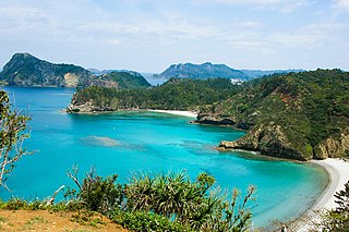
WThe Ogasawara subtropical moist forests is a terrestrial ecoregion which encompasses the Ogasawara Archipelago of Japan. The Ogasawara Archipelago lies in the Pacific Ocean south of Honshu, Japan's largest island, and north of the Marianas Islands. The ecoregion includes the Bonin Islands and Volcano Islands chains. The islands are volcanic in origin, and have never been linked to a continent. They are home to distinct plants and animals including many endemic species.
 W
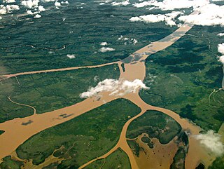
WThe Paraná Delta is the delta of the Paraná River in Argentina and it consists of several islands known as the Islas del Paraná. The Paraná flows north–south and becomes an alluvial basin between the Argentine provinces of Entre Ríos, Santa Fe and Buenos Aires then emptying into the Río de la Plata.
 W
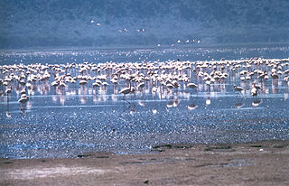
WThe Rift Valley lakes are a series of lakes in the East African Rift valley that runs through eastern Africa from Ethiopia in the north to Malawi in the south, and includes the African Great Lakes in the south. These include some of the world's oldest lakes, deepest lakes, largest lakes by area, and largest lakes by volume. Many are freshwater ecoregions of great biodiversity, while others are alkaline "soda lakes" supporting highly specialised organisms.
 W
WThe Salween, known in China as the Nu River, is a river about 2,815 kilometres (1,749 mi) long that flows from the Tibetan Plateau into the Andaman Sea in Southeast Asia.
 W
WThe San Diego River is a river in San Diego County, California. It originates in the Cuyamaca Mountains northwest of the town of Julian, then flows to the southwest until it reaches the El Capitan Reservoir, the largest reservoir in the river's watershed at 112,800 acre feet (139,100,000 m3). Below El Capitan Dam, the river runs west through Santee and San Diego. While passing through Tierrasanta it goes through Mission Trails Regional Park, one of the largest urban parks in America. The river discharges into the Pacific Ocean near the entrance to Mission Bay, forming an estuary.
 W
WThe San Luis Rey River is a river in northern San Diego County, California.
 W
WSinganallur Lake is a lake in Singanallur, Coimbatore, South India. It is spread over an area of 1.153 km2 (0.445 sq mi) and has an average depth of 4.25 m (13.9 ft). It is one of the 9 large lakes in the city.
 W
WSouthwest Australia is a biogeographic region in Western Australia. It includes the Mediterranean-climate area of southwestern Australia, which is home to a diverse and distinctive flora and fauna.
 W
WSouthwestern Sri Lanka rivers and streams is a freshwater ecoregion in Sri Lanka. The ecoregion is listed in Global 200, a list of ecoregions compiled by the World Wide Fund for Nature for conservation priorities. The extensive network of rivers and streams of Sri Lanka drains a total of 103 distinct natural river basins. Several waterfall habitats have been formed as a result of rivers and streams flowing through high and mid elevation areas. The ecoregion spreads over 15,500 km2 in the wet zone of the southwestern part of Sri Lanka. More than a quarter of the freshwater fishes that have been discovered in Southwestern Sri Lanka rivers and streams are endemic. Nine endemic genera of freshwater fishes of Western Ghats and Sri Lanka hotspot Malpulutta are found only in Sri Lanka. Studies suggest that the number of species still to be discovered is quite high. Until recently wetlands in Sri Lanka were used for drainage, construction sites and land fills.
 W
WThe Three Parallel Rivers of Yunnan Protected Areas is a UNESCO World Heritage Site in Yunnan province, China. It lies within the drainage basins of the upper reaches of the Yangtze (Jinsha), Lancang (Mekong) and Nujiang (Salween) rivers, in the Yunnan section of the Hengduan Mountains.
 W
WThe Tigris–Euphrates river system is a large river system in Western Asia which discharges into the Persian Gulf. Its principal rivers are the Tigris and Euphrates along with smaller tributaries.
 W
WTonlé Sap is a seasonally inundated freshwater lake, the Tonlé Sap Lake and an attached river, the 120 km (75 mi) long Tonlé Sap River, that connects the lake to the Mekong River. They form the central part of a complex hydrological system, in the 12,876 km2 (4,971 sq mi) Cambodian floodplain covered with a mosaic of natural and agricultural habitats that the Mekong replenishes with water and sediments annually. The central plain formation is the result of millions of years of Mekong alluvial deposition and discharge. From a geological perspective, the Tonlé Sap Lake and Tonlé Sap River are a current freeze-frame representation of the slowly but continuously shifting lower Mekong basin. Annual fluctuation of the Mekong's water volume, supplemented by the Asian monsoon regime, causes a unique flow reversal of the Tonle Sap River.
 W
WUkkadam Lake is a lake in Ukkadam, Coimbatore, South India. It is spread over an area of 1.295 km2 (0.500 sq mi) and has an average depth of 5.82 m (19.1 ft). In 2010, the lake was taken over by Coimbatore Corporation on a 90-year lease from the Public Works Department of the Government of Tamil Nadu.
 W
WThe Volga Delta is the largest river delta in Europe, and occurs where Europe's largest river system, the Volga River, drains into the Caspian Sea in Russia's Astrakhan Oblast, north-east of the republic of Kalmykia. The delta is located in the Caspian Depression—the far eastern part of the delta lies in Kazakhstan. The delta drains into the Caspian approximately 60 km downstream from the city of Astrakhan.
 W
WWood River Wetland is a marsh wetland and freshwater ecoregion in the heart of Klamath County in Southern Oregon. The wetland neighbors the north shore of Agency Lake and is the focus of a Bureau of Land Management river channel restoration project from agricultural land.