 W
WAnchawadi is a commune in the Cercle of Gao in the Gao Region of south-eastern Mali. The principal town lies at Djebock. As of 1998 the commune had a population of 7392.
 W
WAnsongo Cercle is an administrative subdivision of the Gao Region of Mali. The administrative center (chef-lieu) is the town of Ansongo. The Niger River passes through the cercle and plays an important role in transportation and the economy in the region.
WBakal is a Tuareg settlement in the Gao district of Mali.
 W
WBamba is a small town and rural commune in the Bourem Cercle of the Gao Region of Mali. The town is located on the left (north) bank of the Niger River, 190 km east of Timbuktu and 230 km northwest of the town of Gao. In the 2009 census the commune had a population of 28,524.
WBara is a rural commune and village in the Cercle of Ansongo in the Gao Region of south-eastern Mali.
WBourem is a commune and small town in the Gao Region of northeastern Mali. The town sits on the left bank of the River Niger.
 W
WBourem Cercle is an administrative subdivision of the Gao Region of north-eastern Mali. The administrative center (chef-lieu) is the town of Bourem.
WBourra is a commune in the Cercle of Ansongo in the Gao Region of south-eastern Mali. The commune extends along the left (east) bank of the River Niger. It covers an area of approximately 2,323 square kilometers and includes 14 villages. In the 2009 census the commune had a population of 19,163. The main village (chef-lieu) is Tassiga.
WForgo Sourhai is a small town and seat of the Commune of Sony Aliber in the Cercle of Gao in the Gao Region of south-eastern Mali.
WGabero is a rural commune in the Cercle of Gao in the Gao Region of south-eastern Mali. The commune covers an area of approximately 2,007 square kilometers and includes 15 villages. In the 2009 census the commune had a population of 25,688. The Niger River crosses the commune from north to south. The administrative center (chef-lieu) is Haoussa Foulane that lies on the left (east) bank of the Niger. The village is 45 km south of Gao, on the road, the N17, linking Gao and Ansongo.
 W
WGao Cercle is an administrative subdivision of the Gao Region of north-eastern Mali. The administrative center (chef-lieu) is the town of Gao.
 W
WGao International Airport, also known as Korogoussou Airport, is an airport in Gao, Mali. It is used as a base for the Dutch air force on the UN peacekeeping mission MINUSMA. The Royal Air Force has also deployed Chinook helicopters to Gao.
 W
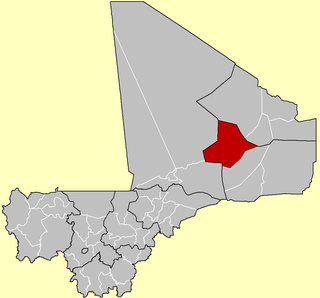
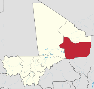
WThe Gao Region is a region in northeastern Mali. The capital city is Gao.
WGounzoureye is a rural commune in the Cercle of Gao in the Gao Region of south-eastern Mali. The commune includes the villages of Koima, Tchirissoro, Sadou, Lobou, Sidibé, Kosseye, Gorom Gorom, Kadji, Wabaria, Arhabou, Tacharane, Bagoundjé I and Bagoundjé II, which are all located on the banks of the River Niger. The administrative center (chef-lieu) is at the village of Wabaria. In the 2009 census the commune had a population of 30,772.
WHaoussa Foulane is a village and seat of the Commune of Gabero in the Cercle of Gao in the Gao Region of south-eastern Mali. The village lies on the left (east) bank of the Niger River and is 45 km south of Gao, on the road, the N17, linking Gao and Ansongo. As the name suggests, most of the people in the village are of Hausa or Fula descent.
 W
WKoïma is a village in the Commune of Gao in the Cercle of Gao in the Gao Region of south-eastern Mali. It lies on the Niger River.
WLa Dune Rose is an attraction in the city of Gao, Mali. The sand dune is named for its appearance at dawn and nightfall. It is also known as Koyma, the small town at its base.
WN'Tillit is a rural commune and village in the Cercle of Gao in the Gao Region of south-eastern Mali. In the 2009 census the commune had a population of 22,100.
WSony Aliber or Soni Ali Ber is a commune in the Cercle of Gao in the Gao Region of south-eastern Mali. The main villages are: Bagnadji, Batal, Berrah, Forgho Arma, Forgho Songhai, Kochakarey, Kokorom, Magnadoué, Seina and Zindiga. The administrative center (Chef-lieu) is the village of Forgo Sourhai which is located 25 km north of Gao. The commune includes the banks of the River Niger for a distance of around 35 km. In the 2009 census the commune had a population of 44,099.
WTaboye is a rural commune and village in the Cercle of Bourem in the Gao Region of south-eastern Mali. The commune is crossed by the River Niger and includes the villages of Bia, Dagha, Ha, Moudakane, Ouani, Tondibi and Taboye. In the 2009 census the commune had a population of 20,503.
WTalataye is a village and rural commune in the Cercle of Ansongo in the Gao Region of south-eastern Mali. The commune has an area of approximately 8,126 square kilometers. In the 2009 census it had a population of 13,907.
WTarkint is a village and commune in the Cercle of Bourem in the Gao Region of north-eastern Mali. The village is 70 km (43 mi) northeast of Bourem and 123 km (76 mi) from Gao. Tarkint extends for 23,000 km2 and includes part of the Tilemsi Valley. In the 2009 census Tarkint had a population of 19,082.
WTassiga is a village and seat of the Commune of Bourra in the Cercle of Ansongo in the Gao Region of south-eastern Mali. The village lies on the left (east) bank of the Niger River, 37 km southeast of the town of Ansongo.
WTemera is a small town and commune on the north bank of the Niger River in the Cercle of Bourem in the Gao Region of south-eastern Mali. In the 2009 census the commune had a population of 20,363.
WTessit is a small town and commune in the Cercle of Ansongo in the Gao Region of south-eastern Mali. As of 1998 the commune had a population of 6,717.
WWabaria is a small town and seat of the Commune of Gounzoureye in the Cercle of Gao in the Gao Region of south-eastern Mali.