 W
WChã de Igreja is a town in the northern part of the island of Santo Antão, Cape Verde. It is situated near the north coast of the island, in the valley of the river Ribeira da Garça, 19 km northwest of the island capital Porto Novo. In 2010 its population was 672. The nature reserve Cruzinha, which includes the small seaside village Cruzinha da Garça, stretches northeast of Chã de Igreja along the coast.
 W
WCoculi is a town in the northern part of the island of Santo Antão, Cape Verde. It is situated on the river Ribeira Grande, 4 km southwest of the town Ribeira Grande and 17 km north of the island capital Porto Novo. About 400 meters to its west is the confluence of Ribeira de Chã das Pedras.
 W
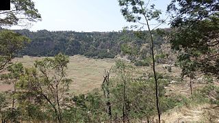
WCova is a volcanic caldera in the eastcentral part of the island of Santo Antão in Cape Verde. It is situated at the southwestern end of the municipality of Paul. Its lowest point is 1,166 meters, and the highest point of the crater rim is about 1,500 m. The diameter of the caldera is about 1.0 km. It forms a part of Cova-Paul-Ribeira da Torre Natural Park. The Cova formation dates from between 1.4 million and 700,000 years ago.
 W
WCova-Paul-Ribeira da Torre Natural Park, in the east of the island of Santo Antão, is one of ten "natural parks" in the country of Cape Verde. Its area is 20.92 km2 (8.08 sq mi), of which 8.91 km2 (3.44 sq mi) in the municipality of Ribeira Grande, 8.85 km2 (3.42 sq mi) in the municipality of Paul and 3.16 km2 (1.22 sq mi) in the municipality of Porto Novo. Since 2016, the natural park is on the tentative list of World Heritage sites.
 W
WThe Cruzinha Nature Reserve is a protected area in the northern part of the island of Santo Antão in the Cape Verde archipelago. It covers part of the north coast of the island, between the rivers Ribeira da Garça and the Ribeira do Mocho. It contains the only coastal dunes of Santo Antão. It takes its name from the village Cruzinha da Garça, part of the town Chã de Igreja.
 W
WGudo de Cavaleiro is a mountain in the middle of the island Santo Antão in Cape Verde. Its elevation is 1,810 meters. Part of the eastern plateau of Santo Antão, it lies directly south of the Moroços natural park. Nearby places are the villages Alto Mira to the west and Lagoa to the east. The mountain lies on the border of the municipalities Ribeira Grande and Porto Novo.
WPonta do Chão de Mangrade is the westernmost point of the Island of Santo Antão, and also the westernmost point of Cape Verde and all Africa. It is located 5 km northwest of Monte Trigo and 31 km west of Porto Novo, in a very remote area. The 1494 Treaty of Tordesillas divided the newly discovered lands outside Europe between Portugal and Spain along a meridian 370 leagues (2,193 km) west of this point.
WPonta do Sol is the northernmost point of both Cape Verde and the Island of Santo Antão. It is located 300 meters north of the city center of Ponta do Sol. The former Agostinho Neto Airport was located on the headland.
 W
WPaul is a concelho (municipality) of Cape Verde. Situated in the northeastern part of the island of Santo Antão, it covers 7% of the island area, and is home to 16% of its population. Its seat is the town Pombas.
 W
WPico da Cruz is a mountain in the eastern part of the island of Santo Antão. Its elevation is 1585 m. It is 5 km southwest of the town Pombas (Paul). It gives its name to the nearby village of Pico da Cruz, part of the municipality of Paul. Pico da Cruz is part of the protected area Cova-Paul-Ribeira da Torre Natural Park.
 W
WPombas is a city in the northeastern part of the island of Santo Antão, Cape Verde. It is the seat of the municipality Paul. It is situated on the coast, at the mouth of the Ribeira do Paul, 7 km (4.3 mi) southeast of Ribeira Grande and 15 km (9.3 mi) north of the island capital Porto Novo. The national roads EN1-SA02 and EN1-SA03 connect Pombas with Ribeira Grande and Porto Novo, respectively. Pombas was elevated from town to city in 2010.
 W
WPonta do Sol is the northernmost city on the island of Santo Antão and Cape Verde. It is situated on the coast, 4 km northwest of Ribeira Grande and 20 km north of the island capital Porto Novo. It is the seat of Ribeira Grande municipality.
 W
WFarol de Fontes Pereira de Melo is a lighthouse at the northeastern point of the island of Santo Antão in northwestern Cape Verde. It is situated on the headland Ponta de Tumbo, 2 km east of Janela, 6 km southeast of Pombas and 15 km northeast of Porto Novo. The lighthouse was named after Fontes Pereira de Melo, prime minister of Portugal for several times between 1871 and 1886. It is a white octagonal masonry tower, 16 meters high. Its focal height is 162 meters above sea level, and its range is 17 nautical miles. The adjacent building for the lighthouse keeper is abandoned and in poor condition.
 W
WPorto Novo is a city in the island of Santo Antão, in Cape Verde. It is the seat of the Porto Novo municipality. At the 2010 census, the town had 9,310 inhabitants, which makes it the most populous settlement of the island.
 W
WPorto Novo is a concelho (municipality) of Cape Verde. Situated in the southern part of the island of Santo Antão, it covers 72% of the island area, and is home to 41% of its population. Its population at the 2010 census was 18,028. Its capital is the town Porto Novo. Its highest point, which is also the highest point of the entire island, is Tope de Coroa, elevation 1,979 metres. The municipality of Porto Novo was created in 1962 when the parishes of São João Baptista and Santo André were separated from the older Municipality of Paul.
WPraia d'Aranhas is a beach on the northern coast of the island of Santo Antão in Cape Verde and is part of the municipality of Ribeira Grande and the village of Fontainhas. It lies east of the village of Cruzinha close to its limits and west of Ponta do Sol.
 W
WRibeira de Alto Mira is a stream in the northwestern part of the island of Santo Antão in Cape Verde. Its source is west of the mountain Gudo de Cavaleiro. It flows towards the northwest, entirely within the parish of Santo André, Porto Novo municipality. It passes the settlements of Alto Mira and Chã de Branquinho before emptying into the Atlantic Ocean.
 W
WRibeira da Garça is a river in the northern part of the island of Santo Antão in Cape Verde. Its source is on the north side of the eastern plateau of the island, northeast of Pico Moroços. It flows north through the settlements of Garça de Cima and Chã de Igreja, in the western part of the municipality of Ribeira Grande. It flows into the Atlantic Ocean near Chã de Igreja.
 W
WRibeira Grande is a stream in the northeastern part of the island of Santo Antão in Cape Verde. The stream flows from west-southwest to east-northeast, through a steep and narrow gorge. The river begins near Lombo Santa, passes through Boca de Ambas Ribeiras, Boca de Coruja and Coculi, and flows into the Atlantic Ocean at the town of Ribeira Grande. Its most important tributaries are the Ribeira de Chã das Pedras, and the Ribeira da Torre, that joins the Ribeira Grande in the town Ribeira Grande.
 W
WRibeira Grande is the largest town of the Ribeira Grande Municipality on the island of Santo Antão, Cape Verde. It has become a city in 2010. In 2010 its population was 2,564. It is situated in the northeastern part of the island, near the outflow of the river Ribeira Grande and its tributary Ribeira da Torre into the Atlantic Ocean. Neighborhoods include Tarrafal, Rua de Agua, Rua d'Horta and Penha de França.
 W
WRibeira Grande is a concelho (municipality) of Cape Verde. Situated in the northern part of the island of Santo Antão, it covers one fifth of the island area, and is home to nearly half of its population. Its seat is the city Ponta do Sol.
WRibeira do Paul is a seasonal stream that flows in the northeastern part of the island of Santo Antão in Cape Verde. The stream flows from southwest to northeast. The upper part of the valley belongs to Cova-Paul-Ribeira da Torre Natural Park.
 W
WThe Canal de São Vicente is a strait of the Atlantic Ocean separating the islands of Santo Antão and São Vicente, Cape Verde. At its narrowest point, it is 11 km (7 mi) wide. The ferry route between the ports of Porto Novo on Santo Antão and Mindelo on São Vicente crosses the canal. The channel begins in São Vicente's northwesternmost cape near Monte Cara up to the headland Ponta de João d'Évora in the northeast.
 W
WTope de Coroa is a mountain on the island of Santo Antão's, Cape Verde. At 1,979 m elevation, it is the highest point of the island. It is in the western part of the island, 25 km west of the island capital Porto Novo. The mountain is entirely of volcanic origin. The area is the source of several streams including Ribeira de Monte Trigo which flows westward to Monte Trigo.
 W
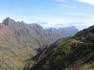
WRibeira da Torre is a torrential stream in the northeastern part of the island of Santo Antão in Cape Verde. Its source is in the mountains north of the Cova crater, near the locality Rabo Curto. It flows to the north through the settlements Xoxo, Fajã Domingas Benta and Lugar de Guene. In the city Ribeira Grande it flows into the river Ribeira Grande, just upstream of its outflow into the Atlantic Ocean. Its upper valley is part of the protected area Cova-Paul-Ribeira da Torre Natural Park. There is small-scale agriculture in the valley, producing sugar cane, coffee, yam, banana, papaya and mango.
WRibeira da Torre is a torrential stream in the northeastern part of the island of Santo Antão in Cape Verde. Its source is in the mountains north of the Cova crater, near the locality Rabo Curto. It flows to the north through the settlements Xoxo, Fajã Domingas Benta and Lugar de Guene. In the city Ribeira Grande it flows into the river Ribeira Grande, just upstream of its outflow into the Atlantic Ocean. Its upper valley is part of the protected area Cova-Paul-Ribeira da Torre Natural Park. There is small-scale agriculture in the valley, producing sugar cane, coffee, yam, banana, papaya and mango.