 W
WThe Aberystwyth Grits Group is a Silurian lithostratigraphic group in mid Wales. The name is derived from Aberystwyth in northern Ceredigion where the strata are well exposed in coastal cliffs. The Group comprises the Trefechan Formation and the underlying Mynydd Bach Formation. The rocks of the Aberystwyth Grits Group have also previously been known as the Aberystwyth Grits Formation
 W
WAvalonia was a microcontinent in the Paleozoic era. Crustal fragments of this former microcontinent underlie south-west Great Britain, southern Ireland, and the eastern coast of North America. It is the source of many of the older rocks of Western Europe, Atlantic Canada, and parts of the coastal United States. Avalonia is named for the Avalon Peninsula in Newfoundland.
 W
WThe Bala Fault is a SW-NE trending geological fault in Wales that extends offshore into Cardigan Bay. In the offshore area it is a major normal fault and forms the bounding structure to the Cardigan Bay Basin, with a fill including about 2,500 metres (8,200 ft) of Lias Group. Onshore it is responsible for the lineament which runs through Bala and south of Cadair Idris to the coast at Tywyn. At its northeastern end it links to the similarly orientated Llanelidan Fault.
 W
WThe Berw Fault is a SW-NE trending fault in North Wales. It forms part of the Menai Strait Fault System, with the Dinorwic Fault and the Aber Dinlle Fault. It has a long history of movement with early ductile fabrics preserved from a sinistral strike-slip sense shear zone active at the end of the Precambrian and into the early Cambrian. Any Caledonian deformation is unclear but the fault zone was reactivated in the Carboniferous as a NW-throwing normal fault with seismic reflection data showing the formation of a half-graben in its hanging wall. There are no indications of inversion during the Variscan Orogeny, but the fault was reactivated in a normal sense during the Permian and Triassic and again during the Cenozoic with a sinistral strike-slip sense.
 W
WCadair Ifan Goch is a crag located above the Conwy Valley in North Wales in the community of Llanddoged and Maenan, and owned by the National Trust. The views extend across the whole of the valley to the Carneddau mountains, and even as far south as the Arenig mountains. The summit of the hill, a bit further up from the crag, reaches 207 metres (679 ft) above sea level.
 W
WCefn Bryn is an ancient ridge in Britain. It is a 5-mile-long Old Red Sandstone ridge in south Wales, in the heart of the Gower Peninsula, in the City and County of Swansea. Local people colloquially refer to it as the "backbone of Gower", as it protrudes from surrounding limestone. The highest point on the ridge is the second highest point in the peninsula, offering panoramic views of the surrounding country and seas. The swathes of grassland around the ridge are known as Cefn Bryn Common.
 W
WCotham Marble or Landscape Marble is a variety of Rhaetian stromatolitic limestone from the Penarth Group, found in south Wales and southwestern England in the area around Bristol, possibly extending to the south coast in east Devon. It is named after Cotham House in Cotham, Bristol. This limestone was used for ornamental purposes, particularly during the Victorian era. On cut and polished faces the stone has the appearance of a landscape, complete with ploughed fields, trees, and hedges.
 W
WThe Fishguard Volcanic Group is an Ordovician lithostratigraphic group in west Wales. The name is derived from the town of Fishguard in Pembrokeshire. This assemblage of rocks has also been referred to as the Fishguard Volcanic Series or Fishguard Volcanic Complex. These rocks are believed to be the source of the 'bluestones' which form a part of the well-known prehistoric monument of Stonehenge in southern England.
 W
WSouth Wales is an area with many features of outstanding interest to geologists, who have for long used the area for University field trips.
 W
WVariations in the strength of gravity occur from place to place according to the density distribution of the rocks beneath the surface. Such gravity anomalies have been mapped across the British Isles and adjacent areas and they reveal aspects of these islands’ geological structure.
 W
WThe Gray Sandstone Group is a late Silurian lithostratigraphic group in west Wales. The strata are exposed in the coast around the Milford Haven area; outcrops occur either side of Marloes Bay. Besides quartzitic sandstones and mudstones, sandy rottenstones are found at outcrop. Fossils within the rottenstone beds include brachiopods and corals. The rocks of this group have also previously been known as the Gray Sandstone Series.
 W
WThe Gwna Group is a late Precambrian (Ediacaran) / Cambrian lithostratigraphic group in northwest Wales. The name is derived from the Afon Gwna, a river near Bodorgan on Anglesey where the strata are exposed. This rock sequence is also commonly referred to as the Gwna Mélange.
 W
WThe Llanbedrog Volcanic Group is an Ordovician lithostratigraphic group in northwest Wales. The name is derived from the village of Llanbedrog on the Llyn Peninsula where the strata are exposed.
 W
WThe Llewelyn Volcanic Group is an Ordovician lithostratigraphic group in Snowdonia, north-west Wales. The name is derived from Carnedd Llewelyn, the highest peak in the Carneddau range where it outcrops.
 W
WThe Marros Group is the name given to a suite of rocks of Namurian age laid down during the Carboniferous Period in South Wales. These rocks were formerly known as the Millstone Grit Series but are now distinguished from the similar but geographically separate rock sequences of the Pennines and Peak District of northern England and northeast Wales by this new name.
 W
WThe Mawddach Group is a middle to upper Cambrian lithostratigraphic group in Gwynedd, Wales. The name is derived from the river known as the Afon Mawddach.
 W
WThe Porth-y-rhaw Group is a Cambrian lithostratigraphic group in west Wales. The name is derived from Menevia, the Roman name for the St Davids area north of St Brides Bay on Pembrokeshire’s west coast where the strata are well exposed in coastal cliffs. This rock succession has previously been known variously as the Menevian Series and Menevian Beds and largely ascribed to the British regional stratigraphic unit St David’s Epoch, though these terms are now obsolete.
 W
WThe Milford Haven Group is a late Silurian to early Devonian lithostratigraphic group in west Wales. The name is derived from the estuary and town of Milford Haven in south Pembrokeshire. The Group comprises calcareous marls with occasional sandstones along with conglomerates and breccias.
 W
WThe Pennant Measures is the traditional name for a sequence of sedimentary rocks of the South Wales Coalfield. They were also referred to as the Upper Coal Measures and assigned to the Westphalian 'C' and Westphalian 'D' stages of the Carboniferous Period. The Pennant Measures were divided into the Lower Pennant Measures and the Upper Pennant Measures, differing from the underlying Middle and Lower Coal Measures in being principally of sandstone units – known collectively as the Pennant Sandstone – with mudstone being the subsidiary rock type. Numerous coal seams occur within the Pennant Measures though they are less common than in the underlying Coal Measures.
 W
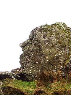
WPitt's Head is a distinctive rock located at grid reference SH576515, close to the A4085 road in Gwynedd, Wales. Its distinction lies in a resemblance to the profile of politician William Pitt the Younger.
 W
WThe Snowdon Volcanic Group is an Ordovician lithostratigraphic group in Snowdonia, north-west Wales. The name is derived from Snowdon, the highest peak in Wales where it outcrops. This assemblage of rocks has also been referred to as the Snowdon Volcanic Series.
 W
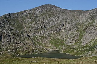
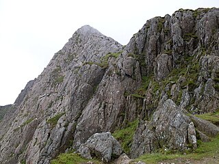
WSnowdonia is a mountainous region in northwestern Wales and a national park of 823 square miles (2,130 km2) in area. It was the first to be designated of the three national parks in Wales, in 1951. It contains the highest peaks in the United Kingdom outside Scotland.
 W
WThe Solva Group is a Cambrian lithostratigraphic group in west Wales. The name is derived from Solva on the west coast of Pembrokeshire where the strata are well exposed in coastal cliffs. This rock succession was formerly known as the Solva Series and ascribed to the British regional stratigraphic unit ‘’St David’s Epoch’’, though these terms are now obsolete.
 W
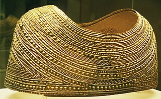
WWelsh gold is gold that occurs naturally in two distinct areas of Wales and highly prized because of its origin and scarcity. One area it is found in is North Wales in a band stretching from Barmouth, past Dolgellau and up towards Snowdonia. This was mined at several mines, the largest of which were the Gwynfynydd Gold Mine, near Ganllwyd, and the Clogau Gold Mine near Bontddu. In South Wales, it is found in a small area in the valley of the River Cothi at Dolaucothi where it is known to have been mined by the Romans.
 W
WThe Wrekin Terrane is one of five inferred fault bounded terranes that make up the basement rocks of the southern United Kingdom. The other notable geological terranes in the region are the Charnwood Terrane, Fenland Terrane, Cymru Terrane and the Monian Composite Terrane. The Wrekin Terrane is bounded to the west by the Welsh Borderland Fault System and to the east by the Malvern Lineament. The geological terrane to the west is the Cymru Terrane and to the east is Charnwood Terrane. The majority of rocks in the area are associated with the outcrops that are evident at the faulted boundaries.
 W
W