 W
WArthurson Ridge is a short coastal ridge or promontory, a northern extension from the Wilson Hills, rising between Cook Ridge and the terminus of McLeod Glacier at the head of Davies Bay, Antarctica. It was photographed from aircraft of U.S. Navy Operation Highjump, 1946–47, and first visited by an Australian National Antarctic Research Expeditions (ANARE) airborne field party in March 1961. It was named for J. Arthurson, helicopter pilot with ANARE on the MV Magga Dan in 1961.
 W
WBabushkin Island is a small island lying 10 kilometres (5.5 nmi) north of Archer Point and 9 kilometres (5 nmi) east of Matusevich Glacier Tongue, Oates Land, Antarctica. It was mapped by the Soviet Antarctic Expedition (1958) and named for Mikhail Babushkin, a Soviet polar aviator lost in the Arctic.
 W
WThe Berg Mountains are two ridges of six nunataks in Antarctica, 14 nautical miles (26 km) south of Cape Buromskiy, Krylov Peninsula. They were photographed by U.S. Navy Operation Highjump, 1946–47, the Soviet Antarctic Expedition, 1958, and the Australian National Antarctic Research Expeditions, 1959. The feature was visited by an airborne survey party from the Soviet expedition and called "Gory L'va Berga" after the Soviet geographer Lev Berg.
 W
WThe Boomerang Range,, is a narrow mountain range on the western side of the Skelton Glacier and Skelton Névé, Antarctica. The range is curved like a boomerang, and extends generally north–south for about 25 km. It was mapped and named in 1957 by geologists in the New Zealand party of the Commonwealth Trans-Antarctic Expedition (CTAE), 1956–58.
 W
WThe Bourgeois Nunataks are a group of nunataks 12 nautical miles (22 km) southwest of Governor Mountain in the Wilson Hills. They were mapped by the United States Geological Survey from surveys and from U.S. Navy air photos, 1960–63, and named by the Advisory Committee on Antarctic Names for William L. Bourgeois, Chief Aviation Machinist's Mate, U.S. Navy, a flight engineer on LC-130 Hercules aircraft during Operation Deep Freeze 1967 and 1968.
 W
WThe Brown Hills are a group of mainly snow-free hills in the Cook Mountains, lying north of the lower reaches of Darwin Glacier. They were named for their color by the Darwin Glacier Party of the Commonwealth Trans-Antarctic Expedition (1956–58).
WCoombes Ridge is a rocky coastal ridge 2 nautical miles (4 km) west of Magga Peak. The ridge, which runs roughly north-south, forms the eastern extremity of Lauritzen Bay. This area was photographed from the air by U.S. Navy Operation Highjump in 1947, and the ridge was mapped on February 20, 1959 by Australian National Antarctic Research Expeditions, led by Phillip Law. It was named by the Antarctic Names Committee of Australia for Bruce Coombes, an airport engineer working for the Australian Department of Civil Aviation, who accompanied the expedition to investigate potential airfield sites at Wilkes Station and elsewhere.
 W
WThe Daniels Range is a principal mountain range of the Usarp Mountains, about 80 km (50 mi) long and 16 km (10 mi) wide, bounded to the north by Harlin Glacier and to the south by Gressitt Glacier. The range was mapped by USGS from surveys and U.S. Navy air photos, 1960–63. Named by US-ACAN after Ambassador Paul C. Daniels (1903–86), a leading American figure in the formulation of the Antarctic Treaty in 1959.
WThe Echelmeyer Ice Stream, formerly known as Ice Stream F, is a glaciological feature of the West Antarctic Ice Sheet. It is an ice stream flowing west to the Shirase Coast to the north of the MacAyeal Ice Stream, and is one of several major ice streams draining from Marie Byrd Land into the Ross Ice Shelf. The ice streams were investigated and mapped by U.S. Antarctic Research Program personnel in a number of field seasons from 1983–84 and originally named Ice Stream A, B, C, etc., according to their position from south to north.
WHarald Bay is a bay about 4 nautical miles (7 km) wide indenting the coast between Archer Point and Williamson Head in Oates Land, Antarctica. It contains Kartografov Island. The bay was photographed from the air by U.S. Navy Operation Highjump in 1947. It was sketched and photographed by Phillip Law, leader of the Australian National Antarctic Research Expeditions on February 20, 1959, and was named by the Antarctic Names Committee of Australia for Captain Harald Moller Pederson, master of the Magga Dan during the expedition.
WKartografov Island is a small coastal island lying in the western part of the mouth of Harald Bay, Oates Land, Antarctica. It was photographed by U.S. Navy Operation Highjump (1946–47), the Soviet Antarctic Expedition (1957–58) and the Australian National Antarctic Research Expedition (1959). The island was named "Ostrov Kartografov" by the Soviet expedition.
WKrylov Peninsula is an ice-covered peninsula west of Lauritzen Bay on Oates Coast, Antarctica. It was photographed by U.S. Navy Operation Highjump (1946–47), the Soviet Antarctic Expedition (1957–58), and the Australian National Antarctic Research Expeditions (1959). It was named by the Soviet expedition after Soviet mathematician and academic naval architect Alexei Krylov.
WLauritzen Bay is a bay about 12 nautical miles (22 km) wide, occupied by bay ice and ice shell, indenting the coast of Antarctica between Cape Yevgenov and Coombes Ridge. The Matusevich Glacier Tongue joins Coombes Ridge in forming the west side of the bay. It was photographed from the air by U.S. Navy Operation Highjump in 1947, and was sketched and photographed by Phillip Law, leader of the Australian National Antarctic Research Expedition (ANARE) on the Magga Dan on February 20, 1959. It was then named by the Antarctic Names Committee of Australia for shipowner Knud Lauritzen of Copenhagen, Denmark, who supplied the Magga Dan and other vessels used by ANARE since 1954.
WLeningradskaya station is a Russian Antarctic research station, located in the northern shore of Victoria Land, at the Oates Coast. It was opened on February 25, 1971 by the members of the 15th Soviet Antarctic Expedition. It closed in 1991, but during its lifetime was host to studies of meteorology, Earth magnetism, oceanology and glaciology.
WMount McClintock is the highest mountain in the Britannia Range in Antarctica, surmounting the south end of Forbes Ridge, 10 kilometres (6.2 mi) east of Mount Olympus. It was discovered by the Discovery expedition (1901–04) and named for Admiral Sir Leopold McClintock, Royal Navy, a member of the Ship Committee for the expedition.
 W
WMount Archer is a rock peak immediately south of Archer Point on the west side of Harald Bay in Antarctica. The peak was mapped from aerial photos taken in February 1959 by the ANARE led by Phillip Law. It is named after Archer Point.
 W
WOates Coast is that portion of the coast of Antarctica between Cape Hudson and Cape Williams. It forms the coast of Oates Land, part of the Australian claim to the Antarctic. The eastern portion of this coast was discovered in February 1911 by Lieutenant Harry Pennell, Royal Navy, commander of the expedition ship Terra Nova during the British Antarctic Expedition, 1910–13. He named the coast after Captain Lawrence E.G. Oates who, with Captain Robert F. Scott and three British Antarctic Expedition companions, perished on the return journey from the South Pole in 1912. Captain Oates' death was described by Robert Falcon Scott as "the act of a brave man and English gentleman". The western portion of the coast, the vicinity of the Mawson Peninsula, was first delineated from air photos taken by U.S. Navy Operation Highjump, 1946–47.
 W
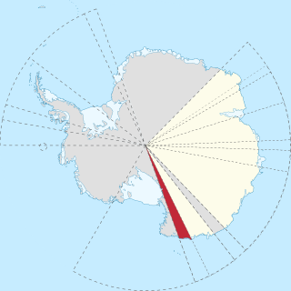
WOates Land is a region of Antarctica. It is variously defined as a portion of the East Antarctica near the coast stretching along and inland from the Oates Coast and as an officially-delineated wedge-shaped segment of the Australian Antarctic Territory. The segment of the Australian claim extends between 153°45' E and 160° E, forming a wedge between Latitude 60° S and the South Pole. It is bounded in the east by the Ross Dependency and overlaps George V Land to the west.
WMount Perez is a mountain at the south side of the upper reaches of Suvorov Glacier, 6 nautical miles (11 km) southwest of Hornblende Bluffs, in the Wilson Hills. Named by Advisory Committee on Antarctic Names (US-ACAN) for Manuel J. Perez, Photographer's Mate, U.S. Navy member of the United States Geological Survey (USGS) Topo West survey party that established geodetic control for features between Cape Adare and the Wilson Hills during 1962–63.
 W
WPortal Mountain is a large mountain in Antarctica. The mountain has a broad ice-capped summit, and stands south of the Lashly Mountains, on the south side of the main stream of the Skelton Glacier where it leaves the polar plateau.
WPritchard Peak is a peak in Antarctica rising to over 1800m, 3 nautical miles (6 km) southeast of Saburro Peak in the Doll Mountains, Britannia Range. Named after Colonel Marion Graham Pritchard, Jr., who served as Vice Commander and then Commander of the 109th Airlift Wing during the transition of LC-130 operations from the U.S. Navy to the Air National Guard
WMount Rhone is the highest peak in the Bucknell Ridge in the northeast part of the Britannia Range. Named by the Advisory Committee on Antarctic Names (US-ACAN) after Christopher M. Rhone, a communications officer with the U.S. Naval Support Force, Antarctica, 1992–94; Director of Information Systems with the ASA, 1994–2000.
WSaburro Peak is a peak in Antarctica to the south of Doll Peak in the south part of Ravens Mountains, Britannia Range. Named after Colonel Richard M.Saburro, Commander, Operation DEEP FREEZE who was assigned to this position from the 109 AG of the New York Air National Guard. Saburro was the first US Air Force Commander of Operation DEEP FREEZE following 45 years of command by the US Navy. The Operation provides military logistics support to the National Science Foundation's US Antarctic Program.
WMount Stent is 2,010 m (6,590 ft) mountain at the southern extreme of the Wallabies Nunataks, west of the Churchill Mountains.
 W
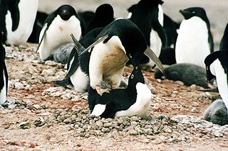
WSturge Island is one of the three main islands in the uninhabited Balleny Islands group located in the Southern Ocean. It lies 25 km (16 mi) southeast of Buckle Island and 95 km (59 mi) north-east of Belousov Point on the Antarctic mainland. The island, in Oates Land, also forms part of the Ross Dependency, claimed by New Zealand.
WTalos Dome is a large ice dome rising to 2,300 m to the southwest of the Usarp Mountains in Antarctica. The dome overlies the east margin of the Wilkes Subglacial Basin. The feature was delineated by the Scott Polar Research Institute (SPRI)-National Science Foundation (NSF)-Technical University of Denmark (TUD) airborne radio echo sounding program, 1967–79, and was named after Talos of Greek mythology, who assisted Minos in the defense of Crete.