 W
WThe 2010 Senkaku boat collision incident occurred on the morning of September 7, 2010, when a Chinese trawler, Minjinyu 5179, operating in disputed waters near the Senkaku Islands collided with Japanese Coast Guard's patrol boats. There were several Japanese Coast Guard boats involved, including Yonakuni and Mizuki, which collided with Minjinyu 5179, plus Hateruma and other JCG boats.
 W
WThe East China Sea Air Defense Identification Zone is an Air Defense Identification Zone covering most of the East China Sea where the People's Republic of China announced that it was introducing new air traffic restrictions in November 2013. The area consists of the airspace from about, and including, the Japanese controlled Senkaku Islands north to South Korean-claimed Socotra Rock. About half of the area overlaps with a Japanese ADIZ, while also overlapping to a small extent with the South Korean and Taiwanese ADIZ. When introduced the Chinese initiative drew criticism as the ADIZ overlapped with the ADIZ of other countries, imposed requirements on both civilian and military aircraft regardless of destination, and included contested maritime areas
 W
WThe Constitution of the Republic of China is the fifth and current constitution of the Republic of China, ratified by the Kuomintang during the Constituent National Assembly session on December 25, 1946, in Nanjing, and adopted on December 25, 1947. The constitution, along with its Additional Articles, remains effective in ROC-controlled territories.
 W
WDangerous Ground is a large area in the southeast part of the South China Sea characterized by many low islands and cays, sunken reefs, and atolls awash, with reefs often rising abruptly from ocean depths greater than 1000m.
 W
WThere are disputes between China, Japan, and South Korea over the extent of their respective exclusive economic zones (EEZs) in the East China Sea.
 W
WKowloon Walled City was an ungoverned, densely populated de jure Chinese enclave within the boundaries of Kowloon City, Hong Kong. Originally a Chinese military fort, the walled city became an enclave after the New Territories were leased to the UK by China in 1898. Its population increased dramatically following the Japanese occupation of Hong Kong during World War II. By 1990, the walled city contained 50,000 residents within its 2.6-hectare (6.4-acre) borders. From the 1950s to the 1970s, it was controlled by local triads and had high rates of prostitution, gambling, and drug abuse.
 W
WMacclesfield Bank is an elongated sunken atoll of underwater reefs and shoals in the South China Sea. It lies east of the Paracel Islands, southwest of Pratas Island and north of the Spratly Islands. Its length exceeds 130 km (81 mi) southwest-northeast, with a maximal width of more than 70 km (43 mi). With an ocean area of 6,448 km2 (2,490 sq mi) within the outer rim of the reef, although completely submerged without any emergent cays or islets, it is one of the largest atolls of the world. The Macclesfield Bank is part of what China calls the Zhongsha Islands, which includes a number of geographically separate submarine features, and also refers to a county-level administrative division.
 W
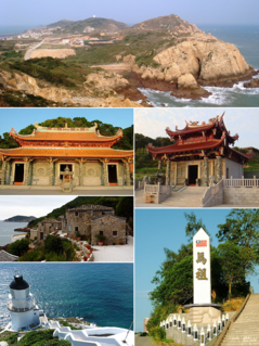
WThe Matsu Islands are an archipelago of 36 islands and islets in the East China Sea officially named Lienchiang County in the Republic of China (Taiwan). It is the smallest county in the free area of the Republic of China.
 W
WThe New Territories is one of the three main regions of Hong Kong, alongside Hong Kong Island and the Kowloon Peninsula. It makes up 86.2% of Hong Kong's territory, and contains around half of the population of Hong Kong. Historically, it is the region described in the Convention for the Extension of Hong Kong Territory. According to that treaty, the territories comprise the mainland area north of the Boundary Street of Kowloon Peninsula and south of the Sham Chun River, as well as over 200 outlying islands, including Lantau Island, Lamma Island, Cheung Chau, and Peng Chau in the territory of Hong Kong.
 W
WThe nine-dash line—at various times also referred to as the ten-dash line and the eleven-dash line—refers to the undefined and vaguely located demarcation line used by China and Taiwan, for their claims of the major part of the South China Sea. The contested area in the South China Sea includes the Paracel Islands, the Spratly Islands, and various other areas including Pratas Island and the Vereker Banks, the Macclesfield Bank and the Scarborough Shoal. The claim encompasses the area of Chinese land reclamation known as the "Great Wall of Sand".
 W
WOuter Mongolia was a territory of the Qing dynasty (1691–1911). Its area was roughly equivalent to that of the modern state of Mongolia, sometimes called "Outer Mongolia" in China today, plus the Russian republic of Tuva.
 W
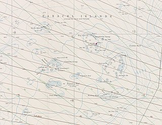
WThe Paracel Islands, also known as Xisha Islands and Hoang Sa Archipelago, are a disputed archipelago in the South China Sea.
 W
WPratas Island is an island in the northern part of the South China Sea administered as part of Cijin District, Kaohsiung, Republic of China (Taiwan). It is located about 170 nautical miles southeast of Hong Kong. It has an area of about 240 hectares, including 64 hectares of lagoon, and is the largest of the South China Sea Islands. It is the location of the Dongsha Airport.
 W
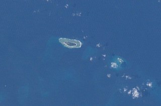
WRocky Island is one of the Paracel Islands in the South China Sea. It is under the administration of the People's Republic of China and guarded by the PLA Navy. The island is also claimed by Taiwan and Vietnam.
 W
WSabina Shoal is an atoll in the NE of Dangerous Ground in the Spratly Islands, South China Sea. It is claimed by the People's Republic of China, the Republic of China (Taiwan) and the Philippines. The Philippines puts it under the jurisdiction of barangay Pag-asa, Kalayaan, Palawan.
 W
WScarborough Shoal, also known as Bajo de Masinloc (Spanish), Panatag Shoal, Huangyan Island and Democracy Reef, are two rocks in a shoal located between the Macclesfield Bank and Luzon island in the South China Sea. The nearest land mass from it is Luzon, the largest island in the Philippines.
 W
WSecond Thomas Shoal is a shoal/atoll in the Spratly Islands of the South China Sea, 105 nautical miles west of Palawan, Philippines. Claimed by several nations, the shoal is currently militarily occupied by the Philippines and a Philippine Territory.
 W
WThe Senkaku Islands are a group of uninhabited islands in the East China Sea. They are located east of mainland China, northeast of Taiwan, west of Okinawa Island, and north of the southwestern end of the Ryukyu Islands. They are known in mainland China as the Diaoyu Islands or Diaoyu Dao and its affiliated islands, in Taiwan as the Tiaoyutai Islands / Diaoyutai Islands, and in the Western World are sometimes impartially referred to by the historical name Pinnacle Islands. In Okinawan they are called yukunkubajima. In Yaeyama dialect, they are called iigunkubajima.
 W
WThe Senkaku Islands dispute, or Diaoyu Islands dispute, concerns a territorial dispute over a group of uninhabited islands known as the Senkaku Islands in Japan, the Diaoyu Islands in the People's Republic of China (PRC), and Tiaoyutai Islands in the Republic of China. Aside from a 1945 to 1972 period of administration by the United States as part of the Ryukyu Islands, the archipelago has been controlled by Japan since 1895. According to Lee Seokwoo, the People's Republic of China (PRC) started taking up the question of sovereignty over the islands in the latter half of 1970 when evidence relating to the existence of oil reserves surfaced. Taiwan also claims the islands. The territory is close to key shipping lanes and rich fishing grounds, and there may be oil reserves in the area.
 W
WThe Shandong Problem was a dispute over Article 156 of the Treaty of Versailles in 1919, which dealt with the concession of the Shandong Peninsula. It was resolved in China's favor in 1922.
 W
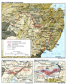
WThe Sixty-Four Villages East of the River were a group of Manchu and Han Chinese-inhabited villages located on the left (north) bank of the Amur River opposite of Heihe, and on the east bank of Zeya River opposite of Blagoveshchensk. The area totaled 3,600 square kilometers (1,400 sq mi).
 W
WThe South China Sea is a marginal sea of the Western Pacific Ocean. It is bounded in the north by the shores of South China, in the west by the Indochinese Peninsula, in the east by the islands of Taiwan and northwestern Philippines, and in the south by Borneo, eastern Sumatra and the Bangka Belitung Islands, encompassing an area of around 3,500,000 km2 (1,400,000 sq mi). It communicates with the East China Sea via the Taiwan Strait, the Philippine Sea via the Luzon Strait, the Sulu Sea via the straits around Palawan, the Strait of Singapore, and the Java Sea via the Karimata and Bangka Strait. The Gulf of Tonkin is both part of the South China Sea, and its shallow waters south of the Riau Islands is also known as the Natuna Sea.
 W
WThe Spratly Islands dispute is an ongoing territorial dispute between China, Taiwan, Malaysia, the Philippines, Vietnam, and Brunei, concerning "ownership" of the Spratly Islands, a group of islands and associated "maritime features" located in the South China Sea. The dispute is characterised by diplomatic stalemate and the employment of military pressure techniques in the advancement of national territorial claims. All except Brunei occupy some of the maritime features.
 W
WTaiping Island, also known as Itu Aba, and also known by various other names, is the largest of the naturally occurring Spratly Islands in the South China Sea. The island is elliptical in shape being 1.4 kilometres (0.87 mi) in length and 0.4 kilometres (0.25 mi) in width, with an area of 46 hectares. It is located on the northern edge of the Tizard Bank. The runway of the Taiping Island Airport is easily the most prominent feature on the island, running its entire length.
 W
WTannu Uriankhai is a historic region of the Mongol Empire and, later, the Qing dynasty. The realms of Tannu Uriankhai largely correspond to the Tuva Republic of the Russian Federation, neighboring areas in Russia, and a part of the modern state of Mongolia.
WWoody Island, also called Yongxing Island in People's Republic of China (PRC) and Phu Lam Island in Vietnam, is the largest of the Paracel Islands in the South China Sea (SCS), with an area of 2.1 square kilometres (0.81 sq mi). It has a population of more than 1,000 people, with roads, banks and a "small" air strip. The Paracel Islands are a group of islands, reefs, banks and atolls in the northwestern part of the South China Sea. Woody Island is part of the Amphitrite Group in the eastern Paracels and is approximately equidistant from Hainan and the Vietnam coast.