 W
WBirchgrove is a large village and community in the City and County of Swansea, Wales. It does not have a community council. The village is situated some 4.5 miles (7 km) north-east of Swansea city centre, between the flood plain of the River Tawe and Mynydd Drumau. Birchgrove also borders Neath Port Talbot. The community of Birchgrove, which includes the village of Birchgrove itself, Lon-las, and parts of Glais, had a population in 2008 of 5,807. and 7,392 in 2011.
 W
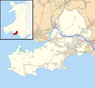
WBishopston is a large village and community situated on the Gower Peninsula, some 6 miles (9.7 km) west south west of the centre of Swansea in South Wales.
 W
WCastle is an electoral ward and community in the City and County of Swansea, Wales, UK. Castle covers most of the heart of the City of Swansea, with Swansea Castle at its centre.
 W
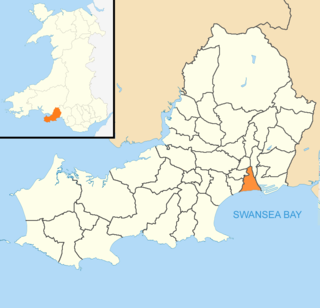
WClydach is both a village and a community in Swansea, Wales, within the Clydach ward and the Llangyfelach Parish. It is located 6 miles (9.7 km) northeast of Swansea city centre. The population in 2011 was 7,503. Welsh is the first language of 24 per cent of the population and both Welsh and English language schools are available. The village lies close to the M4 motorway which can be accessed via the bypass or old road via Ynystawe. The community includes part of the village of Glais.
 W
WCockett is a district and community in Swansea, Wales falling within Cockett ward. It is located about 1.5 miles (2.4 km) north-west of Swansea city centre.
 W
WCwmbwrla is a residential area and community of Swansea in Wales, within the Cwmbwrla ward of the city. Located on rising ground about 1 mile (1.6 km) north of the city centre, it takes its name from the valley of the Burlais Brook which flows down from here to join the River Tawe immediately northeast of Swansea railway station. The neighbouring districts are Manselton, Greenhill, Mayhill, Townhill, and Cwmdu.
 W
WGorseinon is a town within the City and County of Swansea, Wales, near the Loughor estuary. It was a small village until the late 19th century when it grew around the coal mining and tinplate industries. It is situated in the north west of Swansea City Centre, around 6 miles (10 km) north west of the city centre. Gorseinon is a local government community with an elected town council.
 W
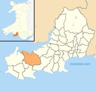
WGowerton is a large village and community, about 4 miles north west of Swansea city centre, Wales. Gowerton is often known as the gateway to the Gower Peninsula. Gowerton's original name was Ffosfelin. The village falls within the Gowerton electoral ward of the City and County of Swansea Council, which elects one councillor. The community had a population of 5,212. and the built-up area with Waunarlwydd 8,183.
 W
WGrovesend is a village in the community of Grovesend and Waungron, City and County of Swansea in Wales. The community has a population of 1,131.
 W
WLandore is a district and community in Swansea, Wales. The district falls in the Landore council ward. A mainly residential area, it is located about 2.5 miles north of Swansea city centre. The north-easterly part of Landore is known as Morfa. There have been a number of new developments in the 21st century, such as the Liberty Stadium and the Morfa Shopping Park, which opened in 2005. It had a population of 6,168 as of the 2011 UK census.
 W
WLlangennith, Llanmadoc and Cheriton is a rural community on the Gower Peninsula, Swansea, south Wales. It comprises the villages of Llangennith, Llanmadoc and Cheriton. Together they share a community council.
 W
WLlangyfelach is a village and community located in the City and County of Swansea, Wales. Llangyfelach is situated about 4 miles north of the centre of Swansea, just west of Morriston. It falls within the Llangyfelach ward. To the west is open moorland. The population was 2,510 as of the 2011 UK census.
 W
WLlanrhidian Higher is a local government community in Swansea, south Wales. The community has its own elected community council.
 W
WLlanrhidian Lower is a community in the Gower peninsula forming the west of Swansea, south Wales. The community has its own elected community council. The population was 512 as of the 2011 UK census.
WLlansamlet is a suburban district and community of Swansea, Wales, falling into the Llansamlet ward. The area is centred on the A48 road and the M4 motorway.
 W
WMawr is both an electoral ward and a community of the City and County of Swansea, in south Wales, U.K. Mawr has its own elected community council. Its name simply means "large", and it was given the name because it was the largest piece of land in the former parish of Llangyfelach.
 W
WMumbles is a community in the City and County of Swansea, Wales, covering the district of the same name. It includes the local government electoral wards of Mayals, Newton, Oystermouth and West Cross.
WMynydd-Bach or Mynydd-bach is a suburban district and community in the City and County of Swansea, Wales, It falls within the coterminous Mynydd-Bach ward. The name Mynydd-Bach refers to a small plateau, centred about 2.5 miles (4 km) north of Swansea city centre. The most important local employer is the DVLA, which moved here in 1974. The population as of the 2011 UK census was 8,872.
 W
WPenderry is the name of an electoral ward and a community in the City and County of Swansea, Wales, UK. Penderry does not have a community council.
 W
WPontarddulais is a community and town in the City and County of Swansea, Wales, situated 10 miles (16 km) northwest of Swansea city centre and falls within the Pontarddulais ward. It adjoins the village of Hendy in Carmarthenshire and the built-up population was 9,073.
 W
WPontlliw and Tircoed is a community in the north of the City and County of Swansea, Wales. It includes the villages of Pontlliw and Tircoed.
WPort Eynon is a village and community within the City and County of Swansea, Wales, located on the far south tip of the Gower Peninsula within the designated Area of Outstanding Natural Beauty. The A4118 from Swansea city centre terminates here.
 W
WRhossili is both a small village and a community on the southwestern tip of the Gower Peninsula in Wales. It is within the first Area of Outstanding Natural Beauty in the United Kingdom. The village has a community council and is part of the Gower parliamentary constituency, and the Gower electoral ward. At the 2011 census, the population was 278. The community includes the hamlet of Pitton.
 W
WSt Thomas is a suburban district and community in Swansea, Wales. It is a mainly residential area which lies east of Swansea city centre across the River Tawe and falls within the St Thomas ward. Fabian Way divides the traditional residential area from Swansea Docks, which has been developed during the 2010s to create a new area of commercial activities and apartments.
WThe suburban district of Sketty is located about 2 miles (3.2 km) to the west of the Swansea city centre on Gower Road. Sketty falls within the Sketty council ward of Swansea. It is also a community.
 W
WTownhill is the name of a hill, a residential district and a community and electoral ward in Swansea, Wales, UK. It had a population of 8,696 in 2011.
 W
WUplands is a suburb and community of Swansea, Wales. It lies about a mile (2 km) to the west of Swansea city centre, and falls within the Uplands electoral ward. It is centred on the A4118 road, which links Swansea city centre and Sketty. The main road begins as Walter Road from the east, and becomes Sketty Road towards the west. Much of the area is hilly. The population of the community and ward in 2011 was 15,665 and in terms of Welsh identity had the lowest percentage in the county.