 W
WAmager Vest is one of the ten administrative districts of Copenhagen Denmark. It located on in the north-western part of the island of Amager, the largest island in the Øresund. The district is bordered by Amager Øst to the east along Amagerbrogade, the main shopping street and thoroughfare of the part of Copenhagen. Amager Vest is the largest of the ten new official administrative districts of Copenhagen, but has at the same time the smallest population. Only the most northern part can be considered as "urban area".
 W
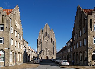
WBispebjerg, more commonly referred to as Nordvest , is one of the 10 official districts of Copenhagen, Denmark. Located on the northern border of the municipality, it covers an area of 5.39 km² and a population of 40,033. More specifically, Bispebjerg refers to a smaller neighbourhood within the district, located on the Bispebjerg Hill from which it takes its name.
 W
WChristianshavn is a neighbourhood in Copenhagen, Denmark. Part of the Indre By District, it is located on several artificial islands between the islands of Zealand and Amager and separated from the rest of the city centre by the Inner Harbour. It was founded in the early 17th century by Christian IV as part of his extension of the fortifications of Copenhagen. Originally, it was laid out as an independent privileged merchant's town with inspiration from Dutch cities but it was soon incorporated into Copenhagen proper. Dominated by canals, it is the part of Copenhagen with the most nautical atmosphere.
 W
WEnghave Brygge is a waterfront area in the Southern Docklands of Copenhagen, Denmark. It is located between Teglholmen to the south and Kalvebod Brygge to the north. Currently an abandoned industrial site, a plan for its redevelopment was adopted in July 2013. The most prominent landmark in the area is the H. C. Ørsted Power Station.
 W
WFrederiksstaden is a district in Copenhagen, Denmark. Constructed during the reign of Frederick V in the second half of the 18th century, it is considered to be one of the most important rococo complexes in Europe and was included in the 2006 Danish Culture Canon.
 W
WGammelholm is a predominantly residential neighbourhood in the city centre of Copenhagen, Denmark. It is bounded by the Nyhavn canal, Kongens Nytorv, Holmens Kanal, Niels Juels Gade and the waterfront along Havnegade. For centuries, the area was the site of the Royal Naval Shipyard, known as Bremerholm, but after the naval activities relocated to Nyholm, it came under residential redevelopment in the 1860s and 1870s. The new neighbourhood was planned by Ferdinand Meldahl and has also been referred to as "Meldahl's Nine Streets". Apart from the buildings which face Kongens Nytorv, which include the Royal Danish Theatre and Charlottenborg Palace, the area is characterized by homogeneous Historicist architecture consisting of perimeter blocks with richly decorated house fronts.
 W
WHolmen is a water-bound neighbourhood in Copenhagen, Denmark, occupying the former grounds of the Royal Naval Base and Dockyards. In spite of its name, deceptively in singular, Holmen is a congregation of small islands, forming a north-eastern extension of Christianshavn between Zealand and the northern tip of Amager.
 W
WIndre By, also known as Copenhagen Center or K or Downtown Copenhagen, is an administrative district (by) in central Copenhagen, the capital of Denmark. It covers an area of 4.65 square kilometres (1.80 sq mi), has a population of 26,223, and a population density of 5,638 per km².
 W
WIndre Nørrebro, is one of the 15 administrative, statistical, and tax city districts (bydele) comprising the municipality of Copenhagen, Denmark. It covers an area of 1.72 km², has a population of 31,046 and a population density of 18,057 per km², making it the second most densely populated district in Copenhagen.
 W
WIndre Østerbro, is one of the 15 administrative, statistical, and tax city districts ("bydele") comprising the municipality of Copenhagen, Denmark. It lies on the eastern edge of the municipality. It covers an area of 6.76 km², has a population of 46,095 and a population density of 6,817 per km².
 W
WIslands Brygge is a harbourfront area in central Copenhagen, Denmark, located on the north-western coast of Amager. The neighbourhood is noted for its waterfront park Havneparken, which is one of the most popular areas along the Copenhagen harbourfront and the location of one of the Copenhagen Harbour Baths.
 W
WKalvebod Brygge is a waterfront area in the Vesterbro district of Copenhagen, Denmark. The name also refers to a section of the Ring 2 ring road which follows the waterfront from Langebro in the north to the H. C. Ørsted Power Station in the south. The area is dominated by office buildings, Tivoli Conference Center, several hotels and the shopping centre Fisketorvet.
 W
WKødbyen is a district of Vesterbro in Copenhagen, Denmark. It is situated between the railway lines going into Copenhagen Central Station and Sønder Boulevard. The district consists of three separate areas, referred to as the White, Grey and Brown Kødby for the dominant colour of their buildings.
 W
WThe Latin Quarter is a neighbourhood in central Copenhagen, Denmark. It is bounded by Nørregade to the west, Vestergade to the south, Vester Voldgade to the east and Nørre Voldgade to the north. The name refers to the Latin language, which was once widely spoken in and around the University, whose historic home is situated on the other side of Nørregade. Most of the student life has now been relocated to four new campuses but the area is still known for its lively atmosphere with an abundance of boutiques, cafés and night clubs.
 W
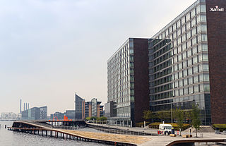
WNordhavnen, or Nordhavn, is a harbour area at the coast of the Øresund, founded at the end of the 19th century in Copenhagen, Denmark. It covers an area of more than 2 km².
 W
WNørrebro is one of the 10 official districts of Copenhagen, Denmark. It is northwest of the city centre, beyond the location of the old Northern Gate (Nørreport), which, until dismantled in 1856, was near the current Nørreport station.
 W
WRyparken is an area in the northern part of Østerbro, Copenhagen. Close to the ethnic and diverse neighborhood of Nørrebro, yet still in the 2100 Østerbro zip code, Ryparken defies easy definition. The area is well connected both by buses and by the S-train Ryparken station, formerly known as Lyngbyvej station until 1972.
 W
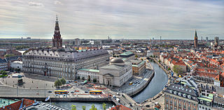
WSlotsholmen is an island in the harbour of Copenhagen, Denmark, and part of Copenhagen Inner City. The name is taken from the successive castles and palaces located on the island since Bishop Absalon constructed the city's first castle on the island in 1167 at the site where Christiansborg Palace lies today.
 W
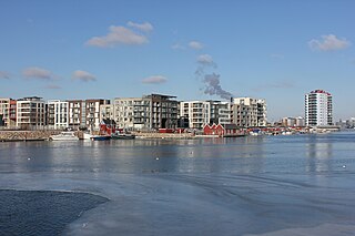
WSluseholmen is an artificial peninsula in the South Harbour of Copenhagen, Denmark. It takes its name from Slusen, a lock immediately to the south, regulating water levels in the harbor. Previously the site of heavy industry and part of the Southern Docklands of Port of Copenhagen, Sluseholmen has, since the turn of the millennium, undergone massive redevelopment, transforming it into a mainly residential district known for its canals and maritime atmosphere. It is connected to Teglholmen by the Teglværk Bridge.
 W
WSundbyøster is one of the 15 administrative, statistical, and tax city districts (bydele) comprising the municipality of Copenhagen, Denmark. It lies on the southeast border of the municipality on the island of Amager. It covers an area of 8.60 km², has a population of 48,673 and a population density of 5,658 per km², which makes it the most populated district in Copenhagen.
WSundbyvester is one of the 15 administrative, statistical, and tax city districts (bydele) comprising the municipality of Copenhagen, Denmark. It lies on the south border of the municipality on the island of Amager. It covers an area of 5.21 km², has a population of 38,017 and a population density of 7,302 per km².
 W
WTeglholmen is a peninsula in the South Harbour of Copenhagen, Denmark, located between Sluseholmen and Enghave Brygge. The former dockland area used to house heavy industry. While some industry activities remain in the area, but since most industry left the area, starting in the 1970s, it has undergone massive redevelopment, though some industrial activities remain, most notably MAN B&W Diesel's motor development plant. Today the area houses both a considerable number of Danish and regional headquarters of multinational companies and residential developments. Teglholmen is home to Aalborg University's AAU Cph Campus as well as TV 2's activities in Copenhagen.
 W
WUtterslev is a neighbourhood in the Bispebjerg district of Copenhagen, Denmark. Utterslev is centered on Utterslev Torv and is most known for the Utterslev Mose marshland which straddles the border with Gladsaxe Municipality to the north.
 W
WValby (help·info) is one of the 10 official districts of Copenhagen, Denmark. It is in the southwestern corner of Copenhagen Municipality, and has a mixture of different types of housing. This includes apartment blocks, terraced housing, areas with single-family houses and allotments, plus the remaining part of the old Valby village, around which the district has formed, intermingled with past and present industrial sites.
WVanløse is one of the 10 official districts of Copenhagen, Denmark. It lies on the western border of the municipality. Vanløse covers an area of 6.69 km², and has a population of 36,115, making Vanløse the smallest district of Copenhagen, by population.
WVestamager most often refers to Kalvebod Fælled, but is also the name of one of the 15 administrative, statistical, and tax city districts (bydele) comprising the municipality of Copenhagen, Denmark. It lies on the south border of the municipality on the island of Amager. It covers an area of 13.99 km², has a population of 7,799 and a population density of 558 per km², making it both the largest district in area and the least densely populated district in Copenhagen.
 W
WVesterbro is one of the 15 administrative, statistical, and city tax districts (bydele) comprising the municipality of Copenhagen, Denmark. It covers an area of 3.76 km², and has a population of 51,466 and a population density of 13,688 per km².