 W
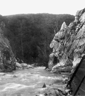
WThe Arroyo Seco, meaning "dry stream" in Spanish, is a 24.9-mile-long (40.1 km) seasonal river, canyon, watershed, and cultural area in Los Angeles County, California. The area was explored by Gaspar de Portolà who named the stream Arroyo Seco as this canyon had the least water of any they had seen. During this exploration he met the Chief Hahamog-na (Hahamonga) of the Tongva Indians.
 W
WThe Baldwin Hills are a low mountain range surrounded by and rising above the Los Angeles Basin plain in central Los Angeles County, California. The Pacific Ocean is to the west, the Santa Monica Mountains to the north, Downtown Los Angeles to the northeast, and the Palos Verdes Hills to the south - with all easily viewed from the Baldwin Hills.
 W
WBallona Creek is an 8.8-mile-long (14.2 km) urbanized river in southwestern Los Angeles County, California, whose watershed includes a portion of the western Los Angeles basin, from the Santa Monica Mountains on the north, the Harbor Freeway (I-110) on the east, and the Baldwin Hills on the south.
 W
WBell Creek is a 10-mile-long (16 km) tributary of the Los Angeles River, in the Simi Hills of Ventura County and the San Fernando Valley of Los Angeles County and City, in Southern California.
 W
WThe Beverly Hills Oil Field is a large and currently active oil field underneath part of the city of Beverly Hills, California, USA, and portions of the adjacent city of Los Angeles. Discovered in 1900, and with a cumulative production of over 150 million barrels of oil, it ranks 39th by size among California's oil fields, and is unusual for being a large, continuously productive field in an entirely urban setting. All drilling, pumping, and processing operations for the 97 currently active wells are done from within four large "drilling islands", visible on Pico and Olympic Boulevards as large windowless buildings, from which wells slant diagonally into different parts of the producing formations, directly underneath the multimillion-dollar residences and commercial structures of one of the wealthiest cities in the United States. Annual production from the field was 1.09 million barrels in 2006, 966,000 barrels in 2007, and 874,000 in 2008, and the field retains approximately 11 million barrels of oil in reserve, as estimated by the California Department of Conservation. The largest operators as of 2009 were independent oil companies Plains Exploration & Production and BreitBurn Energy.
 W
WCabrillo Beach is a historic public beach located in San Pedro, Los Angeles, California. It is named after Juan Rodríguez Cabrillo, a Portuguese explorer who was the first to sail up the California coast. Cabrillo has two separate beach areas.
 W
WCortes Bank is a shallow seamount in the North Pacific Ocean. It is 96 miles southwest of San Pedro, Los Angeles, 111 miles west of Point Loma, San Diego, and 47 miles southwest of San Clemente Island in Los Angeles County. It is considered the outermost feature in California's Channel Islands chain. At various times during geologic history, the bank has been an island, depending on sea level rise and fall. The last time it was a substantial island was around 10,000 years ago during the last ice age. It is possible that this island was visited by the first human inhabitants of the Channel Islands, most notably San Clemente Island, whose seafaring residents would have been able to see the island from high elevations on clear days.
 W
WThe Crescenta Valley is a small inland valley in Los Angeles County, California, lying between the San Gabriel Mountains on the northeast and the Verdugo Mountains and San Rafael Hills on the southwest. It opens into the San Fernando Valley at the northwest and the San Gabriel Valley at the southeast. It is nearly bisected by the Verdugo Wash, a smaller valley separating the Verdugo Mountains from the San Rafael Hills. Most of the valley lies at an elevation of over 1,500 feet.
 W
WEl Escorpión Park is a three-acre park located in the Simi Hills of the western San Fernando Valley, in the West Hills district of Los Angeles, California. The park contains the geographic landmark known as Escorpión Peak or Castle Peak, a 1,475-foot-tall rocky peak seen from most parts of the park and the surrounding community.
 W
WFort Moore was the second of two historic U.S. Military Forts in Los Angeles, California, during the Mexican–American War. It lay straight above the junction of the Hollywood Freeway and Broadway, on an historic hill that once sheltered the old Plaza.
 W
WThe Glendale Narrows is a scenic 11 mile section of the Los Angeles River in the Northeast Los Angeles region of Los Angeles County, California.
 W
WThe Inglewood Oil Field in Los Angeles County, California, is the 18th-largest oil field in the state and the second-most productive in the Los Angeles Basin. Discovered in 1924 and in continuous production ever since, in 2012 it produced approximately 2.8 million barrels of oil from some five hundred wells. Since 1924 it has produced almost 400 million barrels, and the California Department of Oil, Gas and Geothermal Resources (DOGGR) has estimated that there are about 30 million barrels remaining in the field's one thousand acres, recoverable with present technology.
 W
WThe Los Angeles City Oil Field is a large oil field north of Downtown Los Angeles. Long and narrow, it extends from immediately south of Dodger Stadium west to Vermont Avenue, encompassing an area of about four miles long by a quarter-mile across. Its former productive area amounts to 780 acres (3.2 km2).
 W
WThe Los Angeles Harbor Region is in Los Angeles County, California.
 W
WThe Los Angeles River is a major river in Los Angeles County, California. Its headwaters are in the Simi Hills and Santa Susana Mountains, and it flows nearly 51 miles (82 km) from Canoga Park through the San Fernando Valley, Downtown Los Angeles, and the Gateway Cities to its mouth in Long Beach. While the river was once free-flowing and frequently flooding, forming alluvial flood plains along its banks, it is currently notable for flowing through a concrete channel on a fixed course, which was built after a series of devastating floods in the early 20th century.
 W
WMount Lukens is a mountain peak of the San Gabriel Mountains, in Los Angeles County, Southern California.
 W
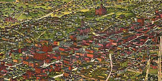
WThe late-Victorian-era Downtown of Los Angeles grew year by year, around 1880 centered at the southern end of the Los Angeles Plaza area, and over the next two decades, extending south and west along Main Street, Spring Street, and Broadway towards Third Street. Most of the 19th-century buildings no longer exist, surviving only in the Plaza area or south of Second Street. The rest were demolished to make way for the Civic Center district with City Hall, numerous courthouses, and other municipal, county, state and federal buildings, and Times Mirror Square. This article covers that area, between the Plaza, 3rd St., Los Angeles St., and Broadway, during the period 1880 through the period of demolition (1920s–1950s).
 W
WThe Rio Hondo is a tributary of the Los Angeles River in Los Angeles County, California, approximately 16.4 miles (26.4 km) long. As a named river, it begins in Irwindale and flows southwest to its confluence in South Gate, passing through several cities. Above Irwindale its main stem is known as Santa Anita Creek, which extends another 10 miles (16 km) northwards into the San Gabriel Mountains where the source, or headwaters, of the river are found.
WThe Rosecrans Hills are a low range of hills in the Transverse Ranges, in the South Los Angeles region of Los Angeles County, California.
 W
WSan Pedro Bay is an inlet on the Pacific Ocean coast of southern California, United States. It is the site of the Port of Los Angeles and the Port of Long Beach, which together form the fifth-busiest port facility in the world and the busiest in the Americas. The community of San Pedro, Los Angeles borders a small portion on the western side of the bay, and shares the name. The city of Long Beach borders the port on the eastern side of the bay. The northern part of the bay which is the largest part of the port is bordered by the community of Wilmington in the city of Los Angeles.
WThe San Rafael Hills are a mountain range in Los Angeles County, California. They are one of the lower Transverse Ranges, and are parallel to and below the San Gabriel Mountains, adjacent to the San Gabriel Valley overlooking the Los Angeles Basin.
 W
WSanta Monica Bay is a bight of the Pacific Ocean in Southern California, United States. Its boundaries are slightly ambiguous, but it is generally considered to be the part of the Pacific within an imaginary line drawn between Point Dume, in Malibu, and the Palos Verdes Peninsula. Its eastern shore forms the western boundary of the Los Angeles Westside and South Bay regions. Although it was fed by the Los Angeles River prior to the river's catastrophic change of course in 1825, the only stream of any size now flowing into it is Ballona Creek. Other waterways draining into the bay include Malibu Creek, Topanga Creek, and Santa Monica Creek.
WThe Silver Lake Reservoir Complex comprise two concrete-lined basins, Ivanhoe Reservoir and Silver Lake, divided by a spillway, in the Silver Lake community of Los Angeles, California.
 W
WThe studio zone, also known as the thirty-mile zone (TMZ), is an area proscribed by a 30-mile (48 km) radius of "Hollywood" used by the American entertainment industry to determine employee benefits for filmwork done within it. Its center has traditionally been regarded as the southwest corner of West Beverly Boulevard and North La Cienega Boulevard in Los Angeles, California. The boundaries of the 30-mile radius includes almost all of the southern half of Los Angeles County, as well as parts of eastern Ventura County and northwestern Orange County.
 W
WThe Venice Canal Historic District is embedded in the residential Venice suburb of Los Angeles, California. The historic district is noteworthy for possessing man-made wetland canals, built in 1905 by developer Abbot Kinney as part of his Venice of America. Kinney sought to recreate the appearance and feel of Venice, Italy, in coastal Los Angeles County. The names of the canals were given by Abbot Kinney as follows: Aldebaren Canal, Altair Canal, Cabrillo Canal, Coral Canal, Grand Canal, Lion Canal and Venus Canal.
 W
WThe Verdugo Mountains are a small, rugged mountain range of the Transverse Ranges system, located just south of the western San Gabriel Mountains in Los Angeles County, Southern California. The range is sometimes known as the Verdugo Hills or simply the Verdugos.
 W
WThe Wilmington Oil Field is a prolific petroleum field in Los Angeles County in southern California in the United States. Discovered in 1932, it is the third largest oil field in the United States in terms of cumulative oil production. The field runs roughly southeast to northwest through the Los Angeles Basin, stretching from the middle of San Pedro Bay through Long Beach and east of the Palos Verdes Peninsula. The field originally contained approximately at least some 3 billion barrels (480,000,000 m3) of reserves. In 2013, the USGS estimated future potential production from the combined Wilmington-Belmont oilfield could be around 900 million barrels (140,000,000 m3).