 W
WThe geography of Scotland is varied, from rural lowlands to unspoilt uplands, and from large cities to sparsely inhabited islands. Located in Northern Europe, Scotland comprises the northern half of the island of Great Britain as well as 790 surrounding islands encompassing the major archipelagos of the Shetland Islands, Orkney Islands and the Inner and Outer Hebrides.
 W
WThe Anglo-Scottish border runs for 96 miles (154 km) between Marshall Meadows Bay on the east coast and the Solway Firth in the west.
 W
WIn Scottish geography, a Carse is an area of fertile, low-lying land occupying certain Scottish river valleys, such as that of the River Forth.
 W
WThe Central Belt of Scotland is the area of highest population density within Scotland. Depending on the definition used, it has a population of between 2.4 and 4.2 million covering an area of approximately 10,000 km2, including Greater Glasgow, Ayrshire, Falkirk, Edinburgh, Lothian and Fife.
 W
W W
WA dun is an ancient or medieval fort. In Ireland and Britain it is mainly a kind of hillfort and also a kind of Atlantic roundhouse. The term comes from Irish dún or Scottish Gaelic dùn, and is cognate with Old Welsh din.
 W
WElderslie Rock is a geological intrusion of hard whinstone rock which extends across and beneath the River Clyde near Glasgow, Scotland. It represented a significant hazard to shipping until large sections were blasted to an eventual depth of 28 feet in the nineteenth and early twentieth centuries, at a high cost and using then-innovative techniques.
 W
WThe Gàidhealtachd usually refers to the Highlands and Islands of Scotland and especially the Scottish Gaelic-speaking culture of the area. The corresponding Irish word Gaeltacht refers strictly to Irish-speaking areas.
 W
WGlen Lean is on the Cowal peninsula in Argyll and Bute, Scotland. It is an obvious glacial-formed glen, with near vertical sides along part of the glen. It runs from the head of the Holy Loch in the east to the head of Loch Striven in the west. The only hamlet in the glen is Clachaig. The Little Eachaig River flows out of the glen, joining the River Eachaig and flows into the Holy Loch. The Tarsan Dam is the other notable feature in the glen.
 W
WThe Highlands and Islands of Scotland are broadly the Scottish Highlands, plus Orkney, Shetland and the Western Isles.
 W
WThe Inner Seas off the West Coast of Scotland is a marine area designated by the International Hydrographic Organization (IHO). It consists of a number of waterbodies between the Scottish mainland, the Outer Hebrides islands, and the coast of Ireland.
 W
WLamberton Skerrs is the southernmost point on the east coast of Scotland. It was the scene of a building known as the "Smuggler's Bothy" which was built by the famous smuggler John Robertson in about 1760 and stands on the cliffs overlooking the North Sea. He smuggled tea and was in partnership with a Swedish shipping line. The cover for the operation was fishing but the building was actually later used as a fishery cottage. It was eventually destroyed by vandals who set it alight. A rusted net winch and storage caves built into the rocks are all that remains of the fishery.
 W
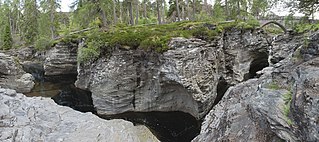
WIn Scotland and northern England a Linn is a geographical water feature, a watercourse that has cut through a shelf of hard rock creating a narrow (usually), steep-sided crevice (fracture) though which it runs.
 W
WLoch Beag is a cove on the west coast of Northern Scotland, in the vicinity of the Sound of Arisaig. The western end of the Sound of Arisaig divides into Loch nan Uamh in the north and Loch Ailort in the south separated by a headland. Loch Beag is an inlet at the eastern end of Loch nan Uamh. It is 1.2 kilometres (0.75 mi) long and 0.5 kilometres (0.31 mi) wide, with a maximum depth of 21 metres (69 ft).
 W
WNorthern Scotland was an administrative division of Scotland used for police and fire services. It consisted of Highland, the Orkney Islands, the Shetland Islands, and the Western Isles. The police service used Northern in its name, but the fire service used the name Highlands and Islands Fire and Rescue Service. In 2013, the services were merged into Police Scotland and the Scottish Fire and Rescue Service, respectively.
 W
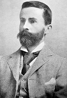
WFrancis Hindes Groome, son of Robert Hindes Groome, Archdeacon of Suffolk. A writer and foremost commentator of his time on the Romani people, their language, life, history, customs, beliefs, and lore.
 W
WThe Pass of Brander is a mountain pass in the Highlands of Scotland, where the main railway and road to Oban makes its way between Cruachan, a 3,689 ft mountain, and Loch Awe.
 W
WPuck's Glen is a river-formed ravine on the Cowal peninsula in Argyll and Bute, Scotland, with a popular scenic walking trail beside the Eas Mòr stream. In 2020 the glen and adjoining trails were closed temporarily due to COVID-19 restrictions, issues of stability of the gorge, and felling of trees infected by larch disease.
 W
WThe Rockall Trough is a deep-water bathymetric feature to the northwest of Scotland and Ireland, running roughly from southwest to northeast, flanked on the north by the Rockall Plateau and to the south by the Porcupine Seabight. At the northern end, the channel is bounded by the Wyville-Thomson Ridge, named after Charles Wyville Thomson, professor of zoology at the University of Edinburgh and driving force behind the Challenger Expedition. At the southern end, the trough opens into the Porcupine abyssal plain. The Rockall Basin is a large sedimentary basin that lies beneath the trough. Both are named after Rockall, a rocky islet lying 301.4 km west of St Kilda.
 W
WA royal burgh was a type of Scottish burgh which had been founded by, or subsequently granted, a royal charter. Although abolished in law in 1975, the term is still used by many former royal burghs.
 W
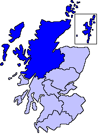
WThe Highlands is a historic region of Scotland. Culturally, the Highlands and the Lowlands diverged from the later Middle Ages into the modern period, when Lowland Scots replaced Scottish Gaelic throughout most of the Lowlands. The term is also used for the area north and west of the Highland Boundary Fault, although the exact boundaries are not clearly defined, particularly to the east. The Great Glen divides the Grampian Mountains to the southeast from the Northwest Highlands. The Scottish Gaelic name of A' Ghàidhealtachd literally means "the place of the Gaels" and traditionally, from a Gaelic-speaking point of view, includes both the Western Isles and the Highlands.
WThe Lowlands is a cultural and historical region of Scotland. Culturally, the Lowlands and the Highlands diverged from the later Middle Ages into the modern period, when Lowland Scots replaced Scottish Gaelic throughout most of the Lowlands.
 W
WScottish toponymy derives from the languages of Scotland. The toponymy varies in each region, reflecting the linguistic history of each part of the country.
 W
WIt is a central tenet of the EU maritime policy that all seas have a particular nature, defined by their geography, their ecology, their economies and their people. Most seas are nested and do not, except for specific purposes such as hydrography or fisheries management, have sharp, recognised boundaries. One important sea for purposes of fisheries management is referred to as the "seas West of Scotland". In line with the EU maritime policy, the sea does not only encompass the waters but also the people and economy of the areas bordering that sea.
 W
WThe Southern Uplands are the southernmost and least populous of mainland Scotland's three major geographic areas. The term is used both to describe the geographical region and to collectively denote the various ranges of hills and mountains within this region. An overwhelmingly rural and agricultural region, the Southern Uplands are partly forested and contain many areas of open moorland.
 W
WSròn is the Scottish Gaelic word for nose and is the name of some hills in the Scottish Highlands. Before the abolition of the acute accent in Scottish Gaelic, it was sometimes spelt as srón.
 W
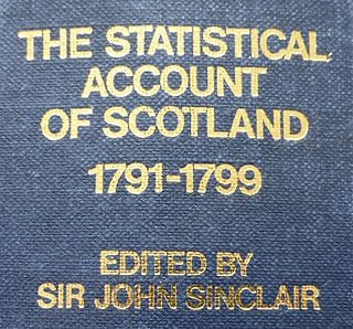
WThe Statistical Accounts of Scotland are a series of documentary publications, related in subject matter though published at different times, covering life in Scotland in the 18th, 19th and 20th centuries.