 W
WRothwell is a market town in the south-east of the City of Leeds metropolitan borough in West Yorkshire, England. It is situated between Leeds and Wakefield.
 W
WCarlton is a village in the south of the City of Leeds metropolitan borough in West Yorkshire, England, about 6 miles (13 km) from Leeds city centre.
 W
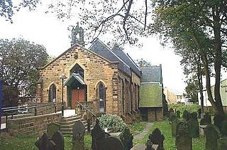
WThe Holy Trinity Church in Rothwell, West Yorkshire, England is an active Anglican parish church in the archdeaconry of Leeds and the Diocese of Leeds.
 W
WLofthouse is a village between the cities of Wakefield and Leeds in West Yorkshire, England. The village falls within the Ardsley and Robin Hood ward of the City of Leeds Council. It is in the City of Leeds metropolitan borough but with a Wakefield postal address (WF3). It is mentioned as Locthuse, also as Loftose in the 1086 Domesday Book.
 W
WLower Mickletown is a hamlet in the City of Leeds, in the English county of West Yorkshire. It was named Low Mickletown in the early 20th century and has been known under this name at least until about 1950.
 W
WMethley is a dispersed village in the City of Leeds metropolitan borough, south east of Leeds, West Yorkshire, England. It is located near Rothwell, Oulton, Woodlesford, Mickletown and Allerton Bywater. The Leeds City Ward is called Kippax and Methley. It is within the triangle formed by Leeds, Castleford and Wakefield, and between the confluence of the River Aire and River Calder. The latter is crossed by Methley Bridge, the A639 road, about a mile south-east of the village.
WMethley is a dispersed village in the City of Leeds metropolitan borough, south east of Leeds, West Yorkshire, England. It is located near Rothwell, Oulton, Woodlesford, Mickletown and Allerton Bywater. The Leeds City Ward is called Kippax and Methley. It is within the triangle formed by Leeds, Castleford and Wakefield, and between the confluence of the River Aire and River Calder. The latter is crossed by Methley Bridge, the A639 road, about a mile south-east of the village.
 W
WMethley Junction railway station was one of three stations that served the village of Methley, West Yorkshire, England. It opened on 1 October 1849 and closed on 4 October 1943.
 W
WMethley railway station was opened in 1841 by the North Midland Railway on its line from Derby to Leeds. At one time, there were three railway stations in Methley and in 1950, British Railways renamed it Methley North. It closed in 1957.
 W
WMethley South railway station was one of three stations that served the village of Methley, West Yorkshire, England.
 W
WMickletown is a district within the village of Methley, south of Leeds, West Yorkshire, England.
 W
WOulton Hall in Oulton, West Yorkshire, England is a Grade II listed building. It was once the home of the Blayds/Calverley family. After a major fire in 1850 the hall was remodelled, but its fortunes declined until it was revived for use as a hotel. It is now a 4 star hotel, part of the QHotels group.
 W
WOulton is a village in the City of Leeds metropolitan borough, West Yorkshire, England, between Leeds and Wakefield. It is at the junction of the A639 and A642 roads. Though now adjoining the village of Woodlesford, it was once quite separate.
 W
WThe Rhubarb Triangle is a 9-square-mile (23 km2) area of West Yorkshire, England between Wakefield, Morley and Rothwell famous for producing early forced rhubarb. It includes Kirkhamgate, East Ardsley, Stanley, Lofthouse and Carlton. The Rhubarb Triangle was originally much bigger, covering an area between Leeds, Bradford and Wakefield. From the 1900s to 1930s, the rhubarb industry expanded and at its peak covered an area of about 30 square miles (78 km2).
 W
WRobin Hood is a village in West Yorkshire, England, within the City of Leeds metropolitan borough, with Wakefield WF3 postcodes. It is on the A61 between Leeds and Wakefield, close to Rothwell and Lofthouse.
 W
WThe Rodillian Academy is a mixed secondary School and sixth form with academy status located in Lofthouse, West Yorkshire, England. The school has 1,556 pupils aged between 11 and 18. The school also has Specialist Arts College status. The name 'Rodillian' is derived from the name that was given to former pupils of the Rothwell Grammar School.
 W
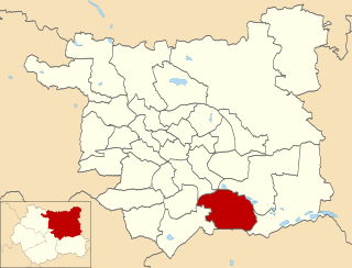
WRothwell is an electoral ward of Leeds City Council in south east Leeds, West Yorkshire, including the town of the same name and the villages of Carlton, Oulton and Woodlesford.
WRothwell is a market town in the south-east of the City of Leeds metropolitan borough in West Yorkshire, England. It is situated between Leeds and Wakefield.
WRothwell is a market town in the south-east of the City of Leeds metropolitan borough in West Yorkshire, England. It is situated between Leeds and Wakefield.
 W
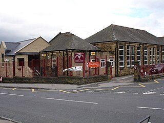
WRoyds School, founded in 1956, is a secondary school located in Leeds, West Yorkshire, England. The school serves approximately 1,300 pupils. Royds School was originally a secondary modern and is now a non-selective comprehensive serving Rothwell, south Leeds and the surrounding areas. The school originally gained Specialist Language College status in 2003. This was removed in 2014.
 W
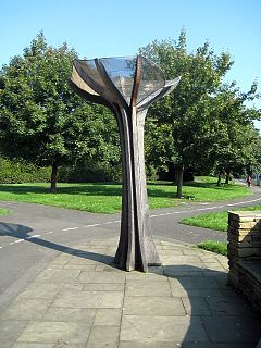
WSpringhead Park is the premier park in Rothwell, West Yorkshire, England.
 W
WSt John the Evangelist's Church, Oulton, West Yorkshire, England is an active Anglican parish church in the archdeaconry of Leeds and the Diocese of Leeds.
 W
WStourton is a mainly industrial area of the city of Leeds, West Yorkshire, England. The area falls within the City and Hunslet ward of Leeds Metropolitan Council.
 W
WThorpe on the Hill is a small village in West Yorkshire, England. The village falls within the Ardsley and Robin Hood ward of the Leeds Metropolitan Council. It was mentioned as "Torp" in the Domesday Book together with neighbouring Carlton, Lofthouse, Middleton, and Rothwell as part of the Morley Hundred in the West Riding.
The West Riding County Football Association is the governing body of football in the area covered by the historic West Riding of Yorkshire. Its headquarters are in the village of Woodlesford, six miles south east of Leeds. Affiliated members pay a fee commensurate with the level of competition they play in. Affiliated members benefit from access to support and guidance on such areas as health and safety and access to finance or grants. The County FA is directly responsible for the governance of County Cup competitions.
 W
WWoodlesford is a suburban village in the City of Leeds, West Yorkshire, England, 6 miles (10 km) south-east of Leeds city centre. Formerly part of the Rothwell Urban District, it is now within the Rothwell ward of Leeds City Council. The village sits on the banks of the Aire and Calder Navigation and river system.
 W
WWoodlesford railway station serves Woodlesford and Rothwell in West Yorkshire, England. It lies on the Hallam Line and the Pontefract Line, 6 miles (9.7 km) south of Leeds.