 W
WBulmer Cavern is New Zealand's longest cave system, running for 66 km through Mount Owen in the Tasman region of the northwest South Island. John Patterson discovered the cave on New Year's Day 1984, by dropping a rock down and counting the seconds until it reached the bottom.
 W
WCape Farewell is a headland in New Zealand, the most northerly point on the South Island. It is located just west of Farewell Spit. First mapped by Abel Tasman, it was named by British explorer Captain James Cook in 1770 —it was the last land seen by his crew as they departed on the ship's homeward voyage.
 W
WHoneycomb Hill Cave is located in the Oparara Basin, on the northwestern edge of the South Island of New Zealand. The Oparara River flows through a section of the cave.
WHope, previously known as Ranzau, is a small settlement south of Nelson, New Zealand, between Richmond and Wakefield.
WKahurangi Point is a headland on the West Coast of New Zealand's South Island, overlooking the Tasman Sea. It is located in Kahurangi National Park between Karamea and Farewell Spit.
 W
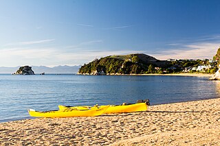
WKaiteriteri is a town and seaside resort in the Tasman Region of the South Island of New Zealand. It is close to both Marahau, the main gateway to Abel Tasman National Park, and the township of Motueka.
 W
WRotopōhueroa / Lake Constance is an alpine lake in the South Island of New Zealand.
 W
WLake Matiri is a lake adjoining Kahurangi National Park in the northwest corner of New Zealand's South Island. The lake is part of the Matiri River.
 W
WLake Rotoiti, previously also known as Lake Arthur, is a lake in the Tasman Region of New Zealand. It is a substantial mountain lake within the borders of Nelson Lakes National Park. The lake is fed by the Travers River, water from the lake flows into the Buller River. The lake is surrounded by Beech forest and is 82 metres deep. Saint Arnaud is a small community at the northern end of the lake.
 W
WLake Sparrow is a mountain tarn in New Zealand's Anatoki Range. It is located within Kahurangi National Park in the South Island's Tasman Region. It lies at an elevation of some 1,400 metres (4,600 ft), and covers approximately 4 hectares.
 W
WMārahau is a very small town in the Tasman Region of the South Island of New Zealand, approximately 19 kilometres (12 mi) north of Motueka. Its location on Tasman Bay and at the southern entrance of Abel Tasman National Park makes it a popular holiday destination for those keen on outdoor activities. People access the Abel Tasman from Mārahau by tramping, kayaking and water taxi. In Mārahau itself, the beach offers sheltered and safe swimming, and horse trekking is popular throughout the busy summer season.
 W
WMount Arthur is in the Arthur Range in the north western area of the South Island of New Zealand. Mount Arthur, named after Captain Arthur Wakefield, lies within Kahurangi National Park and has a peak elevation of 1,795 metres (5,889 ft).
 W
WPourangahau / Mount Robert is a 1,421m high mountain in the Nelson area of New Zealand's South Island. It is within the Nelson Lakes National Park. For many years Mt Robert formed part of John Kerr of Nelson's, Lake Station but was returned to the crown in the years following his death in 1898. The partially unsealed Mt Robert Road, just west of the town of Saint Arnaud leads to a car park that is the start of tramping tracks into the Nelson Lakes National Park, and also a 5-hour loop walk up the mountain: The Pinchgut Track zigzags steeply up to near the top of Mt Robert, then continues along a ridge to Bushline Hut, before descending via the more gentle Paddy's Track. The track offers view over Lake Rotoiti and St Arnaud.
 W
WThe Ngārua Caves are a series of limestone caves in the Takaka Hill range south of Abel Tasman National Park.
WMount Owen is in the Tasman district of the South Island of New Zealand. It stands at 1875 metres (6150 feet) above sea level and is part of the Marino Mountains.
 W
WThe tiny settlement of Pūponga in New Zealand is the northernmost settlement in the South Island. It is in the Tasman District, 18 kilometres (11 mi) north of Collingwood, at the foot of Farewell Spit. The spit's airstrip, Triangle Flat Airstrip is just northeast of Puponga.
 W
WRiwaka is a small settlement in the Tasman District of New Zealand's South Island. It lies beside Tasman Bay, five kilometres north of Motueka, and close to the mouth of the Riuwaka River. As of 2006 it had a population of 549 people.
 W
WLake Rotoroa lies within the borders of Nelson Lakes National Park in the South Island, New Zealand. The lake is fed by the D'Urville and Sabine rivers.
 W
WThe Saint Arnaud Range is a mountain range in the central north of New Zealand's South Island. It lies between Lake Rotoiti and the upper reaches of the Wairau River, and marks the eastern boundary of Nelson Lakes National Park.
 W
WThe Spenser Mountains is a topographic landform in the northern South Island of New Zealand. Located at the southern end of the Nelson Lakes National Park and north of the Lewis Pass they form a natural border between the Canterbury and Tasman regions. Several peaks are named after characters in Edmund Spenser’s allegorical poem, The Faerie Queene. Many of the early explorers were evidently literate men. For example, Frederick Weld named Lake Tennyson; William Travers named the Spensers and Faerie Queene; Julius Haast named Mt Una.
 W
WTākaka Hill is a range of hills in the northwest of the South Island of New Zealand. Made of marble that has weathered into many strange forms and with numerous sink holes, it is typical karst country. The marble is Ordovician in age and from the Takaka Terrane.
 W
WTapawera is a small town in New Zealand's South Island. It is located 30 kilometres (19 mi) southwest of Nelson by the banks of the Motueka River. The population including the surrounding area was 396 in the 2013 census, a decrease of nine from 2006. The town is a gateway to the Kahurangi National Park.
 W
WTasman District Council is the unitary local authority for the Tasman District of New Zealand.
 W
WTata / Near Beach is a beach and small coastal settlement of predominantly holiday houses in the South Island, New Zealand. Found in the Golden Bay region, it is approximately 20 kilometres (12 mi) north-east of Takaka.
 W
WTonga Island is a small (0.15 km2) island in Tasman Bay, off the northern coast of the South Island of New Zealand. It lies within the Abel Tasman National Park, about 1 kilometre (0.62 mi) off Onetahuti Beach. The island has a flourishing fur seal colony, and is surrounded by the Tonga Island Marine Reserve, which was inaugurated in 1993.
 W
WWainui Bay is within Golden Bay, and at the south-eastern end of Golden Bay, in the Tasman Region of the South Island, New Zealand. Bordering the Abel Tasman National Park, it is approximately 24 kilometres (15 mi) north-east of Takaka, the nearest town. There are several Department of Conservation walking tracks that start in Wainui Bay, including the Wainui Falls track, the Taupo Point track, and other tracks leading into the Abel Tasman National Park.
 W
WWhanganui Inlet is a large natural indentation in the northwest coast of the South Island of New Zealand.