 W
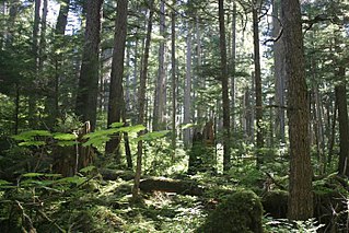
WThe Appalachian temperate rainforest is located in the southern Appalachian Mountains of the eastern U.S. About 351,500 square kilometers of forest land is spread across southwestern Virginia, western North Carolina, the tip of South Carolina, northern Georgia, and eastern Tennessee. The annual precipitation is more than 60 inches. The Southern Appalachian spruce–fir forest is a temperate rainforest located in the higher elevations in southwestern Virginia, western North Carolina and East Tennessee. Fir is dominant at higher elevation, spruce at middle elevation, and mixed forests at low elevation.
 W
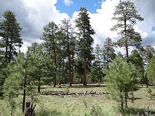
WThe Arizona Mountains forests are a temperate coniferous forests ecoregion of the southwest United States with a rich variety of woodland habitats and wildlife.
 W
WThe Atlantic coastal pine barrens is a now rare temperate coniferous forest ecoregion of the Northeast United States distinguished by unique species and topographical features, generally nutrient-poor, often acidic soils and a pine tree distribution once naturally controlled by frequent fires.
 W
WThe Blue Mountains ecoregion is a Level III ecoregion designated by the United States Environmental Protection Agency (EPA) in the Pacific Northwest, mainly in the state of Oregon, with small areas over the state border in Idaho and southeastern Washington. It is also contiguous with the World Wildlife Fund's Blue Mountain forests ecoregion.
 W
WThe Cascade Mountains leeward forests are a temperate coniferous forest ecoregion of North America, as defined by the World Wildlife Fund (WWF) categorization system.
 W
WThe Cascades ecoregion is a Level III ecoregion designated by the United States Environmental Protection Agency (EPA) in the U.S. states of Washington, Oregon, and California. Somewhat smaller than the Cascade mountain range for which it is named, the ecoregion extends north to Snoqualmie Pass, near Seattle, and south to Hayden Pass, near the Oregon-California border, including the peaks and western slopes of most of the High Cascades. A discontiguous section is located on Mount Shasta in California.
WThe Cascades ecoregion is a Level III ecoregion designated by the United States Environmental Protection Agency (EPA) in the U.S. states of Washington, Oregon, and California. Somewhat smaller than the Cascade mountain range for which it is named, the ecoregion extends north to Snoqualmie Pass, near Seattle, and south to Hayden Pass, near the Oregon-California border, including the peaks and western slopes of most of the High Cascades. A discontiguous section is located on Mount Shasta in California.
WThe Cascades ecoregion is a Level III ecoregion designated by the United States Environmental Protection Agency (EPA) in the U.S. states of Washington, Oregon, and California. Somewhat smaller than the Cascade mountain range for which it is named, the ecoregion extends north to Snoqualmie Pass, near Seattle, and south to Hayden Pass, near the Oregon-California border, including the peaks and western slopes of most of the High Cascades. A discontiguous section is located on Mount Shasta in California.
 W
WThe Eastern Cascades Slopes and Foothills ecoregion is a Level III ecoregion designated by the United States Environmental Protection Agency (EPA) in the U.S. states of Oregon, Washington, and California. In the rain shadow of the Cascade Range, the eastern side of the mountains experiences greater temperature extremes and receives less precipitation than the west side. Open forests of ponderosa pine and some lodgepole pine distinguish this region from the Cascades ecoregion, where hemlock and fir forests are more common, and from the lower, drier ecoregions to the east, where shrubs and grasslands are predominant. The vegetation is adapted to the prevailing dry, continental climate and frequent wildfire. Volcanic cones and buttes are common in much of the region.
 W
WFlorida sand pine scrub is an endangered subtropical forest ecoregion found throughout Florida in the United States. It is found on coastal and inland sand ridges and is characterized by an evergreen xeromorphic plant community dominated by shrubs and dwarf oaks. Because the low-nutrient sandy soils do not retain moisture, the ecosystem is effectively an arid one. Wildfires infrequently occur in the Florida scrub. Most of the annual rainfall falls in summer. It is endangered by residential, commercial and agricultural development, with the largest remaining block in and around the Ocala National Forest. Lake Wales Ridge National Wildlife Refuge also holds a high proportion of remaining scrub habitat, while the Archbold Biological Station near Lake Placid contains about 20 km2 (7.7 sq mi) of scrub habitat and sponsors biological research on it.
 W
WThe Great Basin montane forests is an ecoregion of the Temperate coniferous forests biome, as designated by the World Wildlife Fund (WWF).
 W
WThe Long Island Central Pine Barrens is a large area of publicly protected pine barrens in Suffolk County, New York, on Long Island, covering more than 100,000 acres (405 km2).
 W
WThe North Central Rockies forests is a temperate coniferous forest ecoregion of Canada and the United States. This region gets more rain on average than the South Central Rockies forests and is notable for containing the only inland populations of many species from the Pacific coast.
 W
WThe Northern California coastal forests are a temperate coniferous forests ecoregion of coastal Northern California.
 W
WThe Northern Pacific coastal forests are temperate coniferous forest ecoregion of the Pacific coast of North America. It occupies a narrow coastal zone of Alaska, between the Pacific Ocean and the northernmost Pacific Coast Ranges, covering an area of 23,300 square miles, extending from the Alexander Archipelago in southeast Alaska along the Gulf of Alaska to the western Kenai Peninsula and eastern Kodiak Island. The Pacific Coastal Mountain icefields and tundra ecoregion lies inland, at higher elevations in the Coast Mountains. The ecoregion receives high rainfall, which varies considerably based on exposure and elevation. It contains a quarter of the world's remaining temperate rain forest.
 W
WThe Pacific temperate rainforests ecoregion of North America is the largest temperate rain forest ecoregion on the planet as defined by the World Wildlife Fund. The Pacific temperate rain forests lie along the western side of the Pacific Coast Ranges along the Pacific Northwest Coast of North America from the Prince William Sound in Alaska through the British Columbia Coast to Northern California, and are part of the Nearctic realm, as also defined by the World Wildlife Fund. The Pacific temperate rain forests are characterized by a high amount of rainfall, in some areas more than 300 cm (10 ft) per year and moderate temperatures in both the summer and winter months.
 W
WThe Piney Woods is a temperate coniferous forest terrestrial ecoregion in the Southern United States covering 54,400 square miles (141,000 km2) of East Texas, southern Arkansas, western Louisiana, and southeastern Oklahoma. These coniferous forests are dominated by several species of pine as well as hardwoods including hickory and oak. Historically the most dense part of this forest region was the Big Thicket though the lumber industry dramatically reduced the forest concentration in this area and throughout the Piney Woods during the 19th and 20th centuries. The World Wide Fund for Nature considers the Piney Woods to be one of the critically endangered ecoregions of the United States. The United States Environmental Protection Agency (EPA) defines most of this ecoregion as the South Central Plains.
WThe Piney Woods is a temperate coniferous forest terrestrial ecoregion in the Southern United States covering 54,400 square miles (141,000 km2) of East Texas, southern Arkansas, western Louisiana, and southeastern Oklahoma. These coniferous forests are dominated by several species of pine as well as hardwoods including hickory and oak. Historically the most dense part of this forest region was the Big Thicket though the lumber industry dramatically reduced the forest concentration in this area and throughout the Piney Woods during the 19th and 20th centuries. The World Wide Fund for Nature considers the Piney Woods to be one of the critically endangered ecoregions of the United States. The United States Environmental Protection Agency (EPA) defines most of this ecoregion as the South Central Plains.
 W
WPonderosa shrub forest is a plant association and plant community found in western North America. It is found from the Rocky Mountains to the Pacific Coast Ranges in the Western United States and Western Canada.
 W
WThe Colorado Rockies forests is a temperate coniferous forest ecoregion of the United States.
 W
WThe South Central Rockies forests is a temperate coniferous forest ecoregion of the United States located mainly in Wyoming, Idaho, and Montana. It has a considerably drier climate than the North Central Rockies forest.
 W
WThe Rocky Mountain ponderosa pine forest is a forest plant community at an elevation of 2,100–2,700 metres (6,900–8,900 ft) in the Rocky Mountains, in the U.S. state of Colorado. It is an important temperate coniferous forest ecoregion, including some endemic wildlife and grass species that are only found in this ponderosa pine habitat.
 W
WThe Sierra Nevada lower montane forest is a plant community along a strip along the western and eastern edges of the Sierra Nevada mountain range in California. This zone is also known as a yellow pine forest.
 W
WThe Sierra Nevada upper montane forest is a vegetation type found below the treeline in the United States Sierra Nevada range. It is generally located above the mixed coniferous forest and below the alpine zone. Overstory trees are typically cone shaped to shed the snow.
 W
WThe Southeastern conifer forests are a temperate coniferous forest ecoregion of the southeastern United States. It is the largest conifer forest ecoregion east of the Mississippi River.
 W
WThe southern Appalachian spruce–fir forest is an ecoregion of the temperate coniferous forests biome, a type of montane coniferous forest that grows in the highest elevations in the southern Appalachian Mountains of the eastern United States.
 W
WThe Wasatch and Uinta montane forest is a temperate coniferous forest ecoregion in the Wasatch Range and Uinta Mountains of the western Rocky Mountains system, in the Western United States.