 W
WThe geology of India is diverse. Different regions of India contain rocks belonging to different geologic periods, dating as far back as the Eoarchean Era. Some of the rocks are very deformed and altered. Other deposits include recently deposited alluvium that has yet to undergo diagenesis. Mineral deposits of great variety are found in the Indian subcontinent in huge quantity. Even India's fossil record is impressive in which stromatolites, invertebrates, vertebrates and plant fossils are included. India's geographical land area can be classified into the Deccan Traps, Gondwana and Vindhyan.
 W
WAngadipuram Laterite is a notified National Geo-heritage Monument in Angadipuram town in Malappuram district in the southern Indian state of Kerala, India. The special significance of Angadipuram to laterites is that it was here that Dr. Francis Buchanan-Hamilton, a professional surgeon, gave the first account of this rock type, in his report of 1807, as "indurated clay", ideally suited for building construction. This formation falls outside the general classification of rocks namely, the igneous, metamorphic, or sedimentary rocks but is an exclusively "sedimentary residual product". It has a generally pitted and porous appearance. The name laterite was first coined in India, by Buchanan and its etymology is traced to the Latin word "letritis" that means bricks. This exceptional formation is found above parent rock types of various composition namely, charnockite, leptynite, anorthosite and gabbro in Kerala. It is found over basalt in the states of Goa, Maharashtra and in some regions of Karnataka. In Gujarat in western India, impressive formations of laterite are found over granite, shale and sandstone..
 W
WBugle Rock is a massive rock in the Basavanagudi area of South Bangalore, in the state of Karnataka. It is an abrupt rise above the ground of peninsular gneiss as the main rock formation and with an assessed age of about 3,000 million years. Bugle Rock has generated wide interest among the scientific community.
 W
WCharnockite, St. Thomas Mount, located to the south of the Chennai city, in Pallavaram suburb, Tamil Nadu, is a characteristically profuse exposure of quartz–feldspar–hypersthene rock, illustrated by occurrence of two pyroxene facies metamorphism.
 W
WThe Deccan Traps is a large igneous province of west-central India. They are one of the largest volcanic features on Earth. They consist of multiple layers of solidified flood basalt that together are more than 2,000 m (6,600 ft) thick, cover an area of c. 500,000 km2 (200,000 sq mi), and have a volume of c. 1,000,000 km3 (200,000 cu mi). Originally, the Deccan Traps may have covered c. 1,500,000 km2 (600,000 sq mi), with a correspondingly larger original volume.
 W
WThe Indian subcontinent has a history of devastating earthquakes. The major reason for the high frequency and intensity of the earthquakes is that the Indian plate is driving into Asia at a rate of approximately 47 mm/year. Geographical statistics of India show that almost 54% of the land is vulnerable to earthquakes. A World Bank and United Nations report shows estimates that around 200 million city dwellers in India will be exposed to storms and earthquakes by 2050. The latest version of seismic zoning map of India given in the earthquake resistant design code of India [IS 1893 2002] assigns four levels of seismicity for India in terms of zone factors. In other words, the earthquake zoning map of India divides India into 4 seismic zones unlike its previous version, which consisted of five or six zones for the country. According to the present zoning map, Zone 5 expects the highest level of seismicity whereas Zone 2 is associated with the lowest level of seismicity.
The Geological Survey of India (GSI) is a scientific agency of India. It was founded in 1851, is a Government of India Ministry of Mines organisation, one of the oldest of such organisations in the world and the second oldest survey in India after Survey of India, for conducting geological surveys and studies of India, and also as the prime provider of basic earth science information to government, industry and general public, as well as the official participant in steel, coal, metals, cement, power industries and international geoscientific forums.
 W
WThe geology of the Himalaya is a record of the most dramatic and visible creations of modern plate tectonic forces. The Himalayas, which stretch over 2400 km between the Namcha Barwa syntaxis in Tibet and the Nanga Parbat syntaxis in Kashmir, are the result of an ongoing orogeny — the result of a collision of the continental crust of two tectonic plates. This immense mountain range was formed by tectonic forces and sculpted by weathering and erosion. The Himalaya-Tibet region supplies fresh water for more than one-fifth of the world population, and accounts for a quarter of the global sedimentary budget. Topographically, the belt has many superlatives: the highest rate of uplift, the highest relief, among the highest erosion rates at 2–12 mm/yr, the source of some of the greatest rivers and the highest concentration of glaciers outside of the polar regions. This last feature earned the Himalaya its name, originating from the Sanskrit for "the abode of the snow".
 W
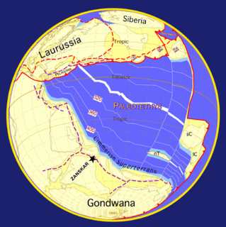
WGondwana or Gondwanaland was a supercontinent that existed from the Neoproterozoic and began to break up during the Jurassic, with the opening of the Drake Passage, separating South America and Antarctica occurring during the Eocene. Gondwana was not considered a supercontinent by the earliest definition, since the landmasses of Baltica, Laurentia, and Siberia were separated from it.
 W
WImphal Valley is located in the Indian state of Manipur and is an irregular almost oval shaped canyon that was formed as a result of the multiple small rivers that originate from neighbouring hill regions surrounding the valley and flow through it. The water in the Imphal valley is fetched from several rivers that flows via the valley, such as Imphal River, Iril River, Thoubal River, Khuga River and Sekmai river.
 W
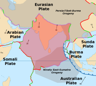
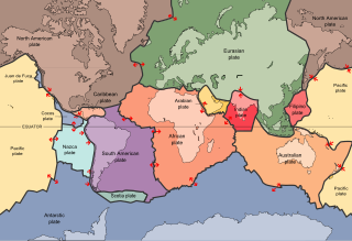
WThe Indian Plate or India Plate is a minor tectonic plate straddling the Equator in the Eastern Hemisphere. Originally a part of the ancient continent of Gondwana, India broke away from the other fragments of Gondwana 100 million years ago and began moving north. Once fused with the adjacent Australia to form a single Indo-Australian Plate, recent studies suggest that India and Australia have been separate plates for at least 3 million years and likely longer. The Indian Plate includes most of South Asia—i.e. the Indian subcontinent—and a portion of the basin under the Indian Ocean, including parts of South China and western Indonesia, and extending up to but not including Ladakh, Kohistan and Balochistan.
 W
WThe Indian subcontinent, or, sometimes simply called the subcontinent, is a physiographical region in southern Asia, situated on the Indian Plate and projecting southwards into the Indian Ocean from the Himalayas. Geologically, the Indian subcontinent is related to the landmass that rifted from the supercontinent Gondwana during the Cretaceous and merged with the Eurasian landmass nearly 55 million years ago. Geographically, it is the peninsular region in south-central Asia, delineated by the Himalayas in the north, the Hindu Kush in the west, and the Arakanese in the east. Geopolitically, the Indian subcontinent generally includes all or part of Bangladesh, Bhutan, India, Nepal, Pakistan and Sri Lanka, as well as Maldives. The terms "Indian subcontinent" and "South Asia" are sometimes used interchangeably to denote the region.
 W
WThe Karakoram fault is an oblique-slip fault system in the Himalayan region across India and Asia. The slip along the fault accommodates radial expansion of the Himalayan arc, northward indentation of the Pamir Mountains, and eastward lateral extrusion of the Tibetan plateau. Current plate motions suggest that the convergence between the Indian Plate and the Eurasian Plate is around 44±5 mm per year in the western Himalaya-Pamir region and approximately 50±2 mm per year in the eastern Himalayan region.
 W
WKhondalite is a foliated metamorphic rock. In India, it is also called Bezwada Gneiss and Kailasa Gneiss. It was named after the Khond tribe of Odisha and Andhra Pradesh because well-formed examples of the rock were found in the inhabited hills of these regions of eastern India.
 W
WThe Main Frontal Thrust (MFT), also known as the Himalayan Frontal Thrust (HFT) is a geological fault in the Himalayas
 W
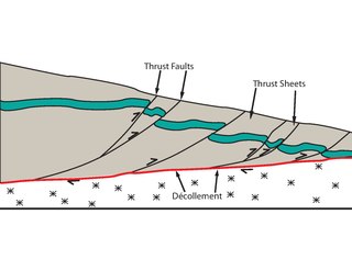
WThe Main Himalayan Thrust (MHT) is a décollement under the Himalaya Range. This thrust fault follows a NW-SE strike, reminiscent of an arc, and gently dip towards the north, beneath the region. It is the largest active continental megathrust fault in the world.
 W
WThere are six soil deposits in India. They are Alluvial soil, Black soil or regur, Red soil, Laterite soil, Desert or Arid soil, and Forest and mountainous soil. These soils are formed by the sediments brought down by the rivers. They are also rich in chemical ingredients.
 W
WThe Masai Plateau, also known as the Masai Pathar or Masai Sadas, is a plateau situated 30 kilometers west from Kolhapur city in Maharashtra.
 W
WThe paleogeography of the India–Asia collision system is the reconstructed geological and geomorphological evolution within the collision zone of the Himalayan orogenic belt. The continental collision between the Indian and Eurasian plate is one of the world's most renowned and most studied convergent systems. However, many mechanisms remain controversial. Some of the highly debated issues include the onset timing of continental collision, the time at which the Tibetan plateau reached its present elevation and how tectonic processes interacted with other geological mechanisms. These mechanisms are crucial for the understanding of Mesozoic and Cenezoic tectonic evolution, paleoclimate and paleontology, such as the interaction between the Himalayas orogenic growth and the Asian monsoon system, as well as the dispersal and speciation of fauna. Various hypotheses have been put forward to explain how the paleogeography of the collision system could have developed. Important ideas include the synchronous collision hypothesis, the Lhasa-plano hypothesis and the southward draining of major river systems.
 W
WThe Panjal Traps or the Tethyan Plume is a large igneous province (LIP) that erupted during the Early–Middle Permian in what is now north-western India. The Panjal Traps are associated with the opening of the Neo-Tethys Ocean, which resulted in the dispersal of the Cimmerian continental blocks from the north-eastern margin of Gondwana and possibly the break-up of this old and large continent. In the Zanskar-Spliti-Lahaul area the 30–150 m (98–492 ft)-thick basalts of the Panjal Traps are mostly exposed as massive (terrestrial) lava flows, but also as (marine) pillow lavas and hyaloclastites.
 W
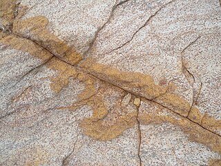
WPeninsular Gneiss is a term coined to highlight the older gneissic complex of the metamorphics found all over the Indian Peninsula. This term was first fashioned by W.F.Smeeth of the Mysore Geological Department in 1916 based on the first scientific study of this rock exposure. The Geological Survey of India identified one of the best exposures of this rock mass, protruding high above the ground as a hillock (pictured), dated 2.5 to 3.4 billion years, in the Bengaluru city in India at the famous Lalbagh gardens and declared it as a National Geological Monument to propagate the knowledge of the rock formation among the public, since Lalbagh is frequented by visitors from all over the world. It is also called the Lalbagh rock.
 W
WThe Indo-Australian Plate is a major tectonic plate that includes the continent of Australia and surrounding ocean, and extends northwest to include the Indian subcontinent and adjacent waters. It was formed by the fusion of Indian and Australian plates approximately 43 million years ago. The fusion happened when the mid-ocean ridge in the Indian Ocean, which separated the two plates, ceased spreading.
 W
WPorbandar stone is the name given to the miliolite limestone found in the carbonate rocks of Saurashtra region in Gujarat, India. During the British Raj, the stone was extensively used in many public buildings of Bombay, including the Victoria Terminus, Knesset Eliyahoo synagogue, Bombay High Court and Crawford Market.
 W
WPre-collisional Himalaya is a term describing the arrangement of the Himalayan rock units before the mountain-building process resulted from the collision between the continents of Asia and India. The collision began in the Cenozoic and it is a type locality of a continental-continental collision. The reconstruction of the initial configuration of the rock units and the relationship between them is highly controversial, and major concerns relate to the arrangements of the different rock units in three dimensions. Several models have been advanced to explain the possible arrangements and petrogenesis of the rock units.
 W
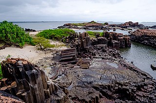
WSt. Mary's Islands, also known as Coconut Island and Thonsepar, are a set of four small islands in the Arabian Sea off the coast of Malpe in Udupi, Karnataka, India. They are known for their distinctive geological formation of columnar rhyolitic lava (pictured).
 W
WIndia possesses a wide spectrum of dimensional stones that include granite, marble, sandstone, limestone, slate, and quartzite, in various parts of the country.
 W
WThe Aravalli Mountain Range is a northeast-southwest trending orogenic belt in the northwest part of India and is part of the Indian Shield that was formed from a series of cratonic collisions. The Aravalli Mountains consist of the Aravalli and Delhi fold belts, and are collectively known as the Aravalli-Delhi orogenic belt. The whole mountain range is about 700 km long. Unlike the much younger Himalayan section nearby, the Aravalli Mountains are much older that can be traced back to the Proterozoic Eon. The collision between the Bundelkhand craton and the Marwar craton is believed to be the primary mechanism for the development of the mountain range.
 W
WTeri or Teri dune complex is a coastal landscape peculiar to some parts of Tamil Nadu mainly in southeastern India. The landscape consists of sediments dating to the Quaternary Period and made of marine deposits with aeolianite and characteristic red sand and silt dunes. These red soils are thought to have originated in the Pleistocene. Robert Bruce Foote hypothesized that these dunes were created by the action of winds (aeolian) lifing the fine silt fraction from further east. These dunes are oriented along the axis running parallel to the coast and between the latitudes of 8°00′ to 9°30′ N and longitudes 77°18′ to 79°00′ E. The soils also have calcium deposits replacing the old roots of vegetation. The soil is rich in ilmenite and the red colour is derived from haematite originating from garnet.