 W
WThe federative units of Brazil are subnational entities with a certain degree of autonomy and endowed with their own government and constitution, which together form the Federative Republic of Brazil. There are 26 states and one federal district. The states are generally based on historical, conventional borders which have developed over time. The states are divided into municipalities, while the Federal District assumes the competences of both a state and a municipality.
 W
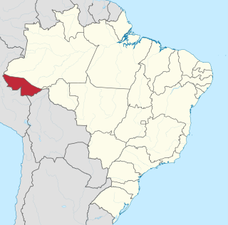
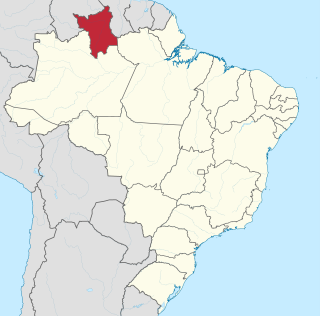
WAcre is a state located in the west of the North Region of Brazil and the Amazonia Legal. Located in the westernmost part of the country, at a two-hour time difference from Brasília, Acre is bordered clockwise by the Brazilian states of Amazonas and Rondônia to the north and northeast, the Bolivian department of Pando to the southeast, and the Peruvian regions of Madre de Dios, Ucayali and Loreto to the south and west.
 W
WAlagoas is one of the 27 states of Brazil and is situated in the eastern part of the Northeast Region. It borders: Pernambuco ; Sergipe (S); Bahia (SW); and the Atlantic Ocean (E). Its capital is the city of Maceió. It has 1.6% of the Brazilian population and produces only 0.1% of the Brazilian GDP. It is made up of 102 municipalities and its most populous cities are Maceió, Arapiraca, Palmeira dos Índios, Rio Largo, Penedo, União dos Palmares, São Miguel dos Campos, Santana do Ipanema, Delmiro Gouveia, Coruripe, Marechal Deodoro, and Campo Alegre.
 W
WAmapá is a state located in the northern region of Brazil. It is the second least populous state and the eighteenth largest by area. Located in the far northern part of the country, Amapá is bordered clockwise by French Guiana to the north, the Atlantic Ocean to the east, Pará to the south and west, and Suriname to the northwest. The capital and largest city is Macapá. The state has 0.4% of the Brazilian population and is responsible for only 0.22% of the Brazilian GDP.
 W
WAmazonas is a state of Brazil, located in the North Region in the northwestern corner of the country. It is the largest Brazilian state by area and the 9th largest country subdivision in the world, and is greater than the areas of Uruguay, Paraguay, and Chile combined. Mostly located in the Southern Hemisphere, it is the third largest country subdivision in the Southern Hemisphere after the Australian states of Western Australia and Queensland. It would be the sixteenth largest country in land area, slightly larger than Mongolia. Neighbouring states are Roraima, Pará, Mato Grosso, Rondônia, and Acre. It also borders the nations of Peru, Colombia and Venezuela. This includes the Departments of Amazonas, Vaupés and Guainía in Colombia, as well as the Amazonas state in Venezuela, and the Loreto Region in Peru.
 W
WBahia is one of the 26 states of Brazil and is in the northeastern part of the country on the Atlantic coast. It is the 4th-largest Brazilian state by population and the 5th-largest by area. Bahia's capital is the city of Salvador, located on a spit of land separating the Bay of All Saints from the Atlantic. Once a monarchial stronghold dominated by agricultural, slaving, and ranching interests, Bahia is now still a predominantly working class industrial and agricultural state.
 W
WCeará, is one of the 27 states of Brazil, located in the northeastern part of the country, on the Atlantic coast. It is the eighth-largest Brazilian State by population and the 17th by area. It is also one of the main tourist destinations in Brazil. The state capital is the city of Fortaleza, the country's fourth most populous city. The state has 4,3% of the Brazilian population and produces only 2,1% of the Brazilian GDP.
 W
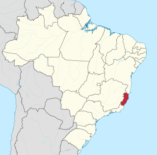
WEspírito Santo is a state in southeastern Brazil. Its capital is Vitória, and its largest city is Serra. With an extensive coastline, the state hosts some of the country's main ports, and its beaches are significant tourist attractions.
 W
WThe Federal District is one of 27 federative units of Brazil. Located in the Center-West Region, it is the smallest Brazilian federal unit and the only one that has no municipalities, being divided into 31 administrative regions. The federal capital of Brazil, Brasília, which is also the seat of government of the Federal District, is located in its territory.
 W
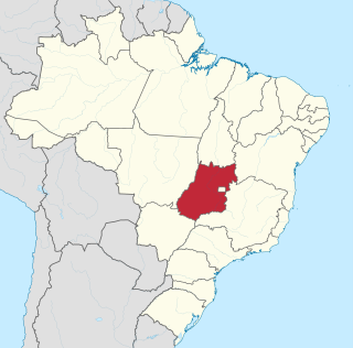
WGoiás is a state of Brazil, located in the Center-West region of the country. The name Goiás comes from the name of an indigenous community. The original word seems to have been guaiá, a compound of gua e iá, meaning "the same person" or "people of the same origin." It borders the Federal District and the states of Tocantins, Bahia, Minas Gerais, Mato Grosso do Sul and Mato Grosso. The state has 3,3% of the Brazilian population and is responsible for 2,7% of the Brazilian GDP.
 W
WMaranhão is a state in Brazil. Located in the country's Northeast Region, it has a population of about 7 million and an area of 332,000 km2 (128,000 sq mi). Going clockwise from the north, it borders on the Atlantic Ocean and the states of Piauí, Tocantins and Pará. The people of Maranhão have a distinctive accent inside the common Northeastern Brazilian dialect. Maranhão is described in books such as The Land of the Palm Trees by Gonçalves Dias and Casa de Pensão by Aluísio Azevedo. The state has 3.4% of the Brazilian population and produces only 1.3% of the Brazilian GDP.
 W
WMato Grosso is one of the states of Brazil, the third largest by area, located in the western part of the country. The state has 1.66% of the Brazilian population and is responsible for 1.9% of the Brazilian GDP.
 W
WMato Grosso do Sul is one of the Midwestern states of Brazil. Neighboring Brazilian states are Mato Grosso, Goiás, Minas Gerais, São Paulo and Paraná. It also borders the countries of Paraguay, to the southwest, and Bolivia, to the west. The economy of the state is largely based on agriculture and cattle-raising. Crossed in the south by the Tropic of Capricorn, Mato Grosso do Sul generally has a warm, sometimes hot, and humid climate, and is crossed by numerous tributaries of the Paraná River. The state has 1,3% of the Brazilian population and is responsible for 1,5% of the Brazilian GDP.
 W
WMinas Gerais is a state in Southeastern Brazil. It ranks as the second most populous, the third by gross domestic product (GDP), and the fourth largest by area in the country. The state's capital and largest city, Belo Horizonte, is a major urban and finance center in Latin America, and the sixth largest municipality in Brazil, after the cities of São Paulo, Rio de Janeiro, Salvador, Brasília and Fortaleza, but its metropolitan area is the third largest in Brazil with just over 5,800,000 inhabitants, after those of São Paulo and Rio de Janeiro. Nine Brazilian presidents were born in Minas Gerais, the most of any state. The state has 10.1% of the Brazilian population and is responsible for 8.7% of the Brazilian GDP.
 W
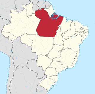
WPará is a State of Brazil, located in northern Brazil and traversed by the lower Amazon River. It borders the Brazilian states of Amapá, Maranhão, Tocantins, Mato Grosso, Amazonas and Roraima. To the northwest are the borders of Guyana and Suriname, to the northeast of Pará is the Atlantic Ocean. The capital and largest city is Belém, which is located at the mouth of the Amazon. The state, which is home to 4.1% of the Brazilian population, is responsible for just 2.2% of the Brazilian GDP.
 W
WParaíba is a state of Brazil. It is located in the Brazilian Northeast, and it is bordered by Rio Grande do Norte to the north, Ceará to the west, Pernambuco to the south and the Atlantic Ocean to the east. Paraíba is the third most densely populated state of the Northeast; João Pessoa, the sea-bordered state capital, and Campina Grande, in the interior, rank among the fifteen-largest municipalities in the Northeast of Brazil. The state is home to 1.9% of the Brazilian population and produces 0.9% of the Brazilian GDP.
 W
WParaná is one of the 26 states of Brazil, in the south of the country, bordered on the north by São Paulo state, on the east by the Atlantic Ocean, on the south by Santa Catarina state and the province of Misiones, Argentina, and on the west by Mato Grosso do Sul and Paraguay, with the Paraná River as its western boundary line. It is subdivided into 399 municipalities, and its capital is the city of Curitiba. Other major cities are Londrina, Maringá, Ponta Grossa, Cascavel, São José dos Pinhais and Foz do Iguaçu. The state is home to 5,4% of the Brazilian population and has 6,2% of the Brazilian GDP. Ignoring Rio de Janeiro oil and mining in Minas Gerais, it's the 2nd strongest state economically in the country.
 W
WPernambuco is a state of Brazil, located in the Northeast region of the country. The state of Pernambuco also includes the archipelago Fernando de Noronha. With an estimated population of 9.2 million people in 2013, it is the seventh-most populous state of Brazil, and is the sixth-most densely populated and the 19th-most extensive among the states and territories of the country. Its capital and largest city, Recife, is one of the most important economic and urban hubs in the country. As of estimates in 2013, Recife's metropolitan area was at that time the fifth-most populous in the country, and the largest urban agglomeration in northeastern Brazil. The state, which has 4,6% of the Brazilian population, produces only 2,8% of the Brazilian GDP.
 W
WPiaui is one of the states of Brazil, located in the country's Northeast Region. The state has 1.6% of the Brazilian population and produces 0.7% of the Brazilian GDP.
 W
WRio de Janeiro is one of the 27 federative units of Brazil. It has the second largest economy of Brazil, with the largest being that of the state of São Paulo. The state, which has 8.2% of the Brazilian population, is responsible for 9.2% of the Brazilian GDP.
 W
WRio Grande do Norte is one of the states of Brazil, located in the northeastern region of the country, occupying the northeasternmost tip of the South American continent. Because of its geographic position, Rio Grande do Norte has a strategic importance. The capital and largest city is Natal. It is the land of the folklorist Luís da Câmara Cascudo. Its 410 km (254 mi) of sand, much sun, coconut palms and lagoons are responsible for the fame of beaches. Rocas Atoll, the only such feature in the Atlantic Ocean, is part of the state. The main economic activity is tourism, followed by the extraction of petroleum, agriculture, fruit growing and extraction of minerals, including considerable production of seasalt, among other economic activities. The state is famous for having many popular attractions such as the Cashew of Pirangi, the dunes and the dromedaries of Genipabu, the famous beaches of Ponta Negra, Maracajaú and Pipa's paradise, the Carnatal the largest off-season carnival in Brazil, the Forte dos Reis Magos is a sixteenth-century fortress, the hills and mountains of Martins, the Natal Dunes State Park the second largest urban park in the country, and several other attractions. The state is also closest to the archipelago of Fernando de Noronha. The state has 1,7% of the brazilian population and produces only 1% of the Brazilian GDP.
 W
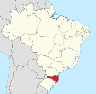
WRio Grande do Sul is a state in the southern region of Brazil. It is the fifth-most-populous state and the ninth largest by area. Located in the southernmost part of the country, Rio Grande do Sul is bordered clockwise by Santa Catarina to the north and northeast, the Atlantic Ocean to the east, the Uruguayan departments of Rocha, Treinta y Tres, Cerro Largo, Rivera and Artigas to the south and southwest, and the Argentine provinces of Corrientes and Misiones to the west and northwest. The capital and largest city is Porto Alegre. The state has the highest life expectancy in Brazil, and the crime rate is relatively low compared to Brazilian national average. Despite the high standard of living, unemployment is still high in the state, as of 2017. The state has 5,4% of the Brazilian population and it's responsible for 6,6% of the Brazilian GDP.
 W
WRondônia is one of the 26 states of Brazil, located in the northern subdivision of the country. To the west is a short border with the state of Acre, to the north is the state of Amazonas, in the east is Mato Grosso, and in the south and southwest is Bolivia. Rondônia has a population of 1,755,000 as of 2014. It is the fifth least populated state. Its capital and largest city is Porto Velho. The state was named after Cândido Rondon, who explored the north of the country during the 1910s. The state, which is home to 0,8% of the Brazilian population, is responsible for 0,6% of the Brazilian GDP.
 W
WRoraima is the northernmost and least populated state of Brazil, located in the Amazon region. It borders the states of Amazonas and Pará and the countries of Venezuela and Guyana. The population is approximately 450,000, and the capital is Boa Vista. Roraima has fifteen municipalities, the fewest of any Brazilian state. The state has 0.3% of the Brazilian population and is responsible for just 0.17% of the Brazilian GDP.
 W
WSanta Catarina is a state in the South Region of Brazil. It is the 7th smallest state in total area and the 11th most populous. Additionally, it is the 9th largest settlement, with 295 municipalities. The state, which has 3.4% of the Brazilian population, is responsible for 3.8% of the Brazilian GDP.
 W
WSão Paulo is one of the 26 states of the Federative Republic of Brazil and is named after Saint Paul of Tarsus. As the richest Brazilian state and a major industrial complex, often dubbed the "locomotive of Brazil", the state, which has 21.9% of the Brazilian population, is responsible for 33.9% of the Brazilian GDP. São Paulo also has the second-highest Human Development Index (HDI) and GDP per capita, the fourth-lowest infant mortality rate, the third-highest life expectancy, and the third-lowest rate of illiteracy among the federative units of Brazil, being by far, the safest state in the country. The homicide rate is 3.8 per 100 thousand as of 2018, almost 1/4 of the Brazilian rate. São Paulo alone has a bigger economy than Argentina, Uruguay, Paraguay, and Bolivia combined. The economy of São Paulo state is the most developed in Brazil. São Paulo is also the world's twenty-eighth-most populous sub-national entity and the most populous sub-national entity in the Americas.
 W
WSergipe, officially State of Sergipe, is a state of Brazil. Located in the Northeast Region along the Atlantic coast of the country, Sergipe is the smallest state in Brazil by geographical area at 21,910 km2, larger only than the Federal District. Sergipe borders Bahia to the south and west and Alagoas to the north. Aracaju is the capital and the largest city in the state. The state has 1,1% of the Brazilian population and produces only 0,6% of the Brazilian GDP.
 W
WTocantins is one of the states of Brazil.. It is the newest of the 26 Brazilian states, formed in 1988 and encompassing what had formerly been the northern two-fifths of the state of Goiás. Tocantins covers 277,620.91 square kilometres (107,190.03 sq mi) and has a population of 1,496,880. Construction of its capital, Palmas, began in 1989; most of the other cities in the state date to the Portuguese colonial period. With the exception of Araguaína there are few other cities with a significant population in the state. The government has invested in a new capital, a major hydropower dam, railroads and related infrastructure to develop this primarily agricultural area. The state has 0,75% of the Brazilian population and it's responsible for 0,5% of the Brazilian GDP.