 W
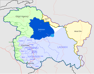
WBaltistan, also known as Baltiyul or Little Tibet, is a mountainous region in Gilgit-Baltistan, Pakistan-administered Kashmir. It is located near the Karakoram mountains just south of K2, and borders Gilgit to the west, China's Xinjiang to the north, Ladakh to the southeast, and the Kashmir Valley to the southwest. Its average altitude is over 3,350 metres (10,990 ft).
 W
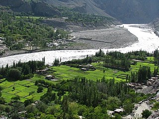
WBalghar is a village in Ghanche, Gilgit Baltistan, Pakistan گانگچھے،گلگت بلتستان، پاکستان on the banks of the Shyok River. The Shyok River meets the Indus River at Keris کریس, about 30 kilometers west of Balghar. Balghar includes 15 large and small neighbourhoods (mahallahs): Gond Balghar, Chan Gond Balghar, Chopya, Rotaka, Ongbo, Marmoung Balghar, Loda Balghar, Khanka Grwong Balghar, Khodakha Balghar, Gareippa Balghar, Krawathang Balghar, Khashu Balghar, Gamba Bordas Balghar, Yompowa Balghar, and Xooq Balghar. House Valley is to the east, Karis Valley to the west, Shiger Valley to the north, and Daghoni/Balghar are located to the south.
 W
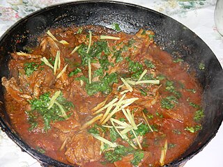
WA balti or bāltī gosht is a type of lamb meat or goat meat curry served in a thin, pressed-steel wok called a "balti bowl". The name may have come from the metal dish in which the curry is cooked, rather than from any specific ingredient or cooking technique. Balti curries are cooked quickly using vegetable oil rather than ghee, over high heat in the manner of a stir-fry, and any meat is used off the bone. This combination differs sharply from a traditional one-pot Indian curry which is simmered slowly all day. Balti sauce is based on garlic and onions, with turmeric and garam masala, among other spices.
 W
WBalti is a Tibetic language spoken by the Balti people in the Baltistan region of Gilgit-Baltistan, Pakistan, the Nubra Valley of Leh district and in the Kargil district of Ladakh, India. It is quite different from Standard Tibetan. Many sounds of Old Tibetan that were lost in Standard Tibetan are retained in the Balti language. It also has a simple pitch accent system only in multi-syllabic words while Standard Tibetan has a complex and distinct pitch system that includes tone contour.
 W
WBaltistan Wildlife Sanctuary is a wildlife sanctuary covering an area of 415 square kilometres in the Baltistan region of northern Pakistan. Contiguous with the Astore Wildlife Sanctuary to its south and east, the Baltistan Wildlife Sanctuary lies south of the Indus River, between the villages of Rondu and Shengus, in the Skardu District. This protected area was established in 1975, for the purpose of conserving the threatened species that occupy the park, and among them there are snow leopard, brown bear, lynx, Tibetan wolf, Tibetan sand fox, markhor, bharal, and Siberian ibex.
 W
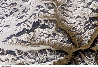
WThe Baltoro Glacier, at 63 km (39 mi) in length, is one of the longest glaciers outside the polar regions. It is located in the Gilgit-Baltistan region of Pakistan. It runs through part of the Karakoram mountain range. The Baltoro Muztagh lies to the south and east of the glacier, while the Masherbrum Mountains lie to the south. At 8,611 m (28,251 ft), K2 is the highest mountain in the region, and three other Eight thousanders within 20 km. Siachen Glacier is separated from the Baltoro glacier by the Conway Saddle.
 W
WThe Barah Valley is a village in Gilgit Baltistan. Barah Valley is 100 km from Skardu in the east. The valley is located on the bank of Shyok river in the Khaplu, of Baltistan.
 W
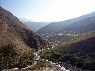
WChorbat Valley is a section of the Shyok river valley divided between Pakistan-administered and Indian-administered Kashmir. The Pakistan-administered portion is in the Khaplu tehsil, Ghanche District of Gilgit–Baltistan and the Indian-administered portion is in the Nubra tehsil, Leh district of Ladakh. Chorbat stretches from the abandoned village of Khaplu to the Bogdang village of Nubra.
 W
WConcordia is the name for the confluence of the mighty Baltoro Glacier and the Godwin-Austen Glacier in the heart of the Karakoram mountain range of Pakistan. It is located in the Baltistan region of Pakistan, at 4,691 metres (15,390 ft) above sea level. The area is often used as a base camp for mountaineering expeditions on K2 and other nearby peaks, and is also a popular destination for trekkers and backpackers.
 W
WGhawari is a small agricultural town and oasis in Ghanche District, Baltistan, Pakistan. It lies on the Shyok River about 14 miles (23 km) east of Sermik and 45.5 miles (73.2 km) southeast of Skardu. There is a suspension bridge over the Shyok in the southeast of the town which leads to Kuroo on the other side of the river. It is well known as a center of Islamic scholarship and learning and for its production of cherries and associated festival.
 W
WHaldi Cones are a group of mountains located in Karakoram range in Ghanche district of Gilgit Baltistan. The granite peaks are located in Haldi village located at a distance of 25 km from Khaplu town. Most of these towers and cones are not climbed yet. While the peaks of Khane Valley located in the north of Haldi cones were climbed.
WHaldi also Halde or Huldi is a village in Ghanche District of Gilgit-Baltistan, Pakistan. Haldi is historic village of Baltistan, which is located at the meeting place of Saltoro river and Hushe River 28 km from district centre Khaplu.
 W
WHassanabad is a village in Sub-Division Chorbat, Ghangche District of Gilgit-Baltistan, Pakistan, lying 141 kilometres (88 mi) east of Skardu, near the border of India.
 W
WThe Keris Valley is a village of Ghanche District Beside the Shyok River lying 39.3 km from Skardu in the east. The valley is at the confluence of the Indus River, and the Shingo River which passes through Kharmang after originating in the Kargil region across the Line of Control.
 W
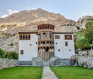
WKhaplu, also spelt Khapalu, is a town that serves as the administrative capital of the Ghanche District of Gilgit-Baltistan, in northern Pakistan. Lying 103 km (64 mi) east of the town of Skardu, it was the second-largest kingdom in old Baltistan of the Yabgo dynasty. It guarded the trade route to Ladakh along the Shyok River east of its confluence with the Indus.
 W
WThe Kharmang Valley is one of five main valleys in the Gilgit Baltistan region of Pakistan. The area became a district in 2015, with temporary headquarters at Tolti. The valley sits about 120 kilometres (75 mi) from Skardu.
 W
WThe Panmah Muztagh is a subrange of the Karakoram range, in Shigar, a district of Gilgit-Baltistan, Pakistan. Its highest peaks are not particularly high by Karakoram standards, but they are exceedingly steep rock spires, unlike many of the peaks in the surrounding subranges. In particular, the highest of the Panmah peaks, Baintha Brakk, is a very difficult climb; it has seen only two ascents. The nearby Latok group is of similar difficulty. Both groups lie on the north side of the long Biafo Glacier.
 W
WRoundu District is a district of the Pakistan-administered mountainous region of Gilgit-Baltistan. The district encompasses the entire Roundu Valley, which is the fourth-largest valley of Baltistan after Skardu, Khaplu, and Shigar in Gilgit-Baltistan. The valley is situated in the west of Baltistan, and forms the main trade and travel route between Baltistan and Gilgit. Roundu was carved out from Skardu District in 2019.
 W
WThe Saltoro Mountains are a subrange of the Karakoram Range. They are located in the southeast Karakoram on the southwest side of the Siachen Glacier, one of the two longest glaciers outside the polar regions. The name given to this range is shared with the Saltoro Valley which is located to the west of this range, downslope on the Pakistan side of the Saltoro Range which generally follows the Actual Ground Position Line. Saltoro Kangri peak, Saltoro River, and Saltoro Valley are features on this range. Actual Ground Position Line (AGPL) between India held and Pakistan held area runs through this range where higher peaks and passes of disputed Siachen area are held by India and Pakistan occupies the lower peaks and valleys.
 W
WSheosar Lake is a lake situated in Deosai National Park, in Gilgit-Baltistan province of northern Pakistan. It is located at the height of 4,142 metres (13,589 ft).
 W
WShigar is the headquarter of its namesake district and tehsil in the Baltistan division of Gilgit–Baltistan in northern Pakistan. It is located at the bank of Shigar River in the most remote and dramatic part of the region. It is a popular site for tourists and trekkers and contains many historical buildings of architectural significance associated with several different communities.
 W
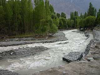
WShigar River is located in the mountainous Baltistan region of northern Pakistan. The Shigar River is formed from the melted water of the Baltoro Glacier and Biafo Glacier. It flows through the Shigar Valley. The river is tributary to Indus River and meets the Indus in Skardu Valley.
 W
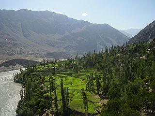
WThe Shigar Valley is a valley in Gilgit Baltistan in northern Pakistan that is watered by the Shigar River, and centred on the town of Shigar. The valley stretches about 170 km from Skardu to Askole and is the gateway to the high mountains of the Karakoram. The town of Shigar is the largest settlement in valley. Even though the Shigar Valley is a remote and largely inaccessible place, there are several villages in the valley. Askole is the last settlement in the Shigar Valley, which is still far from the high mountains. Shigar was an administrative sub-division of Skardu District that is now a district in its own right.
 W
WSiksa is a village in the Chorbat Valley, Ghanche District of Gilgit-Baltistan, Pakistan, lying 150 kilometres (93 mi) east of Skardu, near the border of Pakistan and India at an elevation of 2,725 metres (8,940 ft).
 W
WSkardu is a city in Gilgit-Baltistan region of Pakistan, and serves as the capital of Skardu District. Skardu is located in the 6 kilometres wide by 23 kilometres long Skardu Valley, at the confluence of the Indus and Shigar Rivers at an elevation of nearly 2,500 metres. The city is an important gateway to the eight-thousanders of the nearby Karakoram Mountain range. The town is located on the Indus river, which separates the Karakoram Range from the Himalayas.
 W
WSurmo Valley is a valley in Ghangche District, in Gilgit–Baltistan, Pakistan. Etymologically, the name is derived from sermo : ser meaning gold and mo is a suffix used to feminise the word.
WThagas is a village in Gilgit Baltistan, Pakistan located 32 km away from Khaplu in east. It is on the bank of the Saltoro River just before it joins the Shyok River. Thagas is the administrative headquarters of Mashabrum subdivision of Ghanche District.
 W
WTolti is a city that serves as the administrative capital of Kharmang District, Gilgit Baltistan, Pakistan. It means "Little Tibet". The village lies on the left bank of the Indus, and is approximately 35 km south-east of the confluence of the Indus from the Shayok. It is today by a well-paved road that runs along the left bank of the Indus slightly from Skardu to reach out.
 W
WThe Trango Towers are a family of rock towers situated in Gilgit-Baltistan, in the north of Pakistan. The Towers offer some of the largest cliffs and most challenging rock climbing in the world, and every year a number of expeditions from all corners of the globe visit Karakoram to climb the difficult granite. They are located north of Baltoro Glacier, and are part of the Baltoro Muztagh, a sub-range of the Karakoram range. The highest point in the group is the summit of Great Trango Tower at 6,286 m (20,623 ft), the east face of which features the world's greatest nearly vertical drop.