 W
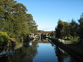
WThe Alexandra Canal, a tributary of the Cooks River, is a heritage-listed artificial waterway in southern Sydney, New South Wales, Australia. Alexandra Canal was named after Princess Alexandra, who married Edward, Prince of Wales in 1863.
 W
WBardwell Creek, an urban watercourse of the Cooks River catchment, is located in the southern suburbs of Sydney, in New South Wales, Australia.
 W
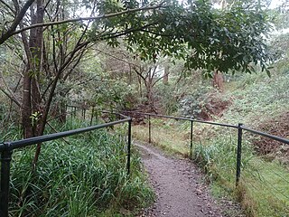
WBare Creek, a watercourse that is part of the Middle Harbour catchment of Sydney Harbour, is located in the northern beaches region of Sydney, New South Wales, Australia.
 W
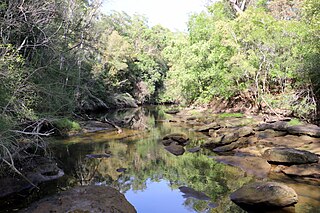
WThe Berowra Creek, a watercourse that is part of the Hawkesbury-Nepean catchment, is located to the north of the Sydney central business district in the Hornsby Shire of New South Wales, Australia.
 W
WBungaroo is a locality near St. Ives, Sydney, Australia. The location is thought to be the site where Governor Arthur Phillip and party camped on the night of 16 April 1788 on the first of many expeditions intended to find arable land that could supply the Colony with agricultural products. The colony at Sydney Cove was dependent on supplies from England, but the soils around the harbour were too poor to support crops and sustain the Colony. This trip is very historic for the Ku-ring-gai Shire, being when Europeans first entered there. It is very historic for the entire Colony or State, being when the Blue Mountains were first sighted. It is believed from later statements made by Governor Phillip that he realized on seeing such large mountains that they must have a large river with rich alluvial soils. Thus the day after camping at Bungaroo the Colony's ultimate survival was realized, and it would be very soon indeed that the Governor would direct endeavour westwards with major consequences. As all that unfolded, unto this day, some consider that Bungaroo is the sole place recognizable in the colonists' writings of 1788 which now remains unchanged from as it was then.
 W
WBusby's Bore, Sydney's second water supply, is a heritage-listed former water management facility located between Centennial Park and College Street, Surry Hills, City of Sydney, New South Wales, Australia. It was designed by John Busby and built from 1827 to 1837 by convict labour. It is also known as Busbys Bore. The property is owned by Sydney Water, an agency of the Government of New South Wales. It was added to the New South Wales State Heritage Register on 2 April 1999, and on local government heritage registers.
 W
WCharity Creek, a northern tributary of the Parramatta River, is a creek west of Sydney Harbour, located in Sydney, New South Wales, Australia. It joins Parramatta River at Meadowbank Park, Meadowbank.
 W
WClear Paddock Creek is a tributary of Orphan School Creek, which in turn, is a tributary of Prospect Creek, located in the City of Fairfield, NSW. It flows north from Bonnyrigg, then turns its course north-east from Edensor Road, before emptying into Orphan School Creek in Wakeley. It is approximately 5 km in length.
 W
WCoal and Candle Creek is a creek located in Sydney, Australia. It is a tributary of Cowan Creek which flows into the Hawkesbury River.
 W
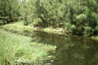
WCowan Creek is located in New South Wales, Australia. It is a tidal subcatchment of the Hawkesbury River. Almost all of the catchment lies within Ku-ring-gai Chase National Park. Tributaries include Coal and Candle Creek, which branches off from Cowan Creek at Cottage Point and Smiths Creek.
 W
WCup and Saucer Creek, an urban watercourse of the Cooks River catchment, is located in the Canterbury-Bankstown region of Sydney, in New South Wales, Australia.
 W
WThe Darling Mills Creek, an urban watercourse that is part of the Parramatta River catchment, is located in Greater Western Sydney, New South Wales, Australia.
 W
WDevlins Creek, an urban watercourse that is part of the Parramatta River catchment, is located in Northern Suburbs region of Sydney, Australia.
 W
WDuck Creek is a perennial stream and a southern tributary of A'Becketts Creek and part of the Parramatta River catchment, in Sydney, New South Wales, Australia.
 W
WHaslams Creek, a southern tributary of the Parramatta River, is a creek west of Sydney Harbour, located in Sydney, Australia. It flows through Sydney Olympic Park and joins Parramatta River at Homebush Bay.
 W
WThe Hawthorne Canal, a southern tributary of the Parramatta River, is a heritage–listed artificial waterway located in the western reaches of Sydney Harbour, in the inner–western Sydney suburbs of Lewisham, Summer Hill, Haberfield, and Leichhardt in New South Wales, Australia.
WHunts Creek, an urban watercourse that is part of the Parramatta River catchment, is located in Greater Western Sydney, New South Wales, Australia.
 W
WIron Cove Creek, a southern tributary of the Parramatta River, is an urban stream west of Sydney Harbour, located in the inner-western Sydney suburbs of Croydon, Ashfield, Haberfield and Five Dock in New South Wales, Australia.
 W
WJohnstons Creek, formerly Johnston's Creek, is an urban gully, located in Sydney, Australia and situated in the Leichhardt local government area. The creek flows from Petersham, past Annandale, Camperdown, Forest Lodge and Harold Park, before spilling into Rozelle Bay, within Sydney Harbour.
 W
WThe Lower Prospect Canal Reserve is a heritage-listed former farm and public water supply canal and now bushy corridor and nature reserve stretching 7.7 kilometres (4.8 mi) through the heart of suburban Sydney, New South Wales, Australia. The lineal corridor stretches from Prospect Reservoir to Sydney Water Pipehead at Albert Street, Guildford with the majority of the reserve located in Greystanes, which is a suburb within the Cumberland Council area.
 W
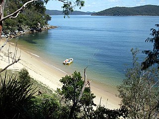
WMiddle Harbour Creek, a tributary of Middle Harbour, is a youthful tide-dominated, drowned-valley estuary north–west of Sydney Harbour, in Sydney, New South Wales, Australia.
 W
WOrphan School Creek is a storm drain located in inner Sydney, New South Wales. It is a tributary of Johnstons Creek which flows into Rozelle Bay.
 W
WProspect Creek, an urban watercourse of the Georges River catchment, is located in the western and Canterbury-Bankstown regions of Sydney, in New South Wales, Australia.
WScout Creek is an urban gully, is located in Hornsby Shire local government area of Sydney, New South Wales, Australia. It is part of the Parramatta River catchment.
 W
WThe South Creek or Wianamatta, a creek that is part of the Hawkesbury-Nepean catchment, is located on the Cumberland Plain, also referred to as Greater Western Sydney, New South Wales, Australia.
 W
WThe Tank Stream is a heritage-listed former fresh water tributary of Sydney Cove and now tunnel and watercourse located in the Sydney central business district, in the City of Sydney local government area of New South Wales, Australia. The Tank Stream was the fresh water supply for the fledgling colony of New South Wales in the late 18th century. Today it is little more than a storm water drain. It originated from a swamp to the west of present-day Hyde Park and at high tide entered Sydney Cove at what is now the intersection of Bridge and Pitt Streets in the Sydney central business district. The catchment was 65 hectares, corresponding roughly the size of the Sydney central business district. It was added to the New South Wales State Heritage Register on 2 April 1999.
 W
WVineyard Creek, a northern tributary of the Parramatta River, is a creek west of Sydney Harbour, located in Sydney, Australia.
 W
WWhites Creek, formerly known as White's Creek, was once a natural waterway that was concreted to improve sanitation. The creek is now a heritage–listed artificial waterway located in the inner–west region of Sydney, New South Wales, Australia.
 W
WWolli Creek is an urban watercourse of the Cooks River catchment located in the southern suburbs of Sydney, in New South Wales, Australia.