 W
WFalam District is a district of the Chin State in Myanmar. It consists of 5 townships and 515 villages. The major towns include: Chikha (Gyikhar), Tonzang (Htonzan), Tiddim, Fort White, Falam and Hakha. They call themselves Mizo.
 W
WHinthada District is a district of Ayeyarwady Division, Myanmar.
WHopang District is a district of Shan State, Burma. It is part of the Wa Self-Administered Division. It was set up in 2011 and consists of three townships, Hopang, Mongmai and Pangwan, and two subtownships, Namtit and Panlong.
 W
WKale District is the westernmost district in Sagaing Division of Myanmar (Burma).
WKengtung District is a district of the Shan State in Myanmar. It consists of 3 towns and 1449 villages.
WKunlong District is a district of the Shan State in Myanmar. It consists of 2 towns and 458 villages. The main road of the District, Hsenwi-Kunlong-Chinshwehaw road, is 66 miles long.
WKyaukme District is a district of northern Shan State in Burma (Myanmar). As of 2001, it consisted of 9 towns and 1946 villages.
WLashio District is a district of Shan State in Myanmar. It consisted of four towns and 2431 villages in 2001.
WLaogai District is a district of the Shan State in Myanmar. It consists 2 towns and 333 villages.
WLoikaw District is a district of the Kayah State in eastern part of Myanmar.
WLoilem District is a district of the Shan State in Myanmar. It consists of 9 towns in 2010. Its capital is Loilem.
 W
WMandalay District is a district of the Mandalay Division in central Myanmar. Though the district used to consist of two cities, Mandalay and Amarapura, today, with the urban sprawl of Mandalay capturing Amarapura and Patheingyi, the district and the city of Mandalay are one and the same.
WMatman District or Metman District is a district of Shan State, Burma. It is part of the Wa Self-Administered Division. It was formerly part of Hopang District. Matman District consists of three townships: Matman, Namphan and Pangsang.
 W
WMaungdaw District is a district of Rakhine State in western Myanmar (Burma). Its capital city is Maungdaw and the population density is about 295 persons per square kilometer, in this district 95% population is the Rohingya Thayinthar also this is one of the districts where most Muslim are living in Myanmar [Burma] .The Rohingya people are being persecuted and also genocide by their government to his own people who has been living there more than 2000 years before, nearly 15% population is Rakhine Thayinthar. Along with parts of neighbouring Sittwe District, Maungdaw District is also informally referred to as northern Rakhine State.
WMawlaik District is a district in central Sagaing Division of Burma (Myanmar). Its administrative center is the town of Mawlaik.
 W
WMawlamyine District is a district of the Mon State in Myanmar. The capital is Mawlamyine town. The district covers an area of 6,084 km², and had a population of 1,232,221 at the 2014 Census.
WMeiktila District is a district of the Mandalay Division in central Burma.
 W
WMohnyin District is a district of the Kachin State in northern Burma (Myanmar). The administrative center is Mohnyin.
WMonywa District is an administrative district in southern Sagaing Division, Burma (Myanmar). Its administrative center is the city of Monywa.
WMu Se District is a district of the Shan State in Burma (Myanmar). As of 2001, it consisted of 4 towns and 1162 villages. The capital is at Muse.
WNaypyitaw Union Territory is an administrative division in central Myanmar (Burma). It contains Naypyidaw, the capital city of Myanmar.
WPakokku District is a district of the Magway Division in central Burma (Myanmar). It is situated in northern part of Magwe Region. The administrative centre is the city of Pakokku.Pakokku is a largest city of Magway Division.It is also the 13th largest city of Burma (Myanmar).The townships of Pakokku District are Pakokku, Yesagyo, Pauk, Seikphyu, Myaing, Htilin, Saw and Gangaw.
 W
WPathein District is a district of Ayeyawady Division, Myanmar. It is located around the city of Pathein and includes the urban area of it. The area of the Pathein District is 10899.8 km². Its population was 1,630,716 in 2014.
WPyin Oo Lwin District is a district of the Mandalay Region in central Burma. It lies northeast of Mandalay, with the Myitnge River as its southern boundary. To the east it is bordered by Shan State and in part by the Chaung Magyi. It goes north as far as the town of Dakaung where it adjoins Htigyaing Township, Katha District in Sagaing Region. Its western boundary, is for the most part the Irrawaddy, but a very small portion of Thabeikkyin Township is west of the Irrawaddy, near the town of Baw in Sagaing Region. To the southwest it borders Mandalay District.
 W
WSagaing District is an administrative district in southern Sagaing Division, Burma (Myanmar). Its administrative center is the city of Sagaing.
 W
WShwebo District is a district in south-central Sagaing Division of Burma (Myanmar). Its administrative center is the city of Shwebo.
WTachileik District is a district of the Shan State in Myanmar. It consists of one town and 295 villages. It is one of the four districts of Eastern Shan State.
WTaunggyi District is a district of Shan State in Burma. The principal town and administrative center is Taunggyi. This district has 12 towns and 3001 villages.
 W
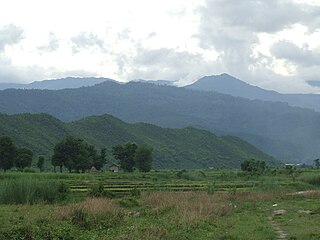
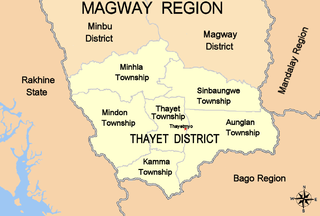
WThayet District is a district of the Magway Division in central Burma (Myanmar). The administrative centre is the town of Thayet.