 W
WBahía de Cádiz Natural Park is a 10,522-hectare (26,000-acre) natural park located in the province of Cádiz. It was established in 1989.
 W
WThe Barbate is a coastal river in southern Spain. It flows into the Atlantic Ocean at Barbate in the province of Cádiz, autonomous community of Andalusia.
 W
WThe Bay of Cádiz is a body of water in the province of Cádiz, Spain, adjacent to the southwestern coast of the Iberian Peninsula.
 W
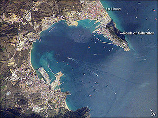
WThe Bay of Gibraltar is a bay at the southern end of the Iberian Peninsula. It is around 10 km (6.2 mi) long by 8 km (5.0 mi) wide, covering an area of some 75 km2 (29 sq mi), with a depth of up to 400 m (1,300 ft) in the centre of the bay. It opens to the south into the Strait of Gibraltar and the Mediterranean Sea.
 W
WCala Arenas is a beach situated near the city of Algeciras in Spain, within the El Estrecho Natural Park. It is located at the southern end of the Bay of Gibraltar and faces the Strait of Gibraltar. It measures about 400 metres (1,300 ft) long by about 30 metres (98 ft) deep. The beach is somewhat difficult to access, but can be reached via coastal paths from Punta Carnero and Punta del Fraile. It consists of a series of three small coves of similar appearance, with beaches of rocks and small stones. Both the terrestrial and marine environment of the area lies within the natural park. Its surroundings are largely undisturbed by human activity; the nearest settlement is the coastal community of Getares, a small outlying development of the city of Algeciras located about 1 km to the north. The beach is framed by cliffs and the Isla de las Palomas lies a short distance offshore.
WCaño de Sancti Petri is a shallow channel in the province of Cádiz, Andalusia, southwestern Spain. Narrow and winding, it is situated between Isla de León from the mainland, and is part of the Bahía de Cádiz Natural Park.
 W
WThe Costa de la Luz is a section of the Andalusian coast in Spain facing the Atlantic. It extends from Tarifa in the south, along the coasts of the Province of Cádiz and the Province of Huelva, to the mouth of the Guadiana River.
 W
WThe Guadalete River is located almost entirely in the Spanish province of Cádiz, rising in the Sierra de Grazalema Natural Park at an elevation of about 1,000 metres (3,300 ft), and running for 172 kilometres (107 mi) into the Bay of Cádiz at El Puerto de Santa Maria, north of the city of Cádiz. The river's name comes from the Arabic phrase meaning "River of Forgetfulness".
 W
WThe Guadarranque is a short coastal river of Spain in the Andalusian comarca of Campo de Gibraltar in the province of Cádiz. It is impounded to form the Embalse de Guadarranque. Its name is derived from the Arab Wadi Ramke or "river of mares" The Guadarrranque, 43 kilometres (27 mi) long, rises in the monte de Castellar, a short distance from the city of Castellar Viejo, and empties into the Bay of Algeciras.
 W
WIsla del Trocadero is an island in the Bay of Cádiz, in Andalusia, Spain.
 W
WThe Islote de Sancti Petri is a small barren island belonging to the municipality of San Fernando, Cádiz in the province of Cádiz and the autonomous region of Andalusia, Spain. It is close to the coast and some 16km south of Cadiz city.
 W
WLa Breña y Marismas del Barbate Natural Park is a natural park on the coast of the province of Cádiz, Spain. The park includes marine and terrestrial ecosystems. An area of the natural park has been planted with pines to control the spread of sand-dunes.
 W
WLos Alcornocales Natural Park is a natural park located in the south of Spain, in the autonomous community of Andalusia; it is shared between the provinces of Cádiz and Málaga. The natural park occupies a territory spanning seventeen municipalities with a total population of about 380,000. "Los Alcornocales" means "the cork oak groves".
 W
WThe Río Palmones is a river of the Province of Cádiz in Southeastern coastal Spain. Its source is in Lomas del Castaño, Sierra Blanquilla, and it flows for some 37 kilometres (23 mi) into the Bay of Gibraltar, North of the city of Algeciras, in the neighborhood of Palmones. The Battle of Río Palmones took place here in 1342.
 W
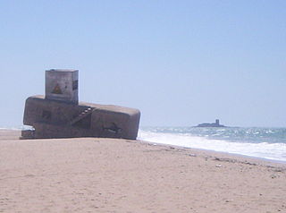
WPlaya de Camposoto is one of the longest beaches in southern Spain, located in the Province of Cadiz. It looks across to the Islote de Sancti Petri and is located to the north of Playa de la Barrosa. It contains Búnker 1 de Camposoto and Búnker 2 de Camposoto, bunkers from the war.
 W
WPlaya de El Chinarral is a beach in the municipality of Algeciras, southeastern Spain. It overlooks the Bay of Algeciras and the tip of the rock of Gibraltar. It is approximately 250 metres in length and 40 metres wide on average. It is located between Punta de San Garcia and El Rodeo, south of the city.
 W
WPlaya de El Rinconcillo is a beach in the Province of Cadiz, Andalusia, Spain, located to the north of the city of Algeciras, near the neighborhood of El Rinconcillo. It looks across to the rock of Gibraltar and La Línea de la Concepción.
 W
WPlaya de Getares is a beach in the municipality of Algeciras, southeastern Spain. It overlooks the Bay of Gibraltar about 5 kilometres (3.1 mi) south of the city of Algeciras, between Punta San García and Punta Carnero, where the cliffs begin on the Strait of Gibraltar. It is approximately 1.5 kilometres (0.93 mi) in length and 40 metres (130 ft) wide on average.
 W
WPlaya de la Barrosa is a 6 kilometres (3.7 mi) long beach in the municipality of Chiclana de la Frontera, Province of Cádiz, Spain. It was the site of the Battle of Barrosa in 1811. it is separated from the Playa de Sancti Petri by a cliff. The resort of Novo Sancti Petri lies at the south end of Playa de la Barrosa and contains a defensive tower structure called Torre Bermeja. Several pieces of music have been composed about the beach including Isaac Albéniz's Torre Bermeja and Paco de Lucía's La Barrosa.
 W
WPlaya de Los Ladrillos is a beach in the municipality of Algeciras, southeastern Spain. It overlooks the Bay of Algeciras, next to Playa del Barranco. It is about 200 metres in length.
 W
WPlaya del Barranco is a beach in the municipality of Algeciras, southeastern Spain. It overlooks the Bay of Algeciras. It is approximately 500 metres in length. To the north is the Playa de El Rinconcillo.
 W
WThe Puerto de las Palomas is a road through two mountains inside the Sierra de Grazalema Natural Park, connecting Grazalema and Zahara de la Sierra villages.
 W
WThe Río de la Miel is a short river in the south of Spain, emptying into the Bay of Gibraltar at Algeciras. It falls over a distance of 350 metres including some waterfalls and working water mills. As the port of Algeciras expanded, docks on the river became marooned inland, and within the town much of the river is now culverted.
 W
WSan Pedro is a small stream in the province of Cádiz, Spain, close to Guadalete river. It runs for 25 km into the Bay of Cádiz. It flows by Bahía de Cádiz Natural Park.
 W
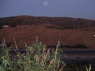
WThe Sierra Carbonera is a small range of mountains located in the Province of Cádiz in Spain, at the boundary between the municipalities of San Roque and La Línea de la Concepción, north of the Rock of Gibraltar. It rises to a maximum altitude of 311 metres (1,020 ft) at the summit of Carboneras, which is occupied by a radio communications installation.
 W
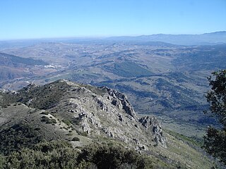
WThe Sierra de Grazalema Natural Park is a natural park in the northeastern part of the province of Cádiz in southern Spain. The park encompasses, within its 51,695 hectares, a complex of mountain ranges, known collectively as the Sierra de Grazalema, which, in turn, are part of the Cordillera Subbética. Other ranges within the park, comprising the Sierra de Grazalema, include the Sierra de Zafalgar, the Sierra del Pinar, and the Sierra de Endrinal. Pinar, 1654 metres in elevation, is the tallest peak.
 W
WCape Trafalgar is a headland in the Province of Cádiz in the south-west of Spain. The 1805 naval Battle of Trafalgar, in which the Royal Navy commanded by Admiral Horatio Nelson decisively defeated Napoleon's combined Spanish and French fleet, took place off the cape.
 W
WThe Vía Verde de la Sierra is a rail trail for tourist use comprising 38 km (24 mi) of mountainous landscape between Puerto Serrano and Olvera villages, provinces of Cádiz and Sevilla. It is part of Vías Verdes of Spain.
 W
WThe White Towns of Andalusia, or Pueblos Blancos, are a series of whitewashed towns and large villages in the northern part of the provinces of Cádiz and Málaga in southern Spain, mostly within the Sierra de Grazalema Natural Park.