 W
WThe 1916 Pensacola hurricane was a tropical cyclone that swept across the western Caribbean Sea and Gulf of Mexico in October 1916. It was the last hurricane of the 1916 Atlantic hurricane season, forming as a tropical depression near Jamaica on October 9 and moved slowly southwest and west, taking an unusual track for storms in October. Intensification was initially slow, but proceeded in earnest after October 11 as the depression strengthened into a tropical storm and then a hurricane. It passed over the Swan Islands before moving ashore the Yucatán Peninsula on October 15 near the border between the British Honduras and Mexico. Plantains and coconuts in the British Honduras sustained harsh losses. Twenty people were killed following the loss of a ship in the western Caribbean. The tropical cyclone weakened as it moved across the peninsula and curved north into the Gulf of Mexico on October 16.
 W
WThe 1931 British Honduras hurricane was the deadliest hurricane in the history of British Honduras, killing an estimated 2,500 people. The hurricane was first detected as a tropical wave off the west coast of Africa on 29 August. Moving westward, the disturbance remained relatively weak until 6 September, when it was first classified as a tropical cyclone just west of the Windward Islands. The depression gradually intensified, reaching tropical storm intensity within the first six hours following tropical cyclogenesis. The cyclone intensified further to hurricane intensity by 8 September. Strengthening and organisation remained gradual until the storm reached the Gulf of Honduras, by which time it began to rapidly intensify, reaching Category 4 hurricane intensity on 10 September. The hurricane subsequently made landfall in Belize City with maximum sustained winds of 135 mph (215 km/h). Moving across the Yucatán Peninsula, the tropical cyclone weakened, and continued to do so when it moved across the Bay of Campeche. This track brought it to a second landfall north of Tampico, Mexico, as a tropical storm on 13 September. Once inland, the storm quickly weakened and dissipated later that day.
 W
WThe 1942 Belize hurricane was the only known hurricane to strike Belize in the month of November. The thirteenth observed tropical cyclone, eleventh tropical storm, and fourth hurricane of the 1942 Atlantic hurricane season, this storm was detected in the vicinity of Turks and Caicos Islands on November 5. Initially a tropical storm, it strengthened slowly while moving westward and then south-southwestward across the Bahamas. On November 6, the storm became a Category 1 hurricane on the modern day Saffir–Simpson hurricane wind scale. Later that day, it made landfall in Cayo Romano, Camagüey Province, Cuba. Impact in Cuba and the Bahamas was limited to lower barometric pressure readings and strong winds. While crossing Cuba, the system weakened to a tropical storm early on November 7, shortly before emerging into the Caribbean Sea. The storm re-strengthened into a hurricane later that day and headed southwestward.
 W
WHurricane Abby was the only tropical cyclone in the Caribbean Sea during the 1960 Atlantic hurricane season. The second tropical cyclone and first named storm of the season, Abby developed on July 10 from a tropical wave in the vicinity of the Lesser Antilles. Abby rapidly intensified into a hurricane after being a tropical storm for less than six hours. It briefly peaked as a category 2 hurricane before weakening back. Abby rapidly weakened to a minimal tropical storm a few days thereafter. The storm re-strengthened into a hurricane as it began to parallel the coast of Honduras. Hurricane Abby made landfall in British Honduras on July 15. Abby dissipated over Mexico later the next day. The remnants of Abby ultimately became Hurricane Celeste in the Pacific Ocean. Despite passing through or near several countries, Hurricane Abby had a relatively light impact on land, resulting in just $640,500 in damage and six fatalities.
 W
WTropical Storm Barry was a weak and short-lived tropical cyclone that brought heavy rains to parts of Central America and Mexico in June 2013. Barry originated from a tropical wave that developed in the southern Caribbean Sea. The wave tracked northwestward and began to develop in marginally favorable conditions. On June 17, the disturbance was upgraded to Tropical Depression Two by the National Hurricane Center. Due to its close proximity to land, the system failed to intensify before crossing the southern Yucatán Peninsula. The depression emerged over the Bay of Campeche late on June 18 and became increasingly organized. During the afternoon of June 19, data from Hurricane Hunters revealed the system had intensified into a tropical storm. The newly named Barry attained peak winds of 45 mph (75 km/h) before making landfall in Veracruz, Mexico on June 20. Once onshore, the storm quickly weakened and degenerated into a remnant low that night.
 W
WThe 1934 Central America hurricane was a tropical cyclone that caused at least 506 fatalities in Central America in June 1934, making it one of the deadliest hurricanes in Atlantic history. Its peak strength in the Gulf of Mexico was equivalent to a Category 2 hurricane on the modern Saffir–Simpson scale. The storm's path was erratic, beginning in the Gulf of Honduras on June 4 shortly before making its first landfall on the British Honduras as a tropical storm. It then took a looping course through Guatemala before reemerging into the Gulf of Honduras on June 8. The storm struck the northeastern Yucatán Peninsula as a hurricane on June 9, crossing into the western Gulf of Mexico where its course made another loop. An accelerated northward course followed, leading to the hurricane's landfall along the Louisiana coast on June 16. It weakened over land and transitioned into an extratropical cyclone on June 18, accelerating northeast towards the Canadian Maritimes thereafter.
 W
WTropical Storm Chantal was a North Atlantic tropical cyclone that moved across the Caribbean Sea in August 2001. The fourth depression and third named storm of the 2001 Atlantic hurricane season, Chantal developed from a tropical wave on August 14 in the tropical Atlantic Ocean. It tracked rapidly westward for much of its duration, and after degenerating into a tropical wave, it passed through the Windward Islands. Chantal reached a peak intensity of 70 mph (110 km/h) twice in the Caribbean Sea, and each time it was anticipated to attain hurricane status; however, wind shear and later land interaction prevented strengthening to hurricane status. On August 21 Chantal, moved ashore near the border of Mexico and Belize, before dissipating on the next day.
 W
WHurricane Dean was the strongest tropical cyclone of the 2007 Atlantic hurricane season. It was the most intense North Atlantic hurricane since Hurricane Wilma of 2005, tying for eighth overall. Additionally, it made the fourth most intense Atlantic hurricane landfall. A Cape Verde hurricane that formed on August 13, 2007, Dean took a west-northwest path from the eastern Atlantic Ocean through the Saint Lucia Channel and into the Caribbean. It strengthened into a major hurricane, reaching Category 5 status on the Saffir–Simpson hurricane wind scale before passing just south of Jamaica on August 20. The storm made landfall on the Yucatán Peninsula on August 21 at peak intensity. It crossed the peninsula and emerged into the Bay of Campeche weakened, but still remained a hurricane. It strengthened briefly before making a second landfall near Tecolutla in the Mexican state of Veracruz on August 22. Dean drifted to the northwest, weakening into a remnant low which dissipated uneventfully over the southwestern United States. Dean was the second-most intense tropical cyclone worldwide of 2007 in terms of pressure, only behind Cyclone George in the Australian region, and tied with Felix as the most intense worldwide in terms of 1-minute sustained winds.
 W
WHurricane Earl was the deadliest Atlantic hurricane to impact Mexico since Hurricane Stan in 2005. The fifth named storm and second hurricane of the 2016 Atlantic hurricane season, Earl formed from a tropical wave south of Jamaica on August 2. The precursor to Earl brought torrential rainfall and flooding to the Lesser Antilles. Upon classification, the storm moved westward through the Caribbean Sea, brushing the north coast of Honduras. Earl strengthened into an 85 mph (140 km/h) hurricane before making landfall on Belize on August 4. It weakened while moving across the Yucatán Peninsula, but reintensified in the Bay of Campeche and followed the coastline. On August 6, Earl dissipated after moving ashore Veracruz.
 W
WHurricane Edith was the strongest hurricane to form during the 1971 Atlantic hurricane season and formerly the southernmost landfalling Category 5 hurricane on record in the Atlantic until 2007. Edith also stands as one of the only Category 5 Atlantic hurricanes to not have its name retired, next to 1953's Hurricane Carol, 1961's Hurricane Esther and 2005's Hurricane Emily. Edith developed from a tropical wave on September 5 and quickly strengthened into a hurricane in the Caribbean Sea. Edith rapidly intensified on September 9 and made landfall on Cape Gracias a Dios as a Category 5 hurricane on the Saffir-Simpson Hurricane Scale. Being a category 5 hurricane, Edith peaked at only 943 mbar (hPa), making Edith the least intense category 5 Atlantic hurricane on record. It quickly lost intensity over Central America and after briefly entering the Gulf of Honduras it crossed the Yucatán Peninsula in Mexico. After moving across the Gulf of Mexico a trough turned the storm to the northeast and Edith, after having restrengthened while accelerating towards the coast, made landfall on Louisiana with winds of 105 mph (170 km/h) on September 16. Edith steadily weakened over land and dissipated over Georgia on September 18.
 W
WHurricane Ernesto was a Category 2 hurricane and a damaging tropical cyclone that affected several Caribbean Islands and areas of Central America during August 2012. The fifth named storm and second hurricane of the 2012 Atlantic hurricane season, Ernesto originated from a tropical wave that emerged off the west coast of Africa in late July. Moving westward, the system developed into a tropical depression in the central Atlantic, and further into a tropical storm prior to entering the Caribbean Sea. The system encountered high wind shear south of Jamaica but subsequently reached its peak intensity as a Category 2 hurricane as it made landfall on the Yucatán Peninsula. Ernesto briefly emerged in the Bay of Campeche as a strong tropical storm before dissipating over the mountainous terrain of Mexico. The remnant circulation emerged in the eastern Pacific basin, contributing to the formation of Tropical Storm Hector.
 W
WHurricane Fifi was a catastrophic tropical cyclone that killed over 8,210 people in Honduras in September 1974, ranking it as the third deadliest Atlantic hurricane on record, only behind Hurricane Mitch in 1998, and the 1780 hurricane. Fifi is also the first billion-dollar hurricane not to make landfall in the U.S., Originating from a strong tropical wave on September 14, the system steadily tracked west-northwestward through the eastern Caribbean. On September 16, the depression intensified into Tropical Storm Fifi just off the coast of Jamaica. The storm quickly intensified into a hurricane the following afternoon and attained its peak intensity on September 18 as a strong Category 2 hurricane. Maintaining hurricane intensity, Fifi brushed the northern coast of Honduras before making landfall in Belize the following day. The storm quickly weakened after landfall, becoming a depression late on September 20. Continuing westward, the former hurricane began to interact with another system in the eastern Pacific.
 W
WHurricane Francelia was the deadliest hurricane of the 1969 Atlantic hurricane season after causing significant flooding to Central America, especially Belize and Guatemala. The sixth named storm and fourth hurricane of the season, Francelia developed from a tropical wave in the southeastern Caribbean Sea on August 29. It moved west-northwestward and strengthened into a tropical storm on the following day. On September 1, Francelia reached hurricane status, shortly before re-curving west-southwest. While approaching Central America, the storm intensified and peaked as a 115 mph (185 km/h) Category 3 hurricane on September 2. Francelia weakened slightly before making landfall near Punta Gorda, Belize late on September 3. The storm quickly weakened inland and dissipated by the following day.
 W
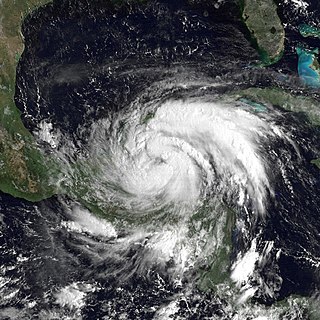
WHurricane Gert was a large tropical cyclone that caused extensive flooding and mudslides throughout Central America and Mexico in September 1993. The seventh named storm and third hurricane of the annual hurricane season, Gert originated as a tropical depression from a tropical wave over the southwestern Caribbean Sea on September 14. The next day, the cyclone briefly attained tropical storm strength before moving ashore in Nicaragua and proceeding through Honduras. It reorganized into a tropical storm over the Gulf of Honduras on September 17, but weakened back to a depression upon crossing the Yucatán Peninsula. Once over the warm waters of the Bay of Campeche, Gert quickly strengthened into a Category 2 hurricane by September 20. The hurricane made a final landfall on the Gulf Coast of Mexico near Tuxpan, Veracruz, with peak winds of 100 mph (155 km/h). The rugged terrain disrupted the cyclone's structure; Gert entered the Pacific Ocean as a depression near the state of Nayarit on September 21, where it briefly redeveloped a few strong thunderstorms before dissipating at sea five days later.
 W
WHurricane Greta, later Hurricane Olivia, was one of ten named Atlantic hurricanes to cross over Central America into the eastern Pacific while remaining a tropical cyclone. The seventh named storm of the 1978 Atlantic hurricane season, Greta formed from a tropical wave just northwest of Trinidad on September 13, and despite being in a climatologically unfavorable area, gradually intensified while moving west-northwestward. On September 16, it became a hurricane south of Jamaica. Two days later, the well-defined eye approached northeastern Honduras but veered to the northwest. After reaching peak winds of 130 mph (215 km/h) that day, Greta weakened while paralleling the northern Honduras coast just offshore. On September 19, it made landfall on Belize near Dangriga and quickly weakened into a tropical depression while crossing Guatemala and southeastern Mexico. After entering the eastern Pacific, the system re-intensified into a hurricane and was renamed Olivia, the eighteenth named storm of the 1978 Pacific hurricane season which weakened before landfall and dissipated over Chiapas on September 23.
 W
WTropical Storm Harvey was the final tropical cyclone in a record-breaking string of eight consecutive storms that failed to attain hurricane intensity. The eighth tropical cyclone and eighth named storm of the 2011 Atlantic hurricane season, Harvey developed from a tropical wave in the western Caribbean Sea on August 19. It moved over warm waters in the vicinity of Central America. Later on August 19, the system strengthened into Tropical Storm Harvey while just offshore Honduras. Additional organization occurred and Harvey attained its peak intensity of 65 mph (100 km/h) prior to coming ashore Belize on August 20. Harvey weakened to a tropical depression on August 21, but re-intensified to a tropical storm after emerging into the Bay of Campeche. Early on August 22, it made landfall in Veracruz, then weakened and dissipated several hours later.
 W
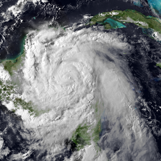
WHurricane Hattie was one of the strongest and deadliest tropical cyclones of the 1961 Atlantic hurricane season, reaching a peak intensity as a Category 5 hurricane. The ninth tropical storm, seventh hurricane, fifth major hurricane, and second Category 5 of the season, Hattie originated from an area of low pressure that strengthened into a tropical storm over the southwestern Caribbean Sea on October 27. Moving generally northward, the storm quickly became a hurricane and later major hurricane the following day. Hattie then turned westward west of Jamaica and strengthened into a Category 5 hurricane, with maximum sustained winds of 165 mph (270 km/h). It weakened to Category 4 before making landfall south of Belize City on October 31. The storm turned southwestward and weakened rapidly over the mountainous terrain of Central America, dissipating on November 1.
 W
WTropical Storm Hermine caused significant flooding in Mexico during September 1980. The eleventh tropical cyclone and eight named storm of the 1980 Atlantic hurricane season, Hermine developed from a tropical wave that emerged into the Atlantic from the west coast of Africa on September 11. After uneventfully crossing the Atlantic Ocean, the system developed a well-defined circulation while in the Caribbean Sea on September 20 and was then classified as a tropical depression. After becoming a tropical cyclone, the depression steadily strengthened as it tracked nearly due westward. By September 21, it strengthened into Tropical Storm Hermine and brushed the northern coast of Honduras shortly thereafter. It nearly became a hurricane before it made landfall in Belize on September 22. After weakening over the Yucatan Peninsula, Hermine restrengthened to near-hurricane status again over the Gulf of Mexico before making landfall in the Mexican state of Veracruz. Hermine steadily weakened inland and eventually dissipated on September 26.
 W
WHurricane Iris was a small, but powerful tropical cyclone that caused widespread destruction in Belize. Iris was the second-strongest storm of the 2001 Atlantic hurricane season, behind Hurricane Michelle. It was the ninth named storm, fifth hurricane, and third major hurricane of the year, forming from a tropical wave on October 4 just southeast of Barbados. It moved westward through the Caribbean, intensifying into a tropical storm on October 5 south of Puerto Rico, and into a hurricane on the following day. While passing south of the Dominican Republic, Iris dropped heavy rainfall that caused landslides, killing eight people. Later, the hurricane passed south of Jamaica, where it destroyed two houses. On reaching the western Caribbean Sea, Iris rapidly intensified into a Category 4 on the Saffir–Simpson scale. A small hurricane with an eye of only 7 mi (11 km) in diameter, Iris reached peak winds of 145 mph (230 km/h) before making landfall in southern Belize near Monkey River Town on October 9. The hurricane quickly dissipated over Central America, although its remnants contributed to the formation of Tropical Storm Manuel in the eastern Pacific Ocean. The hurricane caused severe damage—destroying homes, flooding streets, and leveling trees—in coastal towns south of Belize City.
 W
WHurricane Janet was the most powerful tropical cyclone of the 1955 Atlantic hurricane season and one of the strongest Atlantic hurricanes on record. Janet was also the first named storm to have 1,000 deaths and the first Category 5 named storm to be retired. The eleventh tropical storm, ninth hurricane, and fourth major hurricane of the year, Janet formed from a tropical wave east of the Lesser Antilles on September 21. Moving westward across the Caribbean Sea, Janet fluctuated in intensity, but generally strengthened before reaching its peak intensity as a Category 5 hurricane with winds of 175 mph (282 km/h). The intense hurricane later made landfall at that intensity near Chetumal, Mexico on September 28. After weakening over the Yucatán Peninsula, it moved into the Bay of Campeche, where it slightly strengthened before making its final landfall near Veracruz on September 29. Janet quickly weakened over Mexico's mountainous terrain before dissipating on September 30.
 W
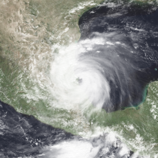
WHurricane Karl was the most destructive tropical cyclone on record to strike the Mexican state of Veracruz. The eleventh tropical storm, sixth hurricane, and fifth and final major hurricane of the 2010 Atlantic hurricane season, Karl formed from an area of low pressure which had formed off of the northern coast Venezuela on September 11. It crossed the Caribbean and was upgraded to Tropical Storm Karl on September 14. The cyclone made landfall on the Yucatan Peninsula of Mexico as a strong tropical storm, and then rapidly strengthened in the Bay of Campeche before it made landfall near the city of Veracruz, on the central Mexican Gulf coast, as a major hurricane. This marked the first known time that a major hurricane existed in the Bay of Campeche. Afterwards, the storm rapidly weakened over the mountains of Mexico and dissipated on September 18.
 W
WTropical Storm Katrina was a short-lived, weak tropical cyclone that produced minor damage across areas previously devastated by Hurricane Mitch in 1998. Forming out of a broad area of low pressure in the southwestern Caribbean Sea on October 28, 1999, the disorganized tropical storm made landfall near Puerto Cabezas, Nicaragua with winds of 40 mph (65 km/h) on October 30 before weakening to a tropical depression. The remnants of the storm persisted until November 1, at which time it was absorbed by a cold front on the northern end of the Yucatán Peninsula.
 W
WHurricane Keith was an Atlantic hurricane in October 2000 that caused extensive damage in Central America, especially in Mexico and Belize. It was the fifteenth tropical cyclone, eleventh named storm, and seventh hurricane of the 2000 Atlantic hurricane season. Keith developed as a tropical depression from a tropical wave in the western Caribbean Sea on September 28. The depression gradually strengthened, and became Tropical Storm Keith on the following day. As the storm tracked westward, it continued to intensify and was upgraded to a hurricane on September 30. Shortly thereafter, Keith began to rapidly deepen, and peaked as a Category 4 hurricane less than 24 hours later. Keith then began to meander erratically offshore of Belize, which significantly weakened the storm due to land interaction. By late on October 2, Keith made landfall in Ambergris Caye, Belize as a minimal hurricane. It quickly weakened to a tropical storm, before another landfall occurred near Belize City early on the following day. While moving inland over the Yucatán Peninsula, Keith weakened further, and was downgraded to a tropical depression before emerging into the Gulf of Mexico on October 4. Once in the Gulf of Mexico, Keith began to re-strengthen and was upgraded to a tropical storm later that day, and a hurricane on the following day. By late on October 5, Keith made its third and final landfall near Tampico, Tamaulipas, Mexico as a moderately strong Category 1 hurricane. The storm quickly weakened inland and dissipated as a tropical cyclone by 24 hours after landfall.
 W
WTropical Storm Laura was the final storm in the active 1971 Atlantic hurricane season. It formed on November 12 in the western Caribbean Sea, and reached winds of 70 mph (120 km/h) as it approached western Cuba. Across the island, Laura produced heavy rainfall, peaking at 32.5 inches (83 cm). The resulting flooding killed one person and caused crop damage. 26,000 people were forced to evacuate their homes. Initially, Laura was forecast to move across the island and impact the southern United States, but it executed a small loop and turned to the southwest. The storm moved ashore on Belize, one of only four November storms to affect the country. Little impact occurred during Laura's final landfall, and it dissipated on November 22 over central Guatemala.
 W
WHurricane Marco was the first of two tropical cyclones to threaten the Gulf Coast of the United States within a three-day period, with the other being Hurricane Laura. The thirteenth named storm and third hurricane of the record-breaking 2020 Atlantic hurricane season, Marco developed from a fast-moving tropical wave west of the Windward Islands and south of Jamaica on August 20. The fast motion of the wave inhibited intensification initially, but as the wave slowed down and entered a more favorable environment, the system developed into a tropical depression, which in turn rapidly intensified into a strong tropical storm. Due to strong wind shear, Marco's intensification temporarily halted; however, after entering the warm waters of the Gulf of Mexico on August 23, Marco briefly intensified into a hurricane, only to quickly weaken later that evening due to another increase in wind shear. Marco made landfall near the mouth of the Mississippi River on the evening of August 24, as a weak tropical storm and subsequently weakened to a tropical depression before becoming a remnant low early on the next morning. Marco's remnants subsequently dissipated on August 26.
 W
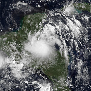
WHurricane Nana was a minimal Category 1 hurricane that caused moderate damage across the countries of Belize and Guatemala in early September 2020. The sixteenth tropical cyclone, fourteenth named storm, and the fifth hurricane of the record-breaking 2020 Atlantic hurricane season, Nana originated from a tropical wave near the Lesser Antilles. The National Hurricane Center (NHC) began tracking the wave on August 27, giving it a low chance of formation. Contrary to predictions, the wave rapidly organized, though data failed to locate a closed circulation, and the system was not designated a tropical cyclone. However, the system continued organizing, and data from a hurricane hunter aircraft recorded tropical storm force winds along with a closed circulation; the NHC subsequently named the system Tropical Storm Nana on September 1. Nana rapidly intensified that day, though wind shear increased early the next day, preventing the storm from intensifying further. However, early on September 3, reconnaissance aircraft found that Nana had strengthened into a hurricane just before making landfall in Southern Belize. After landfall, it began to rapidly weaken. Early on September 4, its low-level center dissipated and it degenerated into a mid-level remnant low. The remnants moved into the Eastern Pacific, where they reformed into Tropical Storm Julio.
 W
WHurricane Richard was a damaging hurricane that affected areas of Central America in October 2010. It developed on October 20 from an area of low pressure that had stalled in the Caribbean Sea. The system moved to the southeast before turning to the west. The storm slowly organized, and the system intensified into a tropical storm. Initially, Richard only intensified slowly in an area of week steering currents. However, by October 23, wind shear diminished, and the storm intensified faster as it headed toward Belize. The next day, Richard intensified into hurricane status, and further into its peak intensity as a Category 2 hurricane, reaching maximum winds of 100 mph (150 km/h). The hurricane made its only landfall on Belize at peak intensity. Over land, Richard quickly weakened, and later degenerated into a remnant low on October 25.
 W
WHurricane Wilma was the most intense tropical cyclone ever recorded in the Atlantic basin, and the second-most intense tropical cyclone recorded in the Western Hemisphere, after Hurricane Patricia in 2015. Part of the record-breaking 2005 Atlantic hurricane season, which included three of the ten most intense Atlantic hurricanes ever, Wilma was the twenty-second storm, thirteenth hurricane, sixth major hurricane, fourth Category 5 hurricane, and the second-most destructive hurricane of the 2005 season. A tropical depression formed in the Caribbean Sea near Jamaica on October 15, headed westward, and intensified into a tropical storm two days later, which abruptly turned southward and was named Wilma. Wilma continued to strengthen, and eventually became a hurricane on October 18. Shortly thereafter, explosive intensification occurred, and in only 24 hours, Wilma became a Category 5 hurricane with wind speeds of 185 mph (298 km/h).
 W
WHurricane Eta was a devastating Category 4 hurricane that wreaked havoc across parts of Central America in early November 2020. The record-tying twenty-eighth named storm, twelfth hurricane and fifth major hurricane of the extremely active 2020 Atlantic hurricane season, Eta originated from a vigorous tropical wave in the eastern Caribbean Sea on October 31. The system rapidly organized as it progressed west, with the cyclone ultimately becoming a Category 4 hurricane on November 3. With a peak intensity of 150 mph (240 km/h) and 923 mbar, it was the third most intense November Atlantic hurricane on record behind the 1932 Cuba hurricane and Hurricane Iota just two weeks later. Some weakening took place as the system made landfall near Puerto Cabezas, Nicaragua, late that same day. Eta rapidly weakened to a tropical depression as it meandered across Central America for two days before moving north over water. It later reorganized over the Caribbean as it accelerated toward Cuba on November 7. Over the next five days, the system moved erratically, moving through the Florida Keys and stalling in the southern Gulf of Mexico, its intensity fluctuating along the way. After briefly regaining hurricane strength it weakened once more and accelerated across the Southeastern United States on November 12. It soon became extratropical and dissipated off the Eastern United States the next day.