 W
WBåtvika is a cove at the southern part of the island of Jan Mayen. It is located at the southeastern side of the island, in the southwestern part of Rekvedbukta, northeast of Kapp Traill. The settlement Olonkinbyen is located on the plain northeast of the cove, and Båtvika is the settlement's nearest harbour.
WEggøybukta is a bay located on the island of Jan Mayen. It is located west of Eggøya, on the southern side and central part of Jan Mayen.
 W
WEggøykalven is an islet south of the peninsula of Eggøya at the southern part of Jan Mayen. It is located just about 80 meters west of the point of Eggøyodden, and southeast of the bay Eggøybukta. The islet was earlier much higher, but has been significantly worn down by the ocean.
 W
WEngelskbukta is a broad, open bay mid-way up the west coast of the Norwegian island of Jan Mayen. It lies between Kapp Rudsen and Kvalrossen, comprising Kvalrossbukta and Tømmerbukta. Presumably this is where the English resorted to in 1616, when they sent their first whaling ships to the island. The Dutch whalers called it Noordbaai and used it for one of their two main whaling stations. In 1632 two Basque whaling ships plundered the station, causing the Dutch to send a wintering party of seven men in 1633–34. All perished.
WGouwenaerbåen is a 10 m (33 ft) shoal or reef southeast of Eggøya, on the southern coast of the island of Jan Mayen. It is named after the Dutch seafarer Jacob de Gouwenaer, who was master of the Orangienboom in 1614, when he had first come upon the island. His name had originally been attached to Rekvedbukta.
WHoepstockbukta is a small cove on the western coast of the Norwegian island of Jan Mayen and is named after Mathijs Jansz. Hoepstock, a Rotterdam whaler, who was the first to use the bay in 1616. The cove is shown on Joan Blaeu's 1662 map of the island.
 W
WHornbækbukta is a bay at the southeastern side of the Norwegian island of Jan Mayen. It has a width of 2.2 kilometers, and extends from the headland of Fugleodden to the southwest, to Kapp Wien to the northeast. The bay is named after hydrographer Helge Hornbæk.
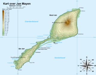
WHøybergodden, officially Hoybergodden, is the most western point of the volcanic island of Jan Mayen. The name refers to the nearby volcanic crater of Hoyberg.
WJamesonbukta is a bay in the island of Jan Mayen. It is located east of Eggøya, on the southern side and central part of Jan Mayen.
 W
WThe Jan Mayen hotspot is a proposed volcanic hotspot responsible for the volcanic activity that has formed the island of Jan Mayen in the northern Atlantic Ocean.
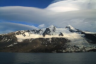
WKapp Muyen is a cape just 107 m (350 ft) west of Beerenberg, the stratovolcano which forms the northeastern end of the Norwegian island of Jan Mayen. The point is named after the Dutch whaling master Willem Cornelisz. van Muyden, who was among the first to catch whales at Jan Mayen.
 W
WThe Kapp Toscana Group is a geologic group in Svalbard and Jan Mayen in the Barents Sea, Norway.
WKapp Traill is a headland at the southern part of the island of Jan Mayen. It defines the southwestern extension of the bay Rekvedbukta, at the southeast side of the island. The distance between Kapp Traill and Kapp Wien further southwest is about three nautical miles. The point is named after British zoologist Thomas Stewart Traill.
WKapp Wien is a headland at the southeastern side of the island of Jan Mayen, about halfway between Olonkinbyen and Sørkapp. It defines the northeastern extension of the bay Hornbækbukta.
 W
WKjerulf Glacier is a glacier in Jan Mayen. It begins at the Hakluyttoppen slope, in the outer crater edge of the Beerenberg. The Kjerulf Glacier and both its neighbors, the Weyprecht Glacier in the west and the Svend-Foyn Glacier in the east, are the most active glaciers in the island.
WMaria Muschbukta is an open bay between Fulgeberget and Kvalrossen, on the western coast of the Norwegian island of Jan Mayen. It is named after the shipowner Maria Musch. She was a member of the Kleine Noordse Compagnie, which sent a ship to Jan Mayen in 1616 as part of early Dutch whaling. This ship was the first to use the bay to hunt whales. The name is shown on Joan Blaeu's 1662 map of the island.
 W
WNordkapp is the northernmost point of Jan Mayen, located at the northeastern extreme of the island. The cape is some 490 km east of eastern Greenland, 880 km west northwest of mainland Norway (Lofoten) and 950 km southwest of Sørkapp, Svalbard.
WNordlaguna is a lagoon on the island of Jan Mayen. It is the second largest lake of Jan Mayen, after Sørlaguna, and is located in the central part of the island, near the bay of Stasjonsbukta.
 W
WOlonkinbyen is one of the two settlements on the Norwegian island of Jan Mayen. It was named after the explorer Gennady Olonkin.
 W
WPuppebu is the second largest settlement on the Norwegian island Jan Mayen. The hamlet is bordered by the Bay of Walrus. Although Puppebu does not exceed 3 temporary inhabitants, there is a small stone road, called Jan Mayenveien, that runs from Puppebu on the north of the island to Olonkinbyen. Every month, a ship takes supplies to the town, but during the winter season it cannot be accessed from the bay because large blocks of ice form in the water.
WRekvedbukta is an open bay on the central southern coast of the island of Jan Mayen, about eight nautical miles long.
WRooberg is a 50 m (165 ft) hill at Sjuhollendarbukta, a bay on the northwestern coast of the island of Jan Mayen. The hill is often mentioned during the Dutch wintering at Jan Mayen in 1633–34.
WRudolftoppen is a mountain on the island of Jan Mayen. It has a height of 769 m.a.s.l., and is the highest peak in the southern part of the island.
WSjuhollendarbukta is a bay on the western coast of the island of Jan Mayen. The Austrian Emil von Wohlgemuth (1886), who surveyed Jan Mayen, named the bay 7 Holländer Bucht, mistakenly believing it was the site of the wintering of seven Dutch whalers in 1633–34.
WSørkapp is the southernmost point of Jan Mayen, located at the southern extreme of the island. The cape is some 455 km east of eastern Greenland, 910 km west northwest of mainland Norway (Lofoten) and 550 km northeast of northeastern Iceland.
WSørlaguna is a lagoon on the island of Jan Mayen. It is the largest lake of Jan Mayen, and is located in the central part of the island, near the bay of Rekvedbukta.
WTiteltbukta is a bay on the northwestern coast of the Norwegian island of Jan Mayen. The name originates from the establishment of ten "tents", in reality wood and brick structures, as a basic whaling station. This was set up in 1624 by Dutch whalers to lodge the men who flensed the whales. The Dutch also called it Zuidbaai, in contrast to the other on the island, to the north at Engelskbukta).
WTrollsletta is a coastal plain on the North Arctic Ocean island of Jan Mayen.
 W
WWeyprecht Glacier is a glacier in Jan Mayen. It is the longest glacier located in the Beerenberg area.