 W
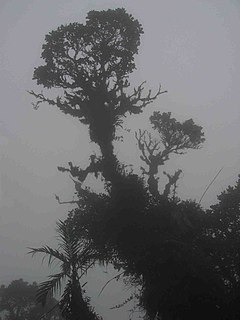
WThere are currently 30 National Parks of Costa Rica, which are managed under the umbrella of SINAC, a department of Costa Rica's Ministry of Environment and Energy (MINAE). All told, Costa Rica's protected areas encompass more than 25% of the country's total land area. Many of these protected areas are national parks.
 W
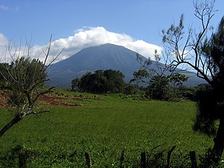
WArenal Volcano National Park is a Costa Rican national park in the central part of the country, part of the Arenal Huetar Norte Conservation Area. The park encompasses the Arenal Volcano, which "was" the most active in the country, which had previously been believed to be dormant until a major eruption in 1968. It neighbors Lake Arenal, which is the site of the country's largest hydroelectricity project, the Lake Arenal Dam.
 W
WBarbilla National Park is a National Park in the Caribbean La Amistad Conservation Area of Costa Rica located on the eastern slopes of the Cordillera de Talamanca. It protects forests as well as Laguna Ayil and Cerro Tigre and the Dantas River watershed, covering parts of both Cartago and Limón Provinces. It was initially established in 1982.
 W
WBarra Honda National Park is a national park in the western part of Costa Rica, which forms part of the Tempisque Conservation Area about 12 km (7.5 mi) from the Tempisque River. It was created in 1974 to protect its famous cave systems, under the Barra Honda Peak which was formed when islets from the Miocene Era were raised above the plains of the river. The caves and waterways there today were then carved out by the action of rain filtering through the limestone over 70 million years or more.
 W
WBraulio Carrillo National Park is a National Park in Heredia Province and San José Province, in central Costa Rica It is part of the Central Conservation Area.
 W
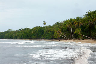
WCahuita National Park is a terrestrial and marine national park in the Caribbean La Amistad Conservation Area of Costa Rica located on the southern Caribbean coast in Limón Province, connected to the town of Cahuita. It protects beaches and lowlands and attracts tourists and other visitors who are able to snorkel in the protected marine area which contains the coralline reefs, as well as being a nesting ground for sea turtles. It covers a land area of 2,732 acres (1,106 ha), and a marine area of 55,200 acres (22,300 ha). February through April typically have the best underwater visibility. This is also one of the nicest and least developed beaches in Costa Rica.
 W
WCarara National Park is a national park in the Central Pacific Conservation Area located near the Pacific coast of Costa Rica. It was established on 27 April 1978 as a biological reserve, but its growing popularity after 1990 forced the government to upgrade its category to national park in November 1998.
 W
WChirripó National Park is a national park of Costa Rica, encompassing parts of three provinces: San José, Limón and Cartago. It was established in 1975.
 W
WCocos Island is an island in the Pacific Ocean administered by Costa Rica, approximately 550 km southwest of the Costa Rican mainland. It constitutes the 11th of the 13 districts of Puntarenas Canton of the Province of Puntarenas. With an area of approximately 23.85 km2 (9.21 sq mi), the island is more or less rectangular in shape. It is the southernmost point on the North American continent if outer islands are included.
 W
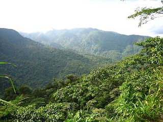
WCorcovado National Park is a National Park on the Osa Peninsula in Osa Canton, southwestern Costa Rica, which is part of the Osa Conservation Area. It was established on 24 October 1975, and encompasses an area of 424 square kilometres (164 sq mi). It is the largest park in Costa Rica and protects about a third of the Osa Peninsula. It is widely considered the crown jewel in the extensive system of national parks and biological reserves spread across the country. The ecological variety is quite stunning. National Geographic has called it "the most biologically intense place on Earth in terms of biodiversity". Not only is the park very popular with tropical ecologists, a visitor can expect to see an abundance of wildlife.
 W
WThe Diriá National Park, until 2004 the Diriá National Forest Wildlife Refuge, is a National Park of Costa Rica south of Santa Cruz in the Guanacaste Province, and forms part of the Tempisque Conservation Area. It protects both dry and at higher elevations humid tropical forest in the central highlands of the Nicoya Peninsula, including the watersheds of the Diriá, Tigre, Verde and Enmedio rivers which have been created a terrain of deep valleys with steep slopes.
 W
WGuanacaste National Park, in Spanish Parque Nacional Guanacaste, is part of the Area de Conservación Guanacaste World Heritage Site, is a National Park in the northern part of Costa Rica, from the slopes of the Orosí and Cacao volcanoes west to the Interamerican Highway where it is adjacent to the Santa Rosa National Park. It was created in 1989, partially due to the campaigning and fund-raising of Dr. Daniel Janzen to allow a corridor between the dry forest and rain forest areas which many species migrate between seasonally. The park covers an area of approximately 340 square kilometers, and includes 140 species of mammals, over 300 birds, 100 amphibians and reptiles, and over 10,000 species of insects that have been identified. It was this high density of bio-diversity that encouraged the Costa Rican government to protect this area. The Guanacaste National Park weaves the neighboring Santa Rosa National Park with the high altitude forests of the two volcanoes, Orosi and Cacao, and the rainforest of the Caribbean in the country's north.
 W
WIrazú Volcano National Park, or in Spanish the Parque Nacional Volcán Irazú, is a National Park in the Central Conservation Area of Costa Rica that encompasses the area around the Irazú Volcano in Cartago Province which incorporates what used to be the Ruben Torres Rojas Forest Reserve now called the Prusia Forest Reserve. The volcano is still active although the last major eruptions were between 1963 and 1965, with occasional minor eruptions and some small lava flows since that time.
WJuan Castro Blanco National Park is a National Park, part of the Arenal Huetar Norte Conservation Area, in the northern part of Costa Rica.
 W
WThe La Amistad International Park, or in Spanish Parque Internacional La Amistad, formerly the La Amistad National Park, is a Transboundary Protected Area in Latin America, management of which is shared between Costa Rica and Panama, following a recommendation by UNESCO after the park's inclusion in the World Heritage Site list.
 W
WLa Cangreja National Park, until 2002 the Cerro de la Cangreja Protected Zone, is a National Park in the Puriscal Canton of San José Province, in west-central Costa Rica.
 W
WLos Quetzales National Park, located 97 kilometers from San Isidro de El General, Costa Rica, it was created in 2006 by decree 32981-MINAE. It is managed under the Central Conservation Area of the National System of Conservation Areas.
WManuel Antonio National Park, in Spanish the Parque Nacional Manuel Antonio, is a small National Park in the Central Pacific Conservation Area located on the Pacific coast of Costa Rica, just south of the city of Quepos, Puntarenas, and 132 km (82 mi) from the national capital of San José. Established in 1972 with a land area enumerating 1,983 ha, it is considered the smallest of any Costa Rican national park. The park caters to as many as 150,000 visitors annually, and is well known for its beautiful beaches and hiking trails. In 2011, Manuel Antonio was listed by Forbes as among the world's 12 most beautiful national parks.
WMiravalles Jorge Manuel Dengo National Park, is a national park and nature reserve in the northwest part of Costa Rica, which forms part of the Arenal Tempisque Conservation Area. The site contains the Miravalles Volcano, which is still active although the last recorded eruption was only of steam vents in 1946.
 W
WPalo Verde National Park, is a national park of Costa Rica, part of the Arenal Tempisque Conservation Area, that contains much of the area of the valley of the Tempisque River and covers an area of 45,492 acres in Guanacaste Province, 30 km west of Canas. The surrounding region is mostly tropical dry forests, and the park concentrates on conserving vital floodplain, marshes, limestone ridges, and seasonal pools from the encroachment of civilization which was putting the ecology of the area at risk.
WPiedras Blancas National Park is a national park part of the Osa Conservation Area. It is found in the Puntarenas Province of southern Costa Rica near the town of La Gamba. It protects rainforests and beaches near the Golfo Dulce on the Pacific Coast. It used to operate as part of the Corcovado National Park called the Esquinas Sector from 1991 before becoming a separate park in 1999. Until the mid-1990s, much of the forest in the park was severely endangered by logging.
 W
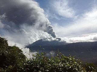
WPoás Volcano National Park, in Spanish Parque Nacional Volcán Poás, is a National Park in Costa Rica that covers an area of approximately 65 square kilometres ; the summit is 2,700 metres (8,900 ft). It was established on 25 January 1971. Depending on conditions, visitors can walk all the way to the edge of the main crater, but on 13 April 2017 the park was closed to visitors due to an explosive eruption on the evening of 12 April. Still further eruptions, including on Easter, 16 April, caused the park to be closed until August 2018.
WRincón de la Vieja National Park, is a National Park in Guanacaste Province of the northwestern part of Costa Rica.
 W
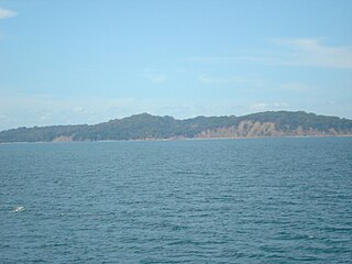
WSan Lucas Island National Park is an island located off the Pacific shore of Costa Rica in the Gulf of Nicoya. It is part of the Puntarenas district of Puntarenas Canton of the province of Puntarenas.
 W
WSanta Rosa National Park, is a national park, in Guanacaste Province, northwestern Costa Rica, it was created in 1966 by decree 3694.
 W
WTapantí - Cerro de la Muerte Massif National Park,, is a National Park in the Central Conservation Area of Costa Rica located on the edge of the Talamanca Range, near Cartago. It protects forests to the north of Chirripó National Park, and also contains part of the Orosí River. The area known as Cerro de la Muerte Massif was added to the park on January 14, 2000.
 W
WTenorio Volcano National Park is a National Park in the northern part of Costa Rica, which forms part of the Arenal Tempisque Conservation Area. The jewel of the National Park is the Tenorio Volcano, from which it receives its name. The volcano was made part of the National Park in 1995 and is located about 26 miles northeast from the town of Fortuna in the Guanacaste Province.
 W
WTortuguero National Park is a national park in the Limón Province of Costa Rica. It is situated within the Tortuguero Conservation Area of the northeastern part of the country. Despite its remote location, reachable only by airplane or boat, it is the third-most visited park in Costa Rica. The park has a large variety of biological diversity due to the existence within the reserve of eleven different habitats, including rainforest, mangrove forests, swamps, beaches, and lagoons. Located in a tropical climate, it is very humid, and receives up to 250 inches (6,400 mm) of rain a year.
 W
WTurrialba Volcano National Park, or in Spanish the Parque Nacional Volcan Turrialba is a National Park in the Central Conservation Area of Costa Rica that encompasses the area around the Turrialba Volcano in Cartago Province.