 W
WCakung is a subdistrict (kecamatan) of East Jakarta, Indonesia. The subdistrict is roughly bounded with Bekasi Raya Road to the west, Bekasi Raya Road - Petukangan canal to the north, portion of Cakung river to the east, and Jakarta-Bandung-Surabaya railway to the south. Large area in Cakung is allotted to industrial or agricultural use. The Pulogadung industrial complex is located in the Subdistrict. The subdistrict is served by Jakarta's outer ringroad.
 W
WCempaka Putih is a subdistrict of Central Jakarta, Indonesia. Cempaka Putih is roughly bounded by Jenderal Ahmad Yani bypass highway to the east, Pramuka boulevard to the south, Letjend Suprapto boulevard to the north, and a railway line to the west. The name "Cempaka Putih" derived from flowering plant white champaca.
 W
WCengkareng is a district (kecamatan) on West Jakarta, Indonesia. The Duri-Tangerang railway and Tangerang-Jakarta railway passes through Cengkareng.
 W
WCilincing is a historic neighborhood in the northern coast area of Jakarta, Indonesia. The neighborhood is sandwiched between the Port of Tanjung Priok to the west and River Titram to the east. Cilincing was made one of the subdistrict of North Jakarta, encompassing a huge area which includes Marunda and the non-coastal hinterland.
 W
WCiracas is a subdistrict (kecamatan) of East Jakarta, one of the five administrative cities which form Jakarta, Indonesia. Ciracas is the southernmost subdistrict of Jakarta. The area of Cibubur Scout's camping ground complex is located partly within the Ciracas subdistrict, although the main camping ground area is located in Cipayung subdistrict. The boundaries of Ciracas Subdistrict are Cipinang River to the west, Cipinang River - Jambore Road to the south, Jagorawi Tollroad to the east, and Kelapa Dua Wetan Road to the north.
 W
WDuren Sawit is a district (kecamatan) of East Jakarta, Indonesia. The rough boundaries of Duren Sawit are I. Gusti Ngurah Rai road to the north, Kali Sunter to the west, and Kali Malang to the south. The district borders the districts of Jatinegara to the west, Cakung and Pulo Gadung to the north, and Makasar to the south, and Bekasi to the east.
 W
WGambir is a district of Central Jakarta, Indonesia. It is characterized by many historic buildings from the colonial era. Gambir District is the location of many political and administrative center of Jakarta and Indonesia. The Merdeka Palace, the National Museum, the headquarters of the Indonesian Scout Movement and the Merdeka Square are located in Gambir.
 W
WGrogol Petamburan is a subdistrict of West Jakarta, Indonesia, roughly bounded by the West Flood Canal to the east, Angke Canal to the west and to the north, and Jakarta-Merak Tollway to the south. It has an area 1,130 ha. As of 2004, the use of the land was 58.0% for housing, 12.5% for offices, 3.8% in parkland, and 2.2% in farmland with the remainder in other uses or idle.
 W
WJatinegara is one of the districts (Kecamatan) of East Jakarta, Indonesia. The name also refers to the larger, historic area of the colonial town of Meester Cornelis. Established in the 17th century, Jatinegara is one of the oldest areas in Jakarta, and contains a number of buildings from the colonial period.
 W
WKalideres is a subdistrict of West Jakarta, Indonesia and is the westernmost subdistrict of Jakarta. Kalideres covers 3,023.36 hectares and is bounded by Penjaringan subdistrict to the north, Cengkareng subdistrict to the east and Tangerang Regency to the south and west.
 W
WKebayoran Baru is a district of South Jakarta, Indonesia. The name of the district was derived from an area which was developed in the post-war period as a new suburb town of Jakarta, Kebayoran Baru. Kebayoran Baru was the last residential area to be developed by the Dutch colonial administration. The urban planning was laid in a concept of the Garden city movement, consisting of a well-planned residential area, a shopping center, and a business district, supported with civic facilities e.g. schools, places of worship, hospitals, and parks. Many important governmental institutions are located in Kebayoran Baru, such as the Indonesia Stock Exchange building, the ASEAN Secretariat building, the Criminal Investigation Agency of the National Police, and the City Hall of South Jakarta. Sudirman Central Business District is also located in Kebayoran Baru sub-district.
 W
WKebayoran Lama is a subdistrict of South Jakarta, Indonesia. The rough boundaries of Kebayoran Lama is Kebayoran Lama Road - Palmerah Barat Road to the north, Grogol River to the east, Jakarat Outer Ring Road to the south, and Pesanggrahan River to the west.
 W
WKebon Jeruk is a subdistrict (kecamatan) of West Jakarta, Indonesia. Kebon Jeruk is roughly bounded by Kali Pesanggrahan creek to the west, Kebayoran Lama Road to the south, Daan Mogot Road to the north, and Rawa Belong - Batu Sari Road to the east. The area is approximately 18 square km.
 W
WKelapa Gading or also known as KG, Gading, is a district of North Jakarta, Jakarta, Indonesia. Kelapa Gading neighborhood is known to the local populates as a city within a city, due to the integrated residential-commercial planning, and the supporting facilities.
 W
WKemayoran is a district of Central Jakarta, Jakarta in Indonesia. The area was best known as the location of the former Kemayoran Airport, although the area of the former airport itself is actually located in two district, the northern part lies on the district of Pademangan, North Jakarta while the southern part lies on the district of Kemayoran, Central Jakarta. Jakarta International Expo is built on 44 hectares of land of former airport, where Jakarta Fair is held annually. Kemayoran has been transforming as a new CBD area of Jakarta.
 W
WKembangan is a district in West Jakarta, Indonesia. Kembangan is bounded by Pesanggrahan Subdistrict to the south, Tangerang Regency to the south and west, Cengkareng Subdistrict to the north, and Kebon Jeruk Subdistrict to the east. The City Hall of West Jakarta is located in this district.
 W
WMatraman is a subdistrict (kecamatan) of East Jakarta, Indonesia. Matraman is the smallest Subdistrict of East Jakarta. The boundary of Matraman is Bekasi Barat Raya Road to the south, Prof Wiyoto Witono MSc Highway to the east, Pramuka Road to the north, and Ciliwung River to the west.
 W
WMenteng is a district of Central Jakarta, one of the administrative municipalities in the special capital territory of Jakarta, Indonesia.
 W
WPademangan is a subdistrict of North Jakarta, Indonesia. The area of Pademangan stretches from the Sunda Kelapa Harbor on the east to the western area of Tanjung Priok Harbor to the east. Pademangan also covers the area that was formerly known as Kemayoran Airport. Geographically, Pademangan is a low plain with average height of 75 centimeter above the sea level.
 W
WPalmerah is a subdistrict of West Jakarta, Indonesia. The Subdistrict is roughly bounded by Jakarta-Merak Tollway to the north, Batusari - Rawa Belong Road to the west, Palmerah Barat - Palmerah Utara Road to the south, and Aipda K. Sasuit Tubun Road - Western Flood Canal to the east.
 W
WPasar Minggu is a district of South Jakarta, Jakarta, Indonesia. The area is known for its traditional Sunday market, famous for the fruit market. Historically, Pasar Minggu is a fruit cultivation area developed by the Dutch government during the colonial period. The central point of the cultivation area is the traditional market of Pasar Minggu, located in what is now Pasar Minggu Kelurahan. Teak forest could also be found in Pasar Minggu district, notably around Jati Padang Kelurahan. Most of these areas has been converted into residential area as Jakarta grow southward.
 W
WPenjaringan is a subdistrict of North Jakarta, Indonesia. It is the westernmost Subdistrict of North Jakarta. Muara Angke port and the mouth of Sunda Kelapa Port is located within Penjaringan. Penjaringan contains the remnants of the original mangrove forest of Jakarta, some is protected by the government. Penjaringan Subdistrict is crisscrossed with water draining channels, canals, and water reservoirs to protect the land from sea flooding. The Cengkareng Drain, part of Jakarta's flood control system, flows to the sea through this subdistrict.
 W
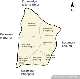
WPulo Gadung is a subdistrict (kecamatan) of East Jakarta, Indonesia. The boundary of Pulo Gadung is Bekasi Timur Raya - I Gusti Ngurah Rai Road to the south, Bekasi Raya Road to the east, Perintis Kemerdekaan Road to the north, and Jenderal Ahmad Yani Road to the west.
 W
WSawah Besar is a subdistrict (kecamatan) of Central Jakarta, Indonesia. The neighborhoods within the subdistrict are among the most historic subdistrict in Jakarta, containing the 1820-established Pasar Baru, the colonial administrative center of Weltevreden, as well as the old course of the Ciliwung. Many colonial landmarks are located in the subdistrict, e.g. the Lapangan Banteng, the A.A. Maramis Building, and the Jakarta Cathedral.
 W
WSenen is a commercial center in Jakarta, Indonesia. The area was developed in the 18th-century as Pasar Senen at the time when governor Daendels established the bovenstad as the new center of government of Batavia. The area is one of the oldest commercial center in Jakarta. This historic commercial center of Senen is located in what is now the Administrative Village of Senen, in the northern part of the Senen Subdistrict. This article covers both Senen as the historic commercial center and as a Subdistrict of Central Jakarta.
 W
WSetiabudi is a subdistrict in South Jakarta, one of the five administrative cities which forms the Jakarta Capital Region, Indonesia. Setiabudi is located within Golden Triangle of Jakarta, a triangular area of business and commercial establishments in Jakarta.
 W
WTaman Sari is a district of West Jakarta, Indonesia. It is the smallest subdistrict of West Jakarta (4.37 km2). Taman Sari is bounded by Central Jakarta to the south and to the east, and by North Jakarta to the north.
 W
WTanah Abang is a district of Central Jakarta, Indonesia. The district hosts the biggest textile market in Southeast Asia, Tanah Abang Market. Tanah Abang District is also the location of Bung Karno Stadium and the western half of the Sudirman Central Business District.
 W
WTanjung Priok is a district of North Jakarta, Indonesia. It hosts the western part of the city's main harbor, the Port of Tanjung Priok. The district of Tanjung Priok is bounded by Laksamana Yos Sudarso Tollway and Sunter River canal to the east, by Kali Japat, Kali Ancol, and the former Kemayoran Airport to the southwest, by Sunter Jaya Road and Sunter Kemayoran Road to the south, and by Jakarta Bay to the north.
 W
WTebet is a subdistrict of South Jakarta, one of the administrative cities which form the Capital Region of Jakarta, Indonesia. The boundaries of Tebet are Jend. Gatot Subroto-Letjen Haryono MT. tollway to the south, Ciliwung River to the east, Jalan Casablanca - Ciliwung River to the north, and Cideng River to the west. This subdistrict is home to SMA Negeri 8 Jakarta