 W
WMelbourne, the capital city of Victoria, Australia, is situated on the southeastern fringe of the Australian landmass and in the southern central part of the state. Melbourne covers an urbanised area of approximately 2,453 km²–larger than that of Sydney, Greater London and Mexico City, with population density roughly around 16 people per hectare on average
 W
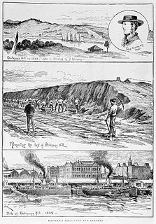
WBatman's Hill in Melbourne, Australia was named for the Vandemonian adventurer and grazier John Batman. Now removed, the 18-metre-high hill was located to the south of today's Collins Street and Southern Cross railway station, and is the site of a steel marker the same height as the original hill.
 W
WPort Phillip is a bay in Victoria, Australia. It has many beaches, most of which are flat, shallow and long, with very small breaks making swimming quite safe. This attracts many tourists, mostly families, to the beaches of Port Phillip during the summer months and school holidays. Water sports such as body boarding and surfing are easy or simple, except in extreme weather conditions.
 W
WBeaumaris Bay is a bay in the east of Port Phillip, Victoria, Australia.
 W
WChinaman's Hat is an octagonal structure serving as a shipping channel marker and haul-out for local brown fur seals, in the South Channel of Port Phillip in the Australian state of Victoria. It is in the Mornington Peninsula Shire, 3 km (1.9 mi) east-south-east of Pope's Eye. Along with the latter it served as a navigation beacon at the Heads of the bay.
 W
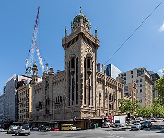
WChinatown is an ethnic enclave in the Central Business District (CBD) of Melbourne, Victoria, Australia. Centred at the eastern end of Little Bourke Street, it extends between the corners of Swanston and Spring Streets, and consists of numerous laneways, alleys and arcades. Established in the 1850s during the Victorian gold rush, it is notable for being the longest continuous Chinese settlement in the Western World and the oldest Chinatown in the Southern Hemisphere.
 W
WMelbourne city centre is the central built up area of the city of Melbourne, Victoria, Australia, centred on the Hoddle Grid, the oldest part of the city laid out in 1837, and includes its fringes. It is not to be confused with the larger local government area of the City of Melbourne which includes this area and the inner suburbs around it.
 W
WThe City Square was a public plaza located in the Central Business District (CBD) of Melbourne, Victoria, Australia. The site is currently bounded by Swanston Street, Collins Street, Flinders Lane and the Westin Hotel. The historic landmarks of Melbourne Town Hall and St Paul’s Cathedral are across the streets to the north and south respectively. The square has been redeveloped several times and associated with a number of controversies over the years.
 W
WThe County of Bourke is one of the 37 counties of Victoria which are part of the Lands administrative divisions of Australia, used for land titles. It is the oldest and most populous county in Victoria and contains the city of Melbourne. Like other counties in Victoria, it is subdivided into parishes. The county was named after Irish born General Sir Richard Bourke, the Governor of New South Wales between 1831 and 1837. It is bordered by the Werribee River in the west, the Great Dividing Range in the north, Port Phillip in the south, and by Dandenong Creek, a small part of the Yarra River, and the Plenty River in the east. The county was proclaimed in 1853.
 W
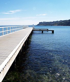
WDaveys Bay is a small shallow bay of Port Phillip, located in Victoria, Australia. It is one of several small bays adjoining the town of Mount Eliza and is the closest region of the Shire of Mornington Peninsula to Melbourne.
 W
WDevilbend Natural Features Reserve is a 1,005 ha park on the Mornington Peninsula 55 km (34 mi) south-east of Melbourne, Australia, between Hastings and Mount Martha in the traditional country of the Bunurong people. It contains two decommissioned water-supply reservoirs, Devilbend and Bittern, which were the original reason the land now in the park was not developed and was protected from general public access.
 W
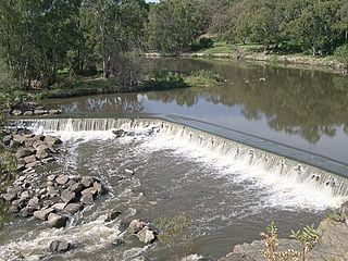
WDights Falls is a rapid and weir on the Yarra River in Melbourne, Victoria, just downstream of the junction with the Merri Creek. At this point the river narrows and is constricted between 800,000-year-old volcanic, basaltic lava flow and a much older steep, silurian, sedimentary spur. The north side also contains abundant graptolite fossils in sedimentary sandstone.
 W
WDocklands is an inner suburb of Melbourne, Victoria, Australia, 2 km (1.2 mi) west of the city's Central Business District (CBD). Its local government area is the City of Melbourne. At the 2016 Census, Docklands had a population of 10,964. Primarily a waterfront area centred on the banks of the Yarra River, it is bounded by Wurundjeri Way and the Charles Grimes Bridge to the east, CityLink to the west and Lorimer Street across the Yarra to the south.
 W
WDoncaster Hill is one of the highest points in the metropolitan area of Melbourne, Australia. Located in the suburb of Doncaster, it is 120 metres above sea level and has uninterrupted views of the city, Port Phillip, Macedon Ranges, the You Yang Ranges and Dandenong Ranges. The hill experienced extensive low-density urban development during the 1960s and 70s, consisting of typical detached suburban dwellings.
WMelbourne city centre is the central built up area of the city of Melbourne, Victoria, Australia, centred on the Hoddle Grid, the oldest part of the city laid out in 1837, and includes its fringes. It is not to be confused with the larger local government area of the City of Melbourne which includes this area and the inner suburbs around it.
 W
WThe East End Theatre District is a precinct within the Melbourne city centre, and is bounded by Spring Street, Flinders Street, Swanston Street, and Lonsdale Street. The district is home to six of Melbourne's major theatres, including the Princess Theatre, Her Majesty's Theatre, and the Regent Theatre. These theatres mostly house commercial productions of musicals, plays and other events, in contrast with the Southbank Arts Precinct over the Yarra River which focuses on publicly funded companies.
WThe Edithvale-Seaford Wetlands are a group of two principally freshwater swamps, totalling 261 hectares, lying in the suburbs of Aspendale, Edithvale, Chelsea Heights, and Seaford in south-eastern Melbourne, Victoria, Australia. Together they form the Edithvale-Seaford Wetlands Ramsar Site. With the nearby Eastern Treatment Plant, they form the Carrum Wetlands Important Bird Area.
 W
WHobsons Bay is a bay in Port Phillip, Victoria, Australia. Hobsons Bay is the northernmost part of Port Phillip. It is adjacent to the Melbourne suburbs of Port Melbourne and Williamstown. The Yarra River flows into Hobsons Bay.
 W
WMelbourne is a city in south-eastern Australia. Most major lakes are used for recreational purposes, mostly sailing, rowing, canoeing and kayaking, but some are used for activities like water skiing or swimming. Melbourne hosts a number of major water catchment reservoirs that supply the city's water as well as many smaller reservoirs or retarding basins used either for water supply or storm water drainage.
 W
WThe Little River is a perennial stream of the Port Phillip & Westernport catchment, located in the Greater Metropolitan Melbourne region of Victoria, Australia. It was also known as Cocoroc Rivulet.
 W
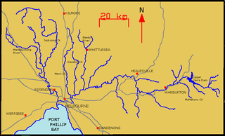
WThe Maroondah Dam is a rock foundation concrete gravity dam with an uncontrolled rock chute spillway across the Watts River, located in the Central region of the Australian state of Victoria. The storage created by the dam is called Maroondah Reservoir. The principal purpose of the dam and its reservoir is to supply potable water for Greater Metropolitan Melbourne.
 W
WThe Melbourne Sandbelt is a region to the southeast of Melbourne Australia known for its sandy soil. Several significant golf courses are located in the region.
 W
WThe Moonee Ponds Creek is a creek and major tributary of the Yarra River running through urban Melbourne, Victoria, Australia from northern to inner suburbs. In 2004 a reporter for the Age newspaper described it as "arguably the most abused tributary of the Yarra River, and part of the true underside of Melbourne".
WThe Mud Islands reserve is located within Port Phillip, about 90 km (56 mi) south-west of Melbourne, Australia, lying 10 km (6.2 mi) inside Port Phillip Heads, 7 km (4.3 mi) north of Portsea and 9 km (5.6 mi) east of Queenscliff. The land area of about 50 hectares is made up of three low-lying islands surrounding a shallow tidal 35-hectare (86-acre) lagoon connected to the sea by three narrow channels. The shapes and configuration of the islands change over the years due to movement of sand by tidal currents.
 W
WPort Phillip , is a horsehead-shaped bay on the central coastline of southern Victoria, Australia, and opens into the Bass Strait through a narrow channel known as The Rip. The bay is surrounded mostly by metropolitan Greater Melbourne in its main eastern portion north of the Mornington Peninsula, and the city of Greater Geelong in the much smaller western portion north of the Bellarine Peninsula. Geographically, the bay covers 1,930 square kilometres and the shore stretches roughly 264 km (164 mi), with the volume of water around 25 cubic kilometres (6.0 cu mi). Most of the bay is navigable, although it is extremely shallow for its size—the deepest portion is only 24 metres (79 ft), and half the bay is shallower than 8 m (26 ft).
 W
WSwanson Dock is an international shipping facility in Melbourne, Victoria, Australia. It was constructed between 1966 and 1972 by the Melbourne Harbour Trust, on the north bank of the Yarra River to alleviate congestion in the port and provide the first container shipping terminal in Melbourne. It is located about 2 km downstream from the Melbourne CBD and was named after Victor Swanson, Chairman of the Melbourne Harbour Trust between 1960 and 1972.
 W
WVictoria Dock is a large excavated harbour basin located off Footscray Road and Docklands Highway, Docklands, in Melbourne. It was constructed between 1887 and 1892, under the supervision of Melbourne Harbour Trust engineer Joseph Brady, to modified designs of British engineer Sir John Coode.
 W
WThe West Melbourne Swamp also known as Batman's Swamp, was a large saltwater wetland located to the west of the city of Melbourne, Victoria. It was drained under the design and supervision of Public Works Department (Victoria) engineer William Thwaites (engineer) from around 1890, and became the site of a canal, the outlet to Moonee Ponds Creek, railway yards and some of Melbourne's docks including Appleton Dock.
 W
WThe Yarra River is a river in southern Victoria, Australia; which flows through the city of Melbourne. Over the river's 242-kilometre (150 mi) length there are many structures that bridge the river.
WThe Yarra River is a river in East-Central Victoria, Australia that flows through the city of Melbourne. This article contains explanations and lists of the river's tributaries and other geographic features. The river flows atop layers of silt that built up within an ancient river valley around 10,000-15,000 years ago.