 W
WThe history of geography includes many histories of geography which have differed over time and between different cultural and political groups. In more recent developments, geography has become a distinct academic discipline. 'Geography' derives from the Greek γεωγραφία – geographia, literally "Earth-writing", that is, description or writing about the Earth. The first person to use the word geographia was Eratosthenes. However, there is evidence for recognizable practices of geography, such as cartography (map-making), prior to the use of the term.
 W
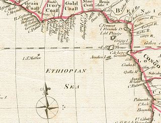
WAethiopian, Æthiopian, Æthiopic or Ethiopian Sea or Ocean was the name given to the southern half of the Atlantic Ocean in classical geographical works. The name appeared in maps from ancient times up to the turn of the 19th century.
 W
WThe Age of Sail was a period roughly corresponding to the early modern period in which international trade and naval warfare were dominated by sailing ships and gunpowder warfare, lasting from the mid-16th to the mid-19th centuries.
 W
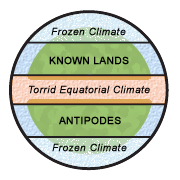
WAntichthones, in geography, are those peoples who inhabit the antipodes, regions on opposite sides of the Earth. The word is compounded of the Greek ὰντὶ ("opposed") and χθών ("earth").
 W
WThe Atlantic World comprises the interactions among the peoples and empires bordering the Atlantic Ocean rim from the beginning of the Age of Discovery to the early 21st century. Atlantic history is split between three different contexts: trans-Atlantic history, meaning the international history of the Atlantic World; circum-Atlantic history, meaning the transnational history of the Atlantic World; and cis-Atlantic history within an Atlantic context. The Atlantic slave trade continued into the 19th century, but the international trade was largely outlawed in 1807 by Britain. Slavery ended in 1865 in the United States and in the 1880s in Brazil (1888) and Cuba (1886). While some scholars stress that the history of the "Atlantic World" culminates in the "Atlantic Revolutions" of the late 18th early 19th centuries, the most influential research in the field examines the slave trade and the study of slavery, thus in the late-19th century terminus as part of the transition from Atlantic history to globalization seems most appropriate.
 W
WThe Bedford Level experiment is a series of observations carried out along a 6-mile (9.7 km) length of the Old Bedford River on the Bedford Level of the Cambridgeshire Fens in the United Kingdom, during the 19th and early 20th centuries, to measure the curvature of the Earth. Samuel Birley Rowbotham, who conducted the first observations starting in 1838, claimed that he had proven the Earth to be flat. However, in 1870, after adjusting Rowbotham's method to avoid the effects of atmospheric refraction, Alfred Russel Wallace found a curvature consistent with a spherical Earth.
 W
WThe study of geography in China begins in the Warring States period. It expands its scope beyond the Chinese homeland with the growth of the Chinese Empire under the Han dynasty. It enters its golden age with the invention of the compass in the 11th century and peaks with 15th century Chinese exploration of the Pacific under admiral Zheng He during the treasure voyages.
 W
WChorography is the art of describing or mapping a region or district, and by extension such a description or map. This term derives from the writings of the ancient geographer Pomponius Mela and Ptolemy, where it meant the geographical description of regions. However, its resonances of meaning have varied at different times. Richard Helgerson states that "chorography defines itself by opposition to chronicle. It is the genre devoted to place, and chronicle is the genre devoted to time". Darrell Rohl prefers a broad definition of "the representation of space or place".
 W
WFrederick Albert Cook was an American explorer, physician, and ethnographer who claimed to have reached the North Pole on April 21, 1908. That was nearly a year before Robert Peary, who similarly claimed to have reached the North Pole on April 6, 1909. Both men's accounts have been disputed ever since. His expedition discovered Meighen Island, the only discovery of an island in the North American Arctic by an expedition with a United States national on board.
WCritical geography is theoretically informed geographical scholarship that seeks for social justice, liberation, and leftist politics. Critical geography is also used as an umbrella term for Marxist, feminist, postmodern, poststructural, queer, left-wing, and activist geography.
 W
WThis article covers the science, art and industry of cartography by the people of the Low Countries in the early modern period, especially in the early 16th to early 18th centuries. It includes cartography of the Northern Netherlands, Southern Netherlands and Low Countries in general. It also includes Dutch colonial cartography, i.e. cartography in the Dutch overseas world, in the early modern period.
WEnvironmental determinism is the study of how the physical environment predisposes societies and states towards particular development trajectories. Many scholars underscore that this approach supported colonialism and eurocentrism, and devalued human agency in non-Western societies. Jared Diamond, Jeffrey Herbst, Ian Morris, and other social scientists sparked a revival of the theory during the late twentieth and early twenty-first centuries. This "neo-environmental determinism" school of thought examines how geographic and ecological forces influence state-building, economic development, and institutions.
 W
WThe Erythraean Sea was a former maritime designation that always included the Gulf of Aden and at times other seas between Arabia Felix and the Horn of Africa. Originally an ancient Greek geography, it was used throughout Europe until the 18-19th century. At times the name frequently extended beyond the Gulf of Aden—as in the famous 1st-century Periplus of the Erythraean Sea—to include the present-day Red Sea, Persian Gulf, and Indian Ocean as a single maritime area.
 W
WThe era of European and American voyages of scientific exploration followed the Age of Discovery and were inspired by a new confidence in science and reason that arose in the Age of Enlightenment. Maritime expeditions in the Age of Discovery were a means of expanding colonial empires, establishing new trade routes and extending diplomatic and trade relations to new territories, but with the Enlightenment scientific curiosity became a new motive for exploration to add to the commercial and political ambitions of the past. See also List of Arctic expeditions and List of Antarctic expeditions.
 W
WThe exploration of North America by non-indigenous people was a continuing effort to map and explore the continent and advance the economic interests of said non-indigenous peoples of North America. It spanned centuries, and consisted of efforts by numerous people and expeditions from various foreign countries to map the continent. See also the European colonization of the Americas
 W
WFarther India, or Ultraindia, is an old term, now rarely used, for Southeast Asia, seen in colonial days from Europe as the part of the Far East beyond the Indian subcontinent, but south of China.
 W
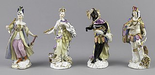
WEuropeans in the 16th century divided the world into four continents: Africa, America, Asia and Europe. Each of the four continents was seen to represent its quadrant of the world—Europe in the north, Asia in the east, Africa in the south, and America in the west. This division fit the Renaissance sensibilities of the time, which also divided the world into four seasons, four classical elements, four cardinal directions, four classical virtues, etc.
 W
WThe Geography, also known by its Latin names as the Geographia and the Cosmographia, is a gazetteer, an atlas, and a treatise on cartography, compiling the geographical knowledge of the 2nd-century Roman Empire. Originally written by Claudius Ptolemy in Greek at Alexandria around AD 150, the work was a revision of a now-lost atlas by Marinus of Tyre using additional Roman and Persian gazetteers and new principles. Its translation into Arabic in the 9th century and Latin in 1406 was highly influential on the geographical knowledge and cartographic traditions of the medieval Caliphate and Renaissance Europe.
 W
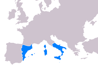
WCartography throughout the 14th-16th centuries played a significant role in the expansion of the kingdoms of the Iberian Peninsula for a multitude of reasons. Primarily, the maps developed during this period served as navigational tools for maritime folk such as explorers, sailors and navigators. Mostly the expansion of the Crown of Aragon (which included the Kingdom of Aragon, Kingdom of Valencia and Kingdom of Majorca, together with the Principality of Catalonia, all its territories with seashore on the Mediterranean Sea. The Crown of Aragon controlled the routes across the Mediterranean Sea from the Kingdom of Jerusalem to Europe, as part of the commercial-trade route known as the Silk Road.
 W
W W
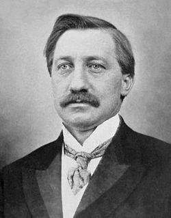
WVictor Adolphe Malte-Brun was a French geographer and cartographer.
 W
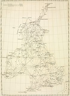
WThe Principal Triangulation of Britain was the first high-precision trigonometric survey of the whole of Great Britain, carried out between 1791 and 1853 under the auspices of the Board of Ordnance. The aim of the survey was to establish precise geographical coordinates of almost 300 significant landmarks which could be used as the fixed points of local topographic surveys from which maps could be drawn. In addition there was a purely scientific aim in providing precise data for geodetic calculations such as the determination of the length of meridian arcs and the figure of the Earth. Such a survey had been proposed by William Roy (1726–1790) on his completion of the Anglo-French Survey but it was only after his death that the Board of Ordnance initiated the trigonometric survey, motivated by military considerations in a time of a threatened French invasion. Most of the work was carried out under the direction of Isaac Dalby, William Mudge and Thomas Frederick Colby, but the final synthesis and report (1858) was the work of Alexander Ross Clarke. The survey stood the test of time for a century, until the Retriangulation of Great Britain between 1935 and 1962.
WThe quantitative revolution (QR)[n] was a paradigm shift that sought to develop a more rigorous and systematic methodology for the discipline of geography. It came as a response to the inadequacy of regional geography to explain general spatial dynamics. The main claim for the quantitative revolution is that it led to a shift from a descriptive (idiographic) geography to an empirical law-making (nomothetic) geography. The quantitative revolution occurred during the 1950s and 1960s and marked a rapid change in the method behind geographical research, from regional geography into a spatial science.
 W
WThe Ravenna Cosmography is a list of place-names covering the world from India to Ireland, compiled by an anonymous cleric in Ravenna around AD 700. Textual evidence indicates that the author frequently used maps as his source.
WRegional geography is a major branch of geography. It focuses on the interaction of different cultural and natural geofactors in a specific land or landscape, while its counterpart, systematic geography, concentrates on a specific geofactor at the global level.
The Russian Geographical Society (RGO) is a learned society based in Saint Petersburg, Russia. It promotes exploration and geography with research programs in fields including oceanography and ethnography.
 W
WThe Sea of Zanj is a former name for that portion of the western Indian Ocean adjacent to the region in the African Great Lakes referred to by medieval Arab geographers as Zanj. The Sea of Zanj was deemed a fearful zone by Arab mariners and legends regarding dangers in the waters abounded, especially near its far southern limits.
 W
WThe Société de Géographie, is the world's oldest geographical society. It was founded in 1821 as the first Geographic Society. Since 1878, its headquarters have been at 184 Boulevard Saint-Germain, Paris. The entrance is marked by two gigantic caryatids representing Land and Sea. It was here, in 1879, that the construction of the Panama Canal was decided.
 W
WThis timeline of European exploration lists major geographic discoveries and other firsts credited to or involving Europeans during the Age of Discovery and the following centuries, between the years AD 1418 and 1957.
 W
WThe humanist and theologian Jacob Ziegler of Landau in Bavaria, was an itinerant scholar of geography and cartographer, who lived a wandering life in Europe. He studied at the University of Ingolstadt, then spent some time at the court of Pope Leo X before he converted to Protestantism; subsequently his geographical works were placed on the Index Librorum Prohibitorum.