 W
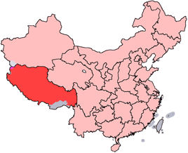
WThis is an alphabetical list of all populated places, including cities, towns and villages, in the Tibet Autonomous Region of western China.
 W
WKangsa Village, poetically known as Darchen, Tarchan or Taqin, is a former Bhutanese enclave, currently held by the People's Republic of China and the seat of the Parga Township, Purang County, Tibet Autonomous Region, China. Thus, it's commonly referred as Parga although there is another smaller settlement formally named Parga after which the Parga Township was named, located on the east of this settlement. It was also previously known as Lhara and still signposted as such. It was previously an important sheep station for nomads and their flocks and had only two permanent buildings; only one of which survived the Cultural Revolution and is now used to house Tibetan pilgrims.
 W
WDêlêg is a village in Xaitongmoin county of Shigatse Prefecture in the Tibet Autonomous Region of China, northeast of the county seat. The Tibetan name means "good luck". It lies at an elevation of 4,804 metres. In 2007 the village had a population of about 350.
WDongqiao is a village in Amdo County of Nagqu Prefecture, Tibet Autonomous Region, People's Republic of China. The village of Dongqiao is noted for its hot spring, Jipu. Dongqiao geologically gives its name to the wider Dongqiao-Nagqu Subregion and the Banggong-Dongqiao-Nujiang fault zone.
 W
WGar Chongsar or Gar Xincun, Gar New Village, is a village in Gar County, Ngari Prefecture, Tibet Autonomous Region, China. It is the site of the Ngari Gunsa Airport.
WGartok, now called Garyarsa, is a trade-market of Tibet, situated on the bank of the Indus on the road between Shigatse and Leh, to the east of Simla. At an elevation of 14,630 ft, it is located at the base of the Kailash Range; it was formerly the main town and summer capital of western Tibet, and its administrator was called the Garpön. The name means 'military camp.' Pop. fewer than 10,000.
WGolag is a township in the northeast of Zayü County, Nyingchi, in the southeast of the Tibet Autonomous Region.
 W
WGolmud, also known by various other romanizations, is a county-level city in the Haixi Mongol and Tibetan Autonomous Prefecture of Qinghai Province, China. It is now the second-largest city in Qinghai and the third largest in the Tibetan Plateau. The population is now about 205,700.
WGünsa Township, or Kunsa, is a township consisting of three villages in Gar County in the Ngari Prefecture of the Tibet Autonomous Region of China. Near the village of Sogmai and Gar Chongsar is the site of Ngari Gunsa Airport.
 W
WKangmar Town is a town in the Kangmar County of the Shigatse Prefecture in the Tibet Autonomous Region of the China, at an elevation of 5,358 m (17,581 ft). It lies very close to the border with Bhutan.
 W
WKhamber Jong, also called Gamba, Kampa, or Khampa Dzong, is a Tibetan hamlet north of Sikkim. In June 1903, Colonel Francis Younghusband, serving as British commissioner to Tibet, led a diplomatic mission consisting of five officers and five hundred troops through Nathu La to Khamber Jong. The objective of the mission was to meet Chinese and Tibetan representatives and discuss mutual non-aggression and trade agreements. After being kept waiting for five months before the Chinese and Tibetan representatives arrived, the mission was recalled.
 W
WLhasa is the urban center of the prefecture-level Lhasa City and the administrative capital of the Tibet Autonomous Region. The inner urban area of Lhasa City is equivalent to the administrative borders of Chengguan District, which is part of the wider prefectural Lhasa City.
WLhasa is a prefecture-level city, one of the main administrative divisions of the Tibet Autonomous Region of China. It covers an area of 29,274 square kilometres (11,303 sq mi) of rugged and sparsely populated terrain. Its capital and largest city is Lhasa, with around 300,000 residents, which mostly corresponds with the administrative Chengguan District, while its suburbs extend into Doilungdêqên District and Dagzê District. The consolidated prefecture-level city contains additional five, mostly rural, counties.
 W
WMêdog, Metok, or Motuo County Mêdog is a town in the Tibet Autonomous Region of China. Medog town is the seat of Mêdog County, within the administration of Nyingchi Prefecture, Formally called Metok Dzong, it used to be the residence of Dzongpon representing the authority of Tibetan Lhasa Govt. Metok town is located within the valley of the great bend of river Tsangpo (Brahmaputra), its elevation is the lowest of all the counties of Tibet hence the town is abundant in vegetation and has rich flora and fauna. Metok is in the heart of Pema ko which connects the county with rest of the country. Majority of Metok population is pemakopas, with significant minority of khampas, kongpopas and Lhopa.
 W
WNêdong or Nêtong is a village in Nêdong County, in the Shannan Prefecture of Tibet.
WNyingzhong Township, or Ningzhong Township is a township of Damxung County, Tibet Autonomous Region, China located 21 kilometres (13 mi) southwest of the county seat and 82 km (51 mi) north-northwest of Lhasa. Road access to both the aforementioned places is provided by China National Highway 109. As of 2011, it has 4 villages under its administration.
WPei is a town in Mainling County, Tibet Autonomous Region. The town is situated on the only road from Mainling to Mêdog, near the entrance to the Yarlung Tsangpo Grand Canyon. The population was 1,771 (2000).
WRisong Township is a township of Rutog County, in far western Tibet Autonomous Region, People's Republic of China, located 28 kilometres (17 mi) south of Pangong Tso, a large lake, and 81 km (50 mi) north of the seat of Ngari Prefecture. As of 2011, it has 3 villages under its administration. It is directly serviced by China National Highway 219.
 W
WRudok is a small town on the Ladakh frontier of Tibet. Rudok is picturesquely situated on the side of a hill standing isolated in the plain near the east end of Lake Pangong in Ladakh. Historically an integral part of Ladakh, it is also greographically and culturally a part of Ladakh. The houses are built in tiers, whitewashed and walled in. At the top of the hill are a large palace and several monasteries painted red. About a mile away from the foot of the hill is another monastery. Rudok is about 13,300 feet above sea-level, and the greatest altitude on the route connecting it with Lhasa at the pass of Mariom la is 15,500 feet. The winter climate of Rudok and of all the towns of the Tsangpo basin, owing to the intense dryness of the air and the light fall of snow, seems to be bracing and exhilarating rather than severe. The thermometer never approaches the minimum record of Puetra, according to the observations of native surveyors. The modern spelling is Rutog.
 W
WSamzhubzê District is a district in the Tibet Autonomous Region of the China, and the administrative center of the prefecture-level city of Shigatse. Prior to 2014 it was known as the county-level city of Shigatse. It was the ancient capital of Ü-Tsang province and is the second largest city in Tibet with an estimated population of 117,000 in 2013. Samzhubzê is located at the confluence of the Yarlung Tsangpo River and the Nyang River, about 250 km (160 mi) southwest of Lhasa and 90 km (56 mi) northwest of Gyantse, at an altitude of 3,840 metres (12,600 ft).
WShangzayü is a town of Zayü County, in southeastern Tibet Autonomous Region, People's Republic of China (PRC), located in a deep river valley 68 km (42 mi) from the county seat and bordering India's Arunachal Pradesh, which is claimed by the PRC, to the south and west. As of 2003, it has a population of 3002, and as of 2011, it has 16 villages under its administration.
 W
WShiquanhe, traditionally known as Sênggêkanbab or Sênggêzangbo, is the main town and administrative seat of Ngari Prefecture, Tibet Autonomous Region, China. Shiquanhe is located on the confluence of Sênggê Zangbo and Gar River.
WSogmai, or Suomai is a village in Günsa Township, Gar County, Tibet Autonomous Region, China. It is the site of the Ngari Gunsa Airport.
 W
WGangga is a town in Tingri County, in the south of the Tibet Autonomous Region. It has a population of around 523, and is often used as a base by mountain climbers preparing to ascend Mount Everest or Cho Oyu. It is known for its views of Mount Everest, Mount Lhotse, Mount Makalu, and Cho Oyu, which comprise four of the six highest mountains in the world.
 W
WTsetang, is once the fourth largest city in Tibet and is located in the Yarlung Valley, 183 km (114 mi) southeast of Lhasa in Nêdong District of Shannan, Tibet Autonomous Region of China. As capital of Shannan City, it "...exercises direct control over the affairs of 13 counties: Gongkar, Tranang, Nedong, Changye, Tso-me, Lhodrok, Nakartse, Zangri, Chutsum, Lhuntse, Tsona, Gyatsa and Nang."
WXiazayü is a town of Zayü County, in southeastern Tibet Autonomous Region, People's Republic of China (PRC), located in a deep river valley 47 km (29 mi) from the county seat and bordering India's Arunachal Pradesh, which is claimed by the PRC, to the southwest, as well as Burma to the southeast. As of 2005, it has a population of 5389 residing in an area of 1,215.07 km2 (469.14 sq mi), and as of 2011, it has 18 villages under its administration. The town contains a population of the Mishmi people, which has yet to be officially recognised as one of the PRC's 56 ethnicities. Tourism was developing in the Shaqiong Deng Village (沙瓊僜人村). However, foreigners were not allowed to enter Zayü as of 2011.
WXiongmei is a town of Xainza County, in central Tibet Autonomous Region, China, located about 20 km (12 mi) south of Siling Lake. As of 2011, it has 10 villages under its administration.
WYanhu Township is a township in the east of Gê'gyai County, western Tibet Autonomous Region, People's Republic of China.
 W
WThe Yarlung Valley is formed by the Yarlung Tsangpo River and refers especially to the district where it joins with the Chongye River, and broadens out into a large plain about 2 km wide, before they flow north into the Yarlung Tsangpo River or Brahmaputra. It is situated in Nedong County of Lhokha Prefecture in the Tibet Autonomous Region of China. The capital of Lhokha Prefecture, Zêtang, in the Yarlung Valley, is one of Tibet's largest cities, and is 183 km southeast of Lhasa.
 W
WZhol Village or Shol Village was a small village at the base of the Potala Palace in Lhasa, Tibet.