 W
WThe Albanian Adriatic Sea Coast stretches in the Southeastern Adriatic Sea beginning at the Gulf of Drin in the north, across the port cities of Shëngjin, Durrës and Vlorë, to the Bay of Vlorë in the south, where the Albanian Riviera as well as the Albanian Ionian Sea Coast begins.
 W
WThe Albanian Ionian Sea Coast is a coastline of the Northeastern Ionian Sea, that encompasses the southwestern border of the Republic of Albania, stretching from the southern half of Karaburun Peninsula, across the historical region of Labëria, the city of Sarandë, the mountains of the Ceraunians and the Albanian Riviera, to the Lake of Butrint, where the Strait of Corfu separates the country from Greece.
 W
WThe Albanian Ohrid Lake Coast is a coastline of the Western Ohrid Lake, that encompasses the southeastern border of the Republic of Albania, stretching from the north of the Bay of Lin nearby the northern border shared with the Republic of Macedonia, across the villages of Memëlisht, Buqezë, Piskupat and the city of Pogradec, to the southern border shared with Macedonia as well.
 W
WAli Pasha Castle is a castle in Albania. It is named after Ali Pasha of Tepelenë who resided there until 1820. The current fortress was rebuilt in 1819 from its surface with 3 towers. Until 1820 it was the second residence of Ali Pashe Tepelena.
 W
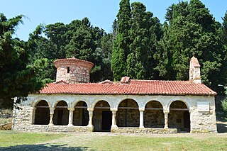
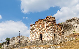
WThe Holy Trinity Church is a medieval Byzantine church which stands on a hill in the city of Berat in the Kalaja district of Southern Albania.
 W
WBogovë Nature Park is a nature park in southern Albania, spanning an area of 3.3 km2 (1.3 sq mi). It was established in 1977 to protect several ecosystems and biodiversity of national importance. The nature park of Bogovë falls inside the Pindus Mountains mixed forests terrestrial ecoregion of the Palearctic Mediterranean forests, woodlands, and scrub biome.
 W
WThe Buna River Velipoje Protected Landscape is a protected landscape area in northwestern Albania, encompassing the estuary of Drin, the lagoon of Viluni, the river of Buna with its estuary, and the gulf of Drin that runs across the city of Velipojë alongside the Adriatic Sea.
 W
WThe Butrint National Park is a national park in southern Albania, located 18 kilometres (11 mi) south of Sarandë in Vlorë County. The park encompasses 9,424 hectares (94.24 km2) of hilly terrain with freshwater lakes, wetlands, salt marshes, open plains, reed beds and islands. The park's significance for conservation is reflected in the large number of species with over 1,200 different animals and plants. Its mandate includes the protection of the lake and lagoon of Butrint, the natural channel of Vivari, the islands of Ksamil and as well the archaeological site, that provides valuable remains of ancient civilisations.
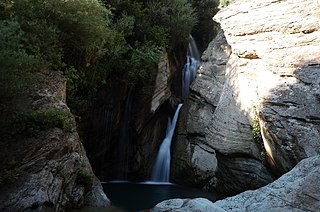
WThe Canyon of Gjipe is a bay and calcareous canyon located between Dhërmi and Vuno carved by the Ionian Sea in Vlorë County, Albania. The canyon occupies a length of 800 metres (2,600 ft) and a width that can varies between 10 metres (33 ft) and 20 metres (66 ft). It represents a narrow strait, created by the activity of the brook flowing through its narrow pass. There are numerous rock formations along the canyon, including a number of caves.
 W
WThe Fir of Hotovë-Dangelli National Park is the largest national park in Albania located in Gjirokastër County with a surface area of 34,361 ha (343.61 km2). The park takes its name from the Hotova Fir, which is considered one of the most important Mediterranean plant relics of the country. Although, it encompasses of hilly and mountainous terrain composed of limestone and sandstone deposits, with numerous valleys, canyons, gorges, rivers and dense deciduous and coniferous forests. The International Union for Conservation of Nature (IUCN) has listed the park as Category II. The park also includes 11 natural monuments.
 W
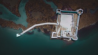
WThe Fortress of Bashtovë is a medieval quadrangular fortress located close to the outflow of the Shkumbin River into the Adriatic Sea in Central Albania. It is part of the tentative list of Albania in order to qualify for inclusion in the UNESCO World Heritage Site list.
 W
WThe Gashi is a 27-kilometre-long (17 mi) river located in Tropojë, northern Albania. It is a nature reserve, spanning an area of 3,000 ha. The nature reserve forms a part of the European Green Belt and has been declared a UNESCO World Heritage Site within the Primeval Beech Forests of the Carpathians and Other Regions of Europe.
 W
WGuri i Nikës Resource Reserve is a protected area in southeastern Albania, spanning an area of 22 km2 (8.5 sq mi). It was established in 1996 to protect several ecosystems and biodiversity of national importance. The resource reserve of Guri i Nikës falls inside the Pindus Mountains mixed forests terrestrial ecoregion of the Palearctic Mediterranean forests, woodlands, and scrub biome. A number of different species such as the brown bear and gray wolf, that are fast becoming rare in Southern Europe, reside in the region.
 W
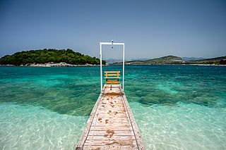
WThe Islets of Ksamil, consist of four rocky islets located in the direct proximity to the Ionian Sea in Southern Albania. The village of Ksamil, after whom the islets are named, is located to the east of the islets. Furthermore, the islands are situated within the boundaries of the Butrint National Park.
WThe Karaburun-Sazan Marine Park is a marine park in the Vlorë County of southwestern Albania. The marine park encompasses over 125.70 km2 (48.53 sq mi) and comprises the boundaries of both the Peninsula of Karaburun and the Island of Sazan. It is home to a vast array of landforms, including mountains, caves, islands, depressions, bays, cliffs, canyons and rocky coasts, all contributing to an exceptionally considerable biological diversity. The marine park has been identified as an Important Bird and Plant Area, because it supports immense bird and plant species. Containing ecosystems and habitats that are specific to the Mediterranean Basin, the convention of Barcelona has classified the marine park as a Specially Protected Areas of Mediterranean Importance.
 W
WThe Korab-Koritnik Nature Park is a nature park in eastern Albania and forms a section of the European Green Belt, which serves as a retreat for endangered animal and plant species. It encompasses 55,550 hectares (555.5 km2) of alpine mountainous terrain, with valleys, rivers, glacial lakes, caves, canyons, dense coniferous and deciduous forest. The International Union for Conservation of Nature (IUCN) has listed the park as Category IV. Both, Koritnik and Korab has been recognised as an Important Plant Area of international importance by Plantlife.
 W
WThe Kune-Vain-Tale Nature Reserve is a nature park located within the Lezhë County forming the Drin river delta and facing the Adriatic Sea in northern Albania. It spans an area of 43.93 km2 (16.96 sq mi). The nature reserve was established in 2010, it encompasses the Kunë Island, the Kunë-Vain lagoon, the woodlands, and several ecosystems. Notably, it has been also identified as an Important Bird Area by BirdLife International.
WThe Lake Shkodër Nature Reserve is a nature reserve in northwestern Albania.
WThe Llogara National Park is a national park centered on the Ceraunian Mountains along the Albanian Riviera in Southwestern Albania, spanning an surface area of 1,010 ha (10.1 km2). The park's terrain includes large alpine meadows, vertical rock faces, precipices and dense forests. The most area of land is covered by forests and was established in 1966 to protect several ecosystems and biodiversity of national importance. The International Union for Conservation of Nature (IUCN) has listed the park as Category II. The region has been recognised as an important Bird and Plant Area, because it support significant numbers of various bird and plant species.
 W
WThe Lurë-Dejës Mt National Park is a national park in northeastern Albania, spanning an expanded area of 202.42 km2 (78.15 sq mi) since 2018 by encompassing the entire section of Kunora e Lurës, former Zall-Gjocaj National Park, and Dejë Mountain. The park was originally established in 1966 to protect the various ecosystems and biodiversity as Lura National Park. The altitude vary from 1,500–2,300 m (4,921–7,546 ft). The International Union for Conservation of Nature (IUCN) has listed the park as Category II. Nevertheless, it is described as an important Bird and Plant Area, because it supports significant bird and plant species.
 W
WThe Nikaj-Mërtur Regional Nature Park is a regional nature park in northern Albania, strategically inside the southeastern Albanian Alps in Tropojë. It lies within the area of the historical Nikaj-Mërturi region. The park is an area of alpine landscapes, deep valleys, vertical cliffs, dense coniferous and deciduous forests, small lakes and rivers. The International Union for Conservation of Nature (IUCN) has listed the park as Category IV. Like most of the Albanian Alps, it is listed as an important Plant Area, because it supports significant plant species.
 W
WThe Porto Palermo is a bay in southwestern Albania.
WThe Shebenik-Jabllanicë National Park is a national park in eastern Albania adjacent to the border with North Macedonia. It encompasses 339.277 square kilometres (33,927.7 ha) and is specifically marked by a mountainous landscape supplied with glacial lakes, valleys, dense coniferous and deciduous forests and alpine meadows and pastures. Elevations in the park vary from 300 metres to over 2,200 metres above the Adriatic at the peak of Shebenik and Jabllanica, hence the name. It dwells a number of endangered species that are fast becoming rare in Southern Europe, including the brown bear, gray wolf and balkan lynx. The abundance in wildlife can in part be explained by the variety of vegetation types and remote location.
 W
WThe St. Mary's Monastery, also known as the Monastery of Dormition of Theotokos Mary, is a medieval Byzantine church in Zvërnec Island inside the Narta Lagoon northwest of the city of Vlorë of Southern Albania.
 W
WThe St. Michael's Church is a medieval Byzantine church outside the Kalaja district on a hilltop of the city of Berat of Southern Albania. As part of the Historic Centres of Berat and Gjirokastër UNESCO World Heritage Site, the church was possibly constructed in the fourteenth century and is dedicated to the Christian archangel of Michael.
 W
WThe Theth National Park is a national park in northern Albania. Established in 1966, the park covers 2,630 ha (26.3 km2) and is centred on the Albanian Alps, encompassing the larger portion of Shala Valley. The park was established to protect various ecosystems and biodiversity and the cultural and historical heritage of the region. It is dominated by high terrain, with a wide variety of natural features including valleys, rivers, mountains, waterfalls, dense forests and several rock formations. The International Union for Conservation of Nature (IUCN) has listed the park as Category II. Notably, the region has been also identified as an important Bird and Plant Area. In 2017, Theth has been further declared a Protected Historic Center.
WThe Tomorr National Park is a national park founded in 1956 that lies in southern Albania, nestled in the central and higher portions of the Tomorr massif, spanning an area of 261.06 km2 (100.80 sq mi) since 2012, and expanded to include its quarry areas since 2019. The park covers a territory of 26,106 ha. The area falls within the Berat County and only 1,278 ha inside the Elbasan County. The park was established in 1956 and is considered one of the most important protected areas for the maintenance of mountainous biodiversity and ecosystem integrity at the national level. The park has been recognised as an Important Plant Area of international importance by Plantlife.
 W
WThe tourist attractions in Berat refers to the tourist attractions in Berat. The city of Berat is a city in the south of the Republic of Albania and the capital of the surrounding Berat County. It offers a variety of tourist attractions, including historical sights, monuments, museums, theatres, churches, monasteries, mosques and places.
 W
WThe Valbona Valley National Park is a national park inside the Albanian Alps in northern Albania. The park covers a total area of 80 km2 (31 sq mi), encompassing Valbona River and its surrounding areas with mountainous terrain, alpine landscapes, glacial springs, deep depressions, various rock formations, waterfalls and the Valbona Valley with its dense coniferous and deciduous forest. It is characterized by its very remote areas which have a large preserved ecosystem all of which is primarily untouched with pristine quality. This vast pristine ecosystem is the centrepiece of what has been referred to as the Albanian Miracle of the Alps.
 W
WThe Vjosa-Narta Protected Landscape is a protected landscape area in southwestern Albania. It covers a total area of 194.12 square kilometres (74.95 sq mi), encompassing the lagoon of Narta along with the estuary of the Vjosë and its surrounding areas dotted with freshwater wetlands, marshlands, reed beds, woodlands, islands and sandy beaches. The International Union for Conservation of Nature (IUCN) has listed the park as Category VI. It is also listed as an important Bird and Plant Area, because it supports significant bird and plant species.