 W
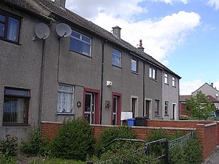
WArdler is an area in the north-west of Dundee, Scotland, built on land previously owned by Downfield Golf Club. The housing scheme was completed in the late 1960s and originally included six 17-storey multi-storey blocks that formed the northern part of the scheme. These were demolished between 1993 and 2007 as part of a major programme of regeneration due to finish in 2011.
WBalgay is a suburb in the west end of Dundee, Scotland. The name, derived from Gaelic, seems to mean 'stead of the marsh/wind' . During the 17th century, Balgay House was built and now this has become incorporated into Royal Victoria Hospital. Balgay Hill and Victoria Park were acquired by Dundee City Corporation in 1870 as public parks. The Mills Observatory designed by James MacLellan Brown was added in 1935 at the summit of the 143m hill. It is the only full-time public observatory in UK.
WBalgillo is a housing development in the Dundee suburb of Broughty Ferry. It is bounded by Balgillo Road to the south, the A92 Dundee to Arbroath dual carriageway to the north, Balgillo Road East to the west, and Panmurefield Village to the east.
WBalgowan is an area of Dundee, Scotland. The name derives from the Scottish Gaelic Baile Ghobhainn, meaning "blacksmith's stead".
 W
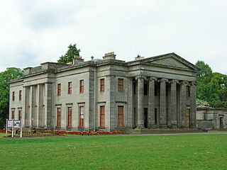
WBallumbie is a residential area on the north-east edge of Dundee, Scotland. The area was formerly an estate centred on Ballumbie Castle, a mid-16th-century fortification, which was followed by the 19th-century Ballumbie House. There is also a golf course surrounded by a medieval wall and the site of a late medieval parish church. The castle and house are located just outside the City of Dundee, in Angus.
WBarnhill is an area in Dundee, located within the suburb of Broughty Ferry. It is approximately 4½ miles east of Dundee City Centre. Until the late 19th century, Barnhill was a separate village.
 W
WBlackness is an area of the city of Dundee. Broadly, Blackness is located to the north of the city's West End and is centred on the Blackness Road, where a number of small, local shops are located. The presence of the Scouring Burn meant that the area was attractive for industrial development in the late eighteenth and early nineteenth centuries, modern steam powered machinery requiring a substantial water supply.
WBroughty Ferry is a suburb of Dundee, Scotland. It is situated four miles east of the city centre on the north bank of the Firth of Tay. The area was a separate burgh from 1864 until 1913, when it was incorporated into Dundee.
 W
WCamperdown is an area of Dundee, Scotland, best known for Camperdown Park, which is the largest park in the city.
WCharleston is an area on the northwest edge of Dundee, Scotland. Menzieshill is to the immediate southwest, Camperdown borders it to the north, and Lochee is to the east.
WUntil the industrial revolution the current City Centre represented the full extent of the City of Dundee, Scotland. Now roughly encircled by the Marketgait dual carriageway, the city centre is now the main shopping and commercial district. Unlike the city centre of Glasgow many of the city centre's streets are not built on a grid plan and in that way have more in common with street plan of the Old Town of Edinburgh.
 W
WClaverhouse is a residential area located on the northern outskirts of Dundee, Scotland with the city centre located 2 miles (3.2 km) from the area.
WCraigiebank is an area of eastern Dundee, Scotland. It borders three other areas of the city: West Ferry to the east, Pitkerro to the north, Baxter Park and East Port to the south-west.
WDouglas and Angus is an area of Eastern Dundee, Scotland. It is located between Whitfield to the North and Broughty Ferry to the East.
WDownfield is a residential area located in the north of Dundee, Scotland, centred on the stretch of the Strathmartine Road between the Kingsway and the northern boundary of Dundee. The area is bordered by St Marys and Ardler to the west, Kirkton to the east and Fairmuir to the south.
 W
WDryburgh is the name of a district of Dundee, Scotland, home to The View. The band featured locations throughout the area in their video for their 2006 track Superstar Tradesman. The Dryburgh estate has been used for the band's 2007 videos for Skag Trendy and The Don. These videos also feature areas of Lochee near Dryburgh, in particular 'Davies' cafe in Lochee high street.
 W
WFintry is a housing scheme in Dundee, Scotland. Fintry is located in the north of the city with Mill o' Mains to the west and Whitfield to the east. On the north, Fintry is bordered by farmland, including the Powrie Farm and Powrie Castle. Local parks include Powrie Park and Finlathen Park. Fintry has a population of 6592.
WGowrie Park is a residential area of Dundee, Scotland, United Kingdom. Sandwiched between Menzieshill and Dundee Technology Park, it is located in the western edge of the city. The Gowrie Park suburb was developed by local builders Bett Brothers in the 1970 and 80s and all homes are all privately owned. The streets all have names from places in the western Highlands of Scotland.Applecross Gardens Arisaig Gardens Canisp Crescent Dornie Place Durness Terrace Greenstone Place Greenstone Terrace Ledmore Terrace Lochinver Crescent Mallaig Avenue Peterburn Terrace Rosehall Gardens Strathaird Place Ullapool Crescent
 W
WHilltown in Dundee, Scotland, is a mainly residential area to the north of the City Centre and lying to the south of the main circular road.
WKirkton is a residential housing scheme located in the north of Dundee. The area is bordered by Downfield to the west, Trottick to the east and Fairmuir to the south.
 W
WThe Dundee Law is a hill in the centre of Dundee, Scotland. The Law is what remains of a volcanic sill and it is the highest point in the centre of Dundee. With a large war memorial at its summit, it is the most prominent feature on the local skyline.
WLochee is an area in the west of Dundee, Scotland. Until the 19th century, it was a separate town, but was eventually surrounded by the expanding Dundee. It is notable for being home to Camperdown Works, which was the largest jute production site in the world.
WLogie is a residential area of the City of Dundee, Scotland. It is located north of Blackness Road, bounded by Blackness Road, Balgay Road, Scott Street and Glenagnes Road. "Logie" in placenames derives from the Scottish Gaelic logan or lagan, meaning a hollow.
WMenzieshill is an area of the city of Dundee, Scotland. It is located in the west of the city, and is immediately north west of Blackness and the West End, west of Lochee, east of Gowrie Park and south of Charleston. Menzieshill is split into two parts: an eastern part of private housing, and a western part of council housing.
 W
WNinewells is an area of Dundee, Scotland, known for its hospital.
WPitkerro is an area in the eastern part of Dundee, Scotland, immediately west of Douglas and south of Fintry and Whitfield. Areas of Pitkerro include Kingsway East, Linlathen, Mid Craigie, Milton of Craigie and Drumgieth.
WSt Mary's is in a residential area of Dundee located in the extreme northwest of the city, to the north of Ardler and west of Kirkton. It is also bounded on the west by Downfield Golf Club, to the northwest by Clatto Country Park and to the north by Craigowl View.
 W
WStobswell is an area of Dundee, Scotland with a population of approximately 10,000. It was originally a small hamlet outside the city until the industrial revolution caused the growth of Dundee. The area is by and large a residential area. Schools in the area are Morgan Academy Secondary School, Glebelands Primary School and Clepington Primary School. The area is home to the Dundee International Sports Centre (D.I.S.C.).
 W
WThe West End is an area of the city of Dundee, Scotland. Bordered to the south by the River Tay, to the north by Blackness and to the east by the city centre, the West End is primarily an affluent residential area surrounding its main commercial thoroughfare, Perth Road, and the main campus of the University of Dundee.
WWhitfield is a residential, social-housing scheme located to the north of Dundee, Scotland. Building of scheme commenced in the 1960s to accommodate Dundee's expanding population. Much of the housing was low rise, deck access flats, innovative for the time, built using the "Skarne" prefabrication system. The construction of the northernmost parts of the scheme, which were almost-exclusively Skarne blocks, continued into the early 1970s.
WWoodside is a small housing area in the north of Dundee, Scotland. The area runs between Graham Street, Mains Loan and lengthwise to the Kingsway. The residential housing is mainly 1920s constructions with four homes to a block.