 W
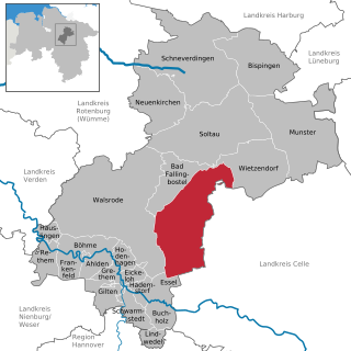
WThe Aller-Leine Valley is the name of a region north of Hanover in Germany, that has been created for the purpose of regional marketing and inter-community cooperation. The Aller-Leine Valley initially only included the three collective municipalities of Ahlden, Rethem an der Aller and Schwarmstedt in the district of Soltau-Fallingbostel, that are situated on the southwestern edge of the Lüneburg Heath where the River Leine discharges into the Aller. Since 2001 the neighbouring municipalities of Hambühren, Wietze and Winsen an der Aller as well as Dörverden and Kirchlinteln have become part of the Aller-Leine Valley region. The unifying theme and characteristic feature of the region is the river landscape of the Aller and Leine rivers.
 W
WAltes Land is an area of reclaimed marshland straddling parts of Lower Saxony and Hamburg. The region is situated downstream from Hamburg on the southwestern riverside of the Elbe around the towns of Stade, Buxtehude, Jork and the Samtgemeinde of Lühe. In Hamburg it includes the quarters of Neuenfelde, Cranz, Francop and Finkenwerder. Altes Land is one of the Elbe Marshes.
 W
WAngria or Angaria is a historical region in the present-day German states of Lower Saxony and North Rhine-Westphalia. The chronicler Widukind of Corvey in his Res gestae saxonicae sive annalium libri tres denoted it as the central region of the medieval Duchy of Saxony lying along the middle reaches of the Weser river between Westphalia and Eastphalia. Its name was derived from the Germanic Angrivarii tribe which had joined the Saxon tribal confederation, and it was centered on the town of Minden, see of a bishopric since 803.
 W
WBaltrum is a barrier island off the coast of East Frisia, in Germany, and is a municipality in the district of Aurich, Lower Saxony. It is located in-between the chain of the seven inhabited East Frisian Islands. Baltrum is the smallest island in this chain by area and inhabitants. It has a land area of 6.5 square kilometres, and a population in (2011) of just over 500 resident inhabitants.
 W
WBargebur is an urban quarter in the east of the borough of Norden, northwestern Germany, and has a population of around 500, who inhabit an area of just 0.65 km². The houses of Bargebur have been entirely absorbed within the built-up area of Norden. In the south of the quarter, separated by the B72, which acts as a ring road around Norden here, is the Tidofelder Holz, a forest in the neighbouring municipality of Lütetsburg. Along the Fehn Canal runs the so-called Verschönerungsweg. On old maps Bargebur is also called Bergum or Westekelbur.
 W
WBraunschweig was one of the eight former administrative regions (Regierungsbezirke) of Lower Saxony, Germany. It was located in the southeast of the state.
 W
WBullenhausen is a district of the municipality Seevetal in the county of Harburg in Lower Saxony.
 W
WEast Frisia or Eastern Friesland is a coastal region in the northwest of the German federal state of Lower Saxony. It is the section of Frisia in between West Frisia and Middle Frisia in the Netherlands and North Frisia in Schleswig-Holstein.
 W
WThe Ems Dollart Region (EDR), established in 1977, is a cross-border organisation located in the northern Dutch-German border area. The region is named after the Ems River and the Dollart estuary. Its aim is to establish and improve contacts and levels of interaction between people, companies and organisations within the border region. The organization is based in the Dutch village of Bad Nieuweschans. Here, the office has developed into a Dutch-German center, where cross-border functions and other activities take place. The office also serves as an administration base and launching point for many cross-border projects.
 W
WThe Solling Formation is a geologic formation in Germany. Formerly considered earliest Triassic (Induan), but later dating places the formation from the Olenekian to Anisian of the Triassic period.
 W
WForst is a district of the municipality Bevern, Lower Saxony, Germany.
 W
WThe Göttingen Forest is a ridge in Germany's Central Uplands that is up to 427.5 metres high. It forms part of the Lower Saxon Hills in South Lower Saxony.
 W
WThe Hamburg Metropolitan Region is a metropolitan area centred around the city of Hamburg in northern Germany, consisting of eight districts (Landkreise) in the federal state of Lower Saxony, six districts (Kreise) in the state of Schleswig-Holstein and two districts in the state of Mecklenburg-Vorpommern along with the city-state of Hamburg itself. It covers an area of roughly 26,000 square kilometres (10,000 sq mi) and is home to more than 5.1 million inhabitants.
 W
WThe Hannover–Braunschweig–Göttingen–Wolfsburg Metropolitan Region is an economic and cultural region in Northern Germany. The metropolitan area comprises approximately one third of the area of Lower Saxony, with almost half the inhabitants of the state. It has about 3.9 million people in 20 districts and counties with a total of 431 municipalities and is defined by the German Ministerkonferenz für Raumordnung (MKRO) as a medium urban area in Germany.
 W
WHanover was a Regierungsbezirk of the German state of Lower Saxony from 1946 until 2004. It was located in the south of the state, centered on the Lower Saxon capital of Hanover.
 W
WThe Harz Nature Park or just Harz Nature Park lies in the districts of Goslar and Göttingen in South Lower Saxony. The nature park in the Harz Mountains was founded in 1960 and is covers an area of around 790 km². It is run by the Harz Regional Association.
 W
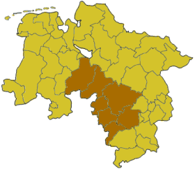
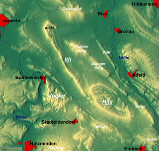
WThe Ith is a ridge in Germany's Central Uplands which is up to 439 m high. It lies about 40 km southwest of Hanover and, at 22 kilometres, is the longest line of crags in North Germany.
 W
WKalkriese is a village now administratively part of the city of Bramsche in the district of Osnabrück, Lower Saxony, Germany. It is on the northern slope of the Wiehen Hills, a ridge-like range of hills, north of Osnabrück. The Kalkrieser Berg or Schmittenhöhe, a hill with a height of 157 m (515 ft), is considered by archaeologists to be the likely site of the Battle of the Teutoburg Forest.
 W
WLand Hadeln is a historic landscape and former administrative district in Northern Germany with its seat in Otterndorf on the Lower Elbe, the lower reaches of the River Elbe, in the Elbe-Weser Triangle between the estuaries of the Elbe and Weser.
 W
WThe Lichtenstein Cave, discovered in 1972, is an archaeological cave site near Dorste, Lower Saxony, Germany with a length of 115 m (377 ft). The skeletal remains of 21 female humans and 19 males, dated to the Bronze Age, about 3,000 years ago were discovered. In addition, around 100 bronze objects and ceramic parts from the Urnfield Culture were found.
 W
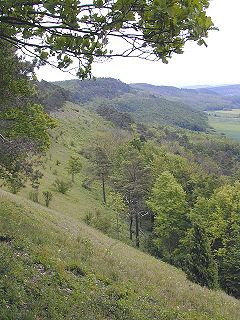
WLüneburg Heath is a large area of heath, geest, and woodland in the northeastern part of the state of Lower Saxony in northern Germany. It forms part of the hinterland for the cities of Hamburg, Hanover and Bremen and is named after the town of Lüneburg. Most of the area is a nature reserve. Northern Low Saxon is still widely spoken in the region.
 W
WThe Lüneburg Heath Wildlife Park is a wildlife park near Nindorf in the municipality of Hanstedt in the north German state of Lower Saxony. The park is home to around 1,000 animals of over 120 species in an area of 61 hectares. The park is open all year.
 W
WMagdalenengarten is a baroque park in Hildesheim in Lower Saxony, Germany.
 W
WThe Middle Weser Valley is part of the Weser Depression around the River Weser on the North German Plain, extending from the gap of Porta Westfalica to the town of Hoya. It is not a true valley, because it is only bordered by low hills at two points. It lies in the German federal states of Lower Saxony and North Rhine-Westphalia.
 W
WOsterheide is an unincorporated area in the district of Heidekreis, in Lower Saxony, Germany.
 W
WThe Rheiderland is a region of Germany and the Netherlands between the River Ems and the Bay of Dollart. The German part of the Rheiderland lies in East Frisia, west of the Ems. The Dutch part lies in the Dutch province of Groningen and is mostly part of Oldambt. The Rheiderland is one of the four historic regions on the mainland in the district of Leer; the others being the Overledingerland, the Moormerland and the Lengenerland.
 W
WRüstringen or Rustringen was an old Frisian gau which lay between the modern district Friesland and the Weser river in modern Lower Saxony. Nowadays, only a small part of the original territory remains, namely the Butjadingen peninsula. The largest part of historical Rüstringen has been lost to the sea in the Middle Ages due to various storm surges and now forms the Jadebusen bay.
 W
WStedingen is an area north of Bremen in the delta of the Weser river in north-western Germany.
 W
WWangerooge is one of the 32 Frisian Islands in the North Sea located close to the coasts of the Netherlands, Germany and Denmark. It is also a municipality in the district of Friesland in Lower Saxony in Germany.
 W
WThe Weper is a long, high ridge of hills up to 379 m above sea level (NN) located in the district of Northeim in the German state of Lower Saxony.
 W
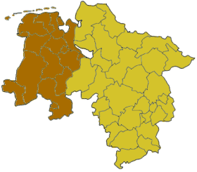
WThe Regierungsbezirk Weser-Ems was the most westerly of the four administrative regions of Lower Saxony, Germany, bordering on the Dutch provinces of Groningen, Drenthe and Overijssel. It was established in 1978 by merging the former regions Osnabrück, Aurich, and Oldenburg. It was formally dissolved by the end of 2004 along with the other Regierungsbezirke of Lower Saxony as part of an effort to optimize the administrative system of the state.