 W
WThe term "United States", when used in the geographical sense, is the contiguous United States, the state of Alaska, the island state of Hawaii, the five insular territories of Puerto Rico, Northern Mariana Islands, U.S. Virgin Islands, Guam, and American Samoa, and minor outlying possessions. The United States shares land borders with Canada and Mexico and maritime borders with Russia, Cuba, the Bahamas, and other countries, in addition to Canada and Mexico. The northern border of the United States with Canada is the world's longest bi-national land border.
 W
WThe Atlantic Northeast is a region of North America which includes the U.S. states of Connecticut, Massachusetts, Rhode Island, New Hampshire, Vermont, and Maine, and the Canadian provinces of Québec, Nova Scotia, New Brunswick, Prince Edward Island and Newfoundland and Labrador.
 W
WThe Big Eight States is a collective term with several definitions, most referring to states of the United States.
The United States Board on Geographic Names (BGN) is a federal body operating under the United States Secretary of the Interior. The purpose of the board is to establish and maintain uniform usage of geographic names throughout the federal government of the United States.
 W
WThe Borden Base Line is a historic survey line running north/south through Hatfield and South Deerfield, Massachusetts. It was completed in 1831, and is now on the List of historic civil engineering landmarks.
 W
WThe geographic center of the contiguous United States is the center of 48 U.S. states. It has been regarded as such by the U.S. National Geodetic Survey (NGS) since the 1912 additions of New Mexico and Arizona to the United States.
 W
WThe Continental Divide of the Americas is the principal, and largely mountainous, hydrological divide of the Americas. The Continental Divide extends from the Bering Strait to the Strait of Magellan, and separates the watersheds that drain into the Pacific Ocean from those river systems that drain into the Atlantic Ocean and, along the northernmost reaches of the Divide, those river systems that drain into the Arctic Ocean and Hudson Bay.
 W
WThis list of North American deserts identifies areas of the continent that receive less than 10 in (250 mm) annual precipitation. The "North American Desert" is also the term for a large U.S. Level 1 ecoregion (EPA) of the North American Cordillera, in the Deserts and xeric shrublands biome (WWF). The continent's deserts are largely between the Rocky Mountains and Sierra Madre Oriental on the east, and the rain shadow-creating Sierra Nevada, Transverse, and Peninsular Ranges on the west. The North American xeric region of over 95,751 sq mi (247,990 km2) includes: three major deserts; numerous smaller deserts; and large non-desert arid regions; in the western United States and in northeast, central, and northwest Mexico.
WThe Eastern Continental Divide or Eastern Divide or Appalachian Divide is a hydrographic divide in eastern North America that separates the easterly Atlantic Seaboard watershed from the westerly Gulf of Mexico watershed. The divide nearly spans the United States from south of Lake Ontario through the Florida peninsula, and consists of raised terrain including the Appalachian Mountains to the north, the southern Piedmont Plateau and lowland ridges in the Atlantic Coastal Plain to the south. Water including rainfall and snowfall, lakes, streams and rivers on the eastern/southern side of the divide drains to the Atlantic Ocean; water on the western/northern side of the divide drains to the Gulf of Mexico. The ECD is one of six continental hydrographic divides of North America which define several drainage basins, each of which drains to a particular body of water.
 W
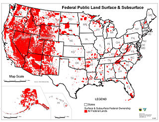
WFederal lands are lands in the United States owned by the federal government. Pursuant to the Property Clause of the United States Constitution, the Congress has the power to retain, buy, sell, and regulate federal lands, such as by limiting cattle grazing on them. These powers have been recognized in a long line of U.S. Supreme Court decisions.
 W
WThe Four Corners is a region of the United States consisting of the southwestern corner of Colorado, southeastern corner of Utah, northeastern corner of Arizona, and northwestern corner of New Mexico. The Four Corners area is named after the quadripoint at the intersection of approximately 37° north latitude with 109° 03' west longitude, where the boundaries of the four states meet, and are marked by the Four Corners Monument. It is the only location in the United States where four states meet. Most of the Four Corners region belongs to semi-autonomous Native American nations, the largest of which is the Navajo Nation, followed by Hopi, Ute, and Zuni tribal reserves and nations. The Four Corners region is part of a larger region known as the Colorado Plateau and is mostly rural, rugged, and arid. In addition to the monument, commonly visited areas within Four Corners include Monument Valley, Mesa Verde National Park, Chaco Canyon, Canyons of the Ancients National Monument and Canyon de Chelly National Monument. The most populous city in the Four Corners region is Farmington, New Mexico, followed by Durango, Colorado.
 W
WThe geographic center of the United States is a point approximately 20 mi (32 km) north of Belle Fourche, South Dakota at 44°58′2.07622″N 103°46′17.60283″W. It has been regarded as such by the U.S. National Geodetic Survey (NGS) since the additions of Alaska and Hawaii to the United States in 1959.
The Geographic Names Information System (GNIS) is a database that contains name and locative information about more than two million physical and cultural features located throughout the United States of America and its territories. It is a type of gazetteer. GNIS was developed by the United States Geological Survey in cooperation with the United States Board on Geographic Names (BGN) to promote the standardization of feature names.
 W
WThe United States was the first country to have Google Street View images and was the only country with images for over a year following introduction of the service on May 25, 2007. Early on, most locations had a limited number of views, usually constrained to the city limits and only including major streets, and they only showed the buildings up to a certain height. Few suburbs or other nearby cities were included.
 W
WThe Great Basin Divide in the western United States is the ridgeline that separates the Great Basin from the Pacific Ocean watershed, which completely surrounds it.
 W
WThe Interior Plains are a vast physiographic region that spreads across the Laurentian craton of central North America, extending from the Gulf Coast region to the Arctic Ocean along the east flank of the Rocky Mountains. In Canada, it separates the Rocky Mountains from the Canadian Shield, while in the U.S., it includes the Great Plains of the west and the Tallgrass prairie region to the south of the Great Lakes extending east to the Appalachian Plateau region.
 W
WThe international border states are those states in the U.S. that border either Canada, Mexico, Cuba, or Russia. With a total of eighteen of such states, thirteen lie on the U.S.–Canada border, four on the U.S.–Mexico border, and one consists of a maritime borders with Cuba and The Bahamas.
 W
WThis is a list of bridges and other crossings of the Rio Grande, from the Gulf of Mexico, upstream to its source.
 W
WThe List of snowiest places in the United States by state shows average annual snowfall totals for the period mid-1985 to mid-2015. Only places in the official climate database of the National Weather Service, a service of NOAA, are included in this list. Some ski resorts and unofficial weather stations report higher amounts of snowfall than places on this list. Official weather stations are usually located in populated places and snowfall statistics for isolated and unpopulated areas are often not recorded.
 W
WThis is a complete list of the U.S. states, federal district, and its major territories ordered by total area, land area, and water area. The water area includes inland waters, coastal waters, the Great Lakes, and territorial waters. Glaciers and intermittent bodies of water are counted as land area.
 W
WThe lot and block survey system is a method used in the United States and Canada to locate and identify land, particularly for lots in densely populated metropolitan areas, suburban areas and exurbs. It is sometimes referred to as the recorded plat survey system or the recorded map survey system.
 W
WThe Mesa Verde Region is a portion of the Colorado Plateau in the United States that extends through parts of New Mexico, Colorado and Utah. It is bounded by the San Juan River to the south, the Piedra River to the east, the San Juan Mountains to the north and the Colorado River to the west.
WIn the United States, a plat (plan) is a cadastral map, drawn to scale, showing the divisions of a piece of land. United States General Land Office surveyors drafted township plats of Public Lands Surveys to show the distance and bearing between section corners, sometimes including topographic or vegetation information. City, town or village plats show subdivisions broken into blocks with streets and alleys. Further refinement often splits blocks into individual lots, usually for the purpose of selling the described lots; this has become known as subdivision.
 W
WBecause of its unique history, many of the boundaries of the political divisions of the United States were artificially constructed. Therefore, many U.S. states have straight lines as boundaries, especially in the West. However, there are many partial state boundaries, particularly in the Midwest, Northeast, and South, that are defined by rivers; in fact, only five states completely lack any borders defined by rivers or waterways.
WThe Saint Lawrence River Divide is a continental divide in central and eastern North America that separates the Great Lakes-St. Lawrence River Basin from the southerly Atlantic Ocean watersheds. Water, including rainfall and snowfall, lakes, rivers and streams, north and west of the divide, drains into the Gulf of St. Lawrence or the Labrador Sea; water south and east of the divide drains into the Atlantic Ocean or Gulf of Mexico. The divide is one of six continental divides in North America that demarcate several watersheds that flow to different gulfs, seas or oceans.
 W
WThe subarctic zone is a region in the Northern Hemisphere immediately south of the true Arctic and covering much of Alaska, Canada, Iceland, the north of Scandinavia, Siberia, the Shetland Islands, and the Cairngorms. Generally, subarctic regions fall between 50°N and 70°N latitude, depending on local climates. Precipitation is low, and vegetation is characteristic of the taiga.
 W
WTime in the United States, by law, is divided into nine standard time zones covering the states, territories and other US possessions, with most of the United States observing daylight saving time (DST) for approximately the spring, summer, and fall months. The time zone boundaries and DST observance are regulated by the Department of Transportation. Official and highly precise timekeeping services (clocks) are provided by two federal agencies: the National Institute of Standards and Technology (NIST) ; and the United States Naval Observatory (USNO). The clocks run by these services are kept synchronized with each other as well as with those of other international timekeeping organizations.
 W
WThe United States Geological Survey is a scientific agency of the United States government. The scientists of the USGS study the landscape of the United States, its natural resources, and the natural hazards that threaten it. The organization's work spans the disciplines of biology, geography, geology, and hydrology. The USGS is a fact-finding research organization with no regulatory responsibility.
 W
WThe United States National Grid (USNG) is a multi-purpose location system of grid references used in the United States. It provides a nationally consistent "language of location", optimized for local applications, in a compact, user friendly format. It is similar in design to the national grid reference systems used in other countries. The USNG was adopted as a national standard by the Federal Geographic Data Committee (FGDC) of the US Government in 2001.
 W
WThe urbanization of the United States has progressed throughout its entire history. Over the last two centuries, the United States of America has been transformed from a predominantly rural, agricultural nation into an urbanized, industrial one. This was largely due to the Industrial Revolution in the United States in the late 18th and early 19th centuries and the rapid industrialization which the United States experienced as a result. In 1790, only about one out of every twenty Americans lived in urban areas (cities), but this ratio had dramatically changed to one out of four by 1870, one out of two by 1920, two out of three in the 1960s, and four out of five in the 2000s.
 W
WThe Yadkin–Pee Dee River Basin is a large river basin in the eastern United States, covering around 7,221 square miles, making it the second largest in the state of North Carolina. Its headwaters rise near Blowing Rock, North Carolina, and the basin drains to the Atlantic Ocean in Winyah Bay, east of Georgetown, South Carolina.