 W
WBaghmara is the headquarters of South Garo Hills district in the state of Meghalaya in India. The place is bordered by Bangladesh and is about 113 km from Tura. It has a famous river, Someshwari, also known as Simsang in Garo tribal language, flowing through its expanse and is also covered in hills and tracts along the way.
 W
WBalat is a town in the Indian state of Meghalaya.
WBetasing is the Community & Rural Development Block headquarters situated 7 km from the district headquarters of South West Garo Hills, Ampati.
 W
WBynther is a village that falls under the Mairang block of West Khasi Hills District in Meghalaya, India.The village is divided into mainly two parts: Upper Bynther and Lower Bynther. The famous folk singer Skendrowell Syiemlieh lived here.
WDalu is a village in West Garo Hills district, Meghalaya, India famous for coal export in North East India.
WDawki or Dauki is a town in West Jaintia Hills district, Meghalaya, India.
 W
WEast Garo Hills is an administrative district in the state of Meghalaya in India.
 W
WEast Jaintia Hills district is a district with its headquarters at Khliehriat in Meghalaya state of India. The district was carved out of Jaintia Hills district on 31 July 2012.
 W
WJorabat is a village, suburban fringe and a junction which covers area under both Ri-Bhoi district, Meghalaya, India and Kamrup Metropolitan district, Assam, India, with greater parts in Kamrup Metropolitan district of Assam and lesser southern parts in Ri-Bhoi district of Meghalaya.
 W
WThe Khasi Hills is a low mountain formation on the Shillong Plateau in Meghalaya state of India. The Khasi Hills are part of the Garo-Khasi-Jaintia range and connects with the Purvanchal Range and larger Patkai Range further east. Khasi Hills, and the whole Garo-Khasi-Jaintia range, are in the Meghalaya subtropical forests ecoregion.
 W
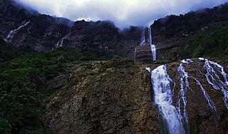
WThe Kynrem Falls is located 12 kilometres (7.5 mi) from Cherrapunji in East Khasi Hills district in the Indian state of Meghalaya. It is situated inside the Thangkharang Park. It is the 7th highest waterfalls in India. The Kynrem Falls is a three-tiered waterfall, with water falling from a height of 305 metres (1,001 ft).
WLaitumkhrah is a census town in Shillong, Meghalaya, India. The name of the place basically means a place where the river "Umkhrah" originates from making its name aptly suited.
 W
WThe Langshiang Falls is located near the village of Sangriang, 24 kilometres (15 mi) from Nongstoin, in West Khasi Hills district in the Indian state of Meghalaya. It can also be seen from Mawpon village.
WMadanrting is a census town in East Khasi Hills district in the Indian state of Meghalaya.
WMairang is a town and a town area committee in West Khasi Hills district in the Indian state of Meghalaya.It is located at about 40 km from the state capital Shillong,and 45 km(approx.) from the district headquarters, Nongstoin along National Highway 44E (Shillong-Nongstoin-Tura).
WMawlai is a census town in East Khasi Hills district in the Indian state of Meghalaya.
 W
WNohkalikai Falls is the tallest plunge waterfall in India. Its height is 1115 feet. The waterfall is located near Cherrapunji, one of the wettest places on Earth. Nohkalikai Falls are fed by the rainwater collected on the summit of a comparatively small plateau and decrease in power during the dry season in December - February. Below the falls there has formed a plunge pool with unusual green colored water.
 W
WNohsngithiang Falls is a seven-segmented waterfall located 1 kilometre (0.62 mi) south of Mawsmai village in East Khasi Hills district in the Indian state of Meghalaya. The water falls from a height of 315 metres (1,033 ft) and has an average width of 70 metres (230 ft). making it one of the tallest waterfalls in India.
 W
WNongkhnum River Island is the biggest river island in the Indian state of Meghalaya. The island is formed by the river Wah Kynshi on the west and south and river Namiliang on the north and east. Often erroneously claimed to be the second largest river island in Asia, especially for promoting tourism, there are numerous other river islands in Asia much bigger in size than the Nongkhnum Island.
WNongmensong is a census town in East Khasi Hills district in the Indian state of Meghalaya.
WNongpoh {IPA: nɒŋˈpɒ(ə)} is the administrative centre of Ri-Bhoi district in the Indian state of Meghalaya in the Republic of India. Nongpoh is located on National Highway 40, fifty-two kilometers from the state capital Shillong and forty-eight kilometers from Guwahati in the state of Assam.
WNongstoin is the headquarters of West Khasi Hills district in the state of Meghalaya in India.
WNongthymmai is a census town in East Khasi Hills district in the Indian state of Meghalaya.
WSaipung is a village in East Jaintia Hills district, Meghalaya, India. It is the headquarters of the Saipung Sub-Division. The population was 1,431 as per the 2011 Indian census. Located about 136 km from the state's capital Shillong, Saipung is inhabited by the Biate people.
WShillong Cantonment is a cantonment town in East Khasi Hills district in the Indian state of Meghalaya.
 W
WSiju Cave, also known as Bat Cave in English, is located in the North East Indian state of Meghalaya near the Napak Lake and Simsang River game reserve. It is a limestone cave and is famous for its stalagmites and stalactites.
 W
WSouth Garo Hills is an administrative district in the state of Meghalaya in India. As of 2011 it is the least populous district of Meghalaya. The district was established in 1992.
 W
WSouth West Khasi Hills is an administrative district in the state of Meghalaya in India.
 W
WUmiam Lake is a reservoir in the hills 15 km (9.3 mi) north of Shillong in the state of Meghalaya, India. It was created by damming the Umiam River in the early 1960s. The principal catchment area of the lake and dam is spread over 220 square km.
 W
WWah Kaba Falls is a waterfall located near Cherrapunji in Meghalaya, in the north eastern India. The waterfall descends from a steep rockface and drops approximately 170–190 metres into a gorge. There is a local legend that two fairies live at the falls. The falls can be seen on the way to Cherrapunji from Shillong.
WWest Khasi Hills is an administrative district in the state of Meghalaya in India.