 W
WAzad Jammu and Kashmir, abbreviated as AJK and colloquially referred to as simply Azad Kashmir, is a region administered by Pakistan as a nominally self-governing entity and constitutes the western portion of the larger Kashmir region, which has been the subject of a dispute between India and Pakistan since 1947. The territory shares a border to the north with Gilgit-Baltistan, together with which it is referred to by the United Nations and other international organizations as "Pakistani-administered Kashmir". Azad Kashmir also shares borders with the Pakistani provinces of Punjab and Khyber Pakhtunkhwa to the south and west, respectively. On its eastern side, Azad Jammu and Kashmir is separated from the Indian union territory of Jammu and Kashmir by the Line of Control (LoC), which serves as the de facto border between the Indian- and Pakistani-controlled parts of Kashmir. The administrative territory of Azad Jammu and Kashmir covers a total area of 13,297 km2 (5,134 sq mi) and has a total population of 4,045,366 as per the 2017 national census.
 W
WNorth Borneo was a British protectorate located in the northern part of the island of Borneo. The territory of North Borneo was originally established by concessions of the Sultanates of Brunei and Sulu in 1877 and 1878 to a German-born representative of Austria-Hungary, a businessman and diplomat, von Overbeck.
 W
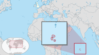
WThe British Indian Ocean Territory (BIOT) is a British overseas territory of the United Kingdom situated in the Indian Ocean halfway between Tanzania and Indonesia. The territory comprises the seven atolls of the Chagos Archipelago with over 1,000 individual islands – many very small – amounting to a total land area of 60 square kilometres (23 sq mi). The largest and most southerly island is Diego Garcia, 27 km2 (10 sq mi), the site of a joint military facility of the United Kingdom and the United States.
 W
WThe disputed territories of Northern Iraq are regions defined by article 140 of the Constitution of Iraq as being Arabised during Baath Party rule in Iraq. Most of these regions are inhabited by non-Arabs, including Kurds, Assyrians, Yazidis, Turkmens/Turkomans, and Shabaks.
 W
WDoklam, Zhoglam, or Donglang, is an area with a plateau and a valley, lying between China's Chumbi Valley to the north, Bhutan's Ha Valley to the east and India's Sikkim state's Nathang Valley to the west. It has been depicted as part of Bhutan in the Bhutanese maps since 1961, but it is also claimed by China. To date, the dispute has not been resolved despite several rounds of border negotiations between Bhutan and China. The area is of strategic importance to all three countries.
 W
WEast Jerusalem or Eastern Jerusalem is the sector of Jerusalem that was occupied by Jordan during the 1948 Arab–Israeli War, as opposed to the western sector of the city, West Jerusalem, which was occupied by Israel. Since the 1967 Arab–Israeli War, East Jerusalem has been considered occupied by Israel by the international community.
 W
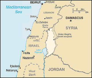
WGhajar is an Alawite-Arab village on the Hasbani River on the border between Lebanon and the Israeli-occupied portion of the Golan Heights, internationally considered to be de jure part of Syria. In 2019 it had a population of 2,659.
 W
WGilgit-Baltistan, formerly known as the Northern Areas, is a region administered by Pakistan as an administrative territory, and constituting the northern portion of the larger Kashmir region which has been the subject of a dispute between India and Pakistan since 1947, and between India and China from somewhat later. It is the northernmost territory administered by Pakistan. It borders Azad Kashmir to the south, the province of Khyber Pakhtunkhwa to the west, the Wakhan Corridor of Afghanistan to the north, the Xinjiang region of China, to the east and northeast, and the Indian-administered union territories Jammu and Kashmir and Ladakh to the southeast.
 W
WThe Golan Heights, or simply the Golan, is a region in the Levant, spanning about 1,800 square kilometers (690 sq mi). The region defined as the Golan Heights differs between disciplines: as a geological and biogeographical region, the Golan Heights refers to a basaltic plateau bordered by the Yarmouk River in the south, the Sea of Galilee and Hula Valley in the west, the Anti-Lebanon with Mount Hermon in the north and Wadi Raqqad in the east. As a geopolitical region, the Golan Heights refers to the area captured from Syria and occupied by Israel during the 1967 Six-Day War, territory which has been administered as part of Israel since 1981. This region includes the western two-thirds of the geological Golan Heights and the Israeli-occupied part of Mount Hermon.
 W
WHatay Province is Turkey's southernmost province. Almost all of it is located outside Anatolia, on the eastern coast of the Levantine Sea. The administrative capital is Antakya (Antioch), and the port city of İskenderun (Alexandretta). It is bordered by Syria to the south and east and the Turkish provinces of Adana and Osmaniye to the north. The province is part of Çukurova (Cilicia), a geographical, economical and cultural region that covers the provinces of Mersin, Adana, Osmaniye, and Hatay. There are border crossing points with Syria in the district of Yayladağı and at Cilvegözü in the district of Reyhanlı.
 W
WJammu and Kashmir was a region formerly administered by India as a state from 1954 to 2019, constituting the southern and southeastern portion of the larger Kashmir region, which has been the subject of a dispute between India, Pakistan and China since the mid-20th century. The underlying region of this state were parts of the former princely state of Jammu and Kashmir, whose western districts, now known as Azad Kashmir, and northern territories, now known as Gilgit-Baltistan, are administered by Pakistan. The Aksai Chin region in the east, bordering Tibet, has been under Chinese control since 1962.
 W
WJammu and Kashmir is a region which is administered by India as a union territory and consists of the southern portion of the larger Kashmir region, which has been the subject of a dispute between India and Pakistan since 1947, and between India and China since 1962. The region of Jammu and Kashmir is separated by the Line of Control from the Pakistani-administered territories of Azad Kashmir and Gilgit-Baltistan in the west and north, respectively. It lies to the north of the Indian states of Himachal Pradesh and Punjab and to the west of Ladakh, which is also subject to the dispute as a part of Kashmir, and administered by India as a union territory.
 W
WJerusalem is a city in the Middle East, on a plateau in the Judaean Mountains between the Mediterranean and the Dead Sea. It is one of the oldest cities in the world, and is considered holy to the three major Abrahamic religions—Judaism, Christianity, and Islam. Both Israel and the Palestinian Authority claim Jerusalem as their capital, as Israel maintains its primary governmental institutions there and the State of Palestine ultimately foresees it as its seat of power; however, neither claim is widely recognized internationally.
 W
WKashmir is the northernmost geographical region of the Indian subcontinent. Until the mid-19th century, the term "Kashmir" denoted only the Kashmir Valley between the Great Himalayas and the Pir Panjal Range. Today, the term encompasses a larger area that includes the Indian-administered territories of Jammu and Kashmir and Ladakh, the Pakistani-administered territories of Azad Kashmir and Gilgit-Baltistan, and Chinese-administered territories of Aksai Chin and the Trans-Karakoram Tract.
WThe Kashmir conflict is a territorial conflict over the Kashmir region, primarily between India and Pakistan, with China playing a third-party role. The conflict started after the partition of India in 1947 as both India and Pakistan claimed the entirety of the former princely state of Jammu and Kashmir with Pakistan recognizing Chinese sovereignty over the Trans-Karakoram Tract and Aksai Chin since 1963. It is a dispute over the region that escalated into three wars between India and Pakistan and several other armed skirmishes. India controls approximately 55% of the land area of the region that includes Jammu, the Kashmir Valley, most of Ladakh, the Siachen Glacier and 70% of its population, Pakistan controls approximately 30% of the land area that includes Azad Kashmir and Gilgit-Baltistan while China controls the remaining 15% of the land area that includes the Aksai Chin region, the mostly uninhabited Trans-Karakoram Tract, and part of the Demchok sector. After the partition of India and a rebellion in the western districts of the state, Pakistani tribal militias invaded Kashmir, leading the Hindu ruler of Jammu and Kashmir to join India and starting the Indo-Pakistani War of 1947 which ended with a UN-mediated ceasefire along a line that was eventually named the Line of Control. After further fighting in the Indo-Pakistani War of 1965 and the Indo-Pakistani War of 1971, the Simla Agreement formally established the Line of Control between the two nations' controlled territories. In 1999, armed conflict between India and Pakistan broke out again in the Kargil War over the Kargil district.
 W
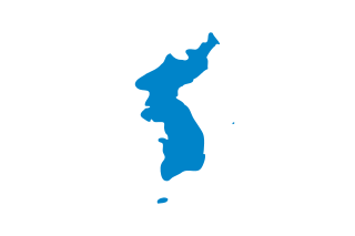
WKorea is a region in East Asia. Since 1945 it has been divided into two sovereign states: North Korea and South Korea. Korea consists of the Korean Peninsula, Jeju Island, and several minor islands near the peninsula. It is bordered by China to the northwest and Russia to the northeast. It is separated from Japan to the east by the Korea Strait and the Sea of Japan.
 W
WKowloon Walled City was an ungoverned, densely populated de jure Chinese enclave within the boundaries of Kowloon City, Hong Kong. Originally a Chinese military fort, the walled city became an enclave after the New Territories were leased to the UK by China in 1898. Its population increased dramatically following the Japanese occupation of Hong Kong during World War II. By 1990, the walled city contained 50,000 residents within its 2.6-hectare (6.4-acre) borders. From the 1950s to the 1970s, it was controlled by local triads and had high rates of prostitution, gambling, and drug abuse.
 W
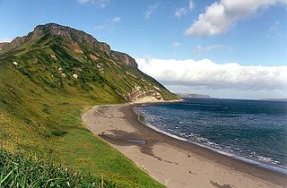
WThe Kuril Islands or Kurile Islands is a volcanic archipelago in Russia's Sakhalin Oblast that stretches approximately 1,300 km (810 mi) northeast from Hokkaido, Japan to Kamchatka, Russia, separating the Sea of Okhotsk from the north Pacific Ocean. There are 56 islands and many minor rocks. It consists of the Greater Kuril Chain and the Lesser Kuril Chain. The total land area is 10,503.2 square kilometres (4,055.3 sq mi), and the total population is 19,434.
 W
WLadakh is a region administered by India as a union territory, and constituting a part of the larger Kashmir region, which has been the subject of dispute between India, Pakistan, and China since 1947. It is bordered by the Tibet Autonomous Region to the east, the Indian state of Himachal Pradesh to the south, both the Indian union territory of Jammu and Kashmir and the Pakistan-administered Gilgit-Baltistan to the west, and the southwest corner of Xinjiang across the Karakoram Pass in the far north. It extends from the Siachen Glacier in the Karakoram range to the north to the main Great Himalayas to the south. The eastern end, consisting of the uninhabited Aksai Chin plains, is claimed by the Indian Government as part of Ladakh, and has been under Chinese control since 1962. Until 2019, Ladakh was a region of the state of Jammu and Kashmir. In August 2019, the Parliament of India passed an act by which Ladakh became a union territory on 31 October 2019.
 W
WThe Liancourt Rocks are a group of small islets in the Sea of Japan. While South Korea controls the islets, its sovereignty over them is contested by Japan.
 W
WNorthern Cyprus, officially the Turkish Republic of Northern Cyprus, is a de facto state that comprises the northeastern portion of the island of Cyprus. Recognised only by Turkey, Northern Cyprus is considered by the international community to be part of the Republic of Cyprus.
 W
WThe term "Palestinian territories" has been used for many years to describe the territories occupied by Israel since 1967, namely the West Bank and the Gaza Strip. More recently, the official United Nations (UN) terminology has been used, occupied Palestinian territory increasingly replacing other terms since 1999. The European Union (EU) also has adopted this usage. The term Occupied Palestinian Territory was used by the UN and other international organizations between October 1999 and December 2012 to refer to areas controlled by the Palestinian National Authority. The EU had utilized a parallel term Palestinian Authority territories occasionally during the same period. The International Court of Justice (ICJ) referred to the West Bank, including East Jerusalem, as "the Occupied Palestinian Territory" and this term was used as the legal definition by the ICJ in the ruling in July 2004.
 W
WArtsakh, officially the Republic of Artsakh or the Nagorno-Karabakh Republic, is a breakaway state in the South Caucasus supported by Armenia, whose territory is internationally recognized as part of Azerbaijan. Artsakh controls a part of the former Nagorno-Karabakh Autonomous Oblast, and a 5km wide corridor connecting it to Armenia. Its capital is Stepanakert.
 W
WRocky Island is one of the Paracel Islands in the South China Sea. It is under the administration of the People's Republic of China and guarded by the PLA Navy. The island is also claimed by Taiwan and Vietnam.
 W
WThe seizure of Abu Musa and the Greater and Lesser Tunbs by Imperial Iranian Navy forces took place on 30 November 1971, after the withdrawal of British forces from the islands of Abu Musa and the Greater Tunb and Lesser Tunb, which are located in the Strait of Hormuz. The islands had been claimed by Iran and by the newly formed United Arab Emirates as a territory of the Emirate of Ras Al Khaimah. Iran has maintained military control of the islands since, while the UAE has made several attempts through international channels to regain control of the islands.
 W
WThe Siachen Glacier is a glacier located in the eastern Karakoram range in the Himalayas at about 35.421226°N 77.109540°E, just northeast of the point NJ9842 where the Line of Control between India and Pakistan ends. At 76 km (47 mi) long, it is the longest glacier in the Karakoram and second-longest in the world's non-polar areas. It falls from an altitude of 5,753 m (18,875 ft) above sea level at its head at Indira Col on the China border down to 3,620 m (11,875 ft) at its terminus. The entire Siachen Glacier, with all major passes, has been under the administration of India since 1984. Pakistan maintains a territorial claim over the Siachen Glacier and controls the region west of Saltoro Ridge, lying west of the glacier, with Pakistani posts located 3,000 ft below more than 100 Indian posts on the ridge.
 W
WSir Creek, originally Ban Ganga, is a 96-km (60-mi) tidal estuary in the uninhabited marshlands of the Indus River Delta on the border between India and Pakistan. The creek flows into the Arabian Sea and separates Gujarat state in India from Sindh province in Pakistan. The long-standing India-Pakistan Sir Creek border dispute stems from the demarcation "from the mouth of Sir Creek to the top of Sir Creek, and from the top of Sir Creek eastward to a point on the line designated on the Western Terminus". From this point onward, the boundary is unambiguously fixed as defined by the Tribunal Award of 1968.
 W
WThe South China Sea Islands consist of over 250 islands, atolls, cays, shoals, reefs and seamounts in the South China Sea. The islands are mostly low and small, and have few inhabitants. The islands and surrounding seas are subject to overlapping territorial claims by the countries bordering the South China Sea.
 W
WThe Syngman Rhee Line refers to a marine boundary line established by South Korean President Syngman Rhee in his "Peace Line" declaration of January 18, 1952, establishing a wide area of maritime sovereignty, beyond internationally accepted territorial waters, around the entire Korean Peninsula. This included placing the Liancourt Rocks (Dokdo/Takeshima) in South Korean territory.
 W
WThe polity of Tibet between the collapse of the Qing dynasty in 1912 and the annexation by the People's Republic of China in 1951 was a de facto independent state comprising the western half of the Tibetan Plateau.
WWoody Island, also called Yongxing Island in People's Republic of China (PRC) and Phu Lam Island in Vietnam, is the largest of the Paracel Islands in the South China Sea (SCS), with an area of 2.1 square kilometres (0.81 sq mi). It has a population of more than 1,000 people, with roads, banks and a "small" air strip. The Paracel Islands are a group of islands, reefs, banks and atolls in the northwestern part of the South China Sea. Woody Island is part of the Amphitrite Group in the eastern Paracels and is approximately equidistant from Hainan and the Vietnam coast.
 W
WZogam known as Zoland, Lushai Hills, Kuki Hills, lies in the northwest corner of the Mainland Southeast Asia landmass. This is the traditional ancestry homeland of the Zo people or Zomi who lived in this area before the colonial period under British rulership.