 W
WBallynacregga is a town in County Galway, Ireland. Ballynacregga is on the eastern shore of Lough Corrib. It is in a northern part of County Galway, near the border of County Mayo.
 W
WBallynastaig Wood is a nature reserve of approximately 25 acres (0.10 km2) located in County Galway, Ireland.
 W
WBen Lugmore at 803 metres (2,635 ft) is the 29th-highest peak in Ireland on the Arderin scale, and the 37th-highest peak on the Vandeleur-Lynam scale. It is in a horseshoe-shaped massif that includes the slightly higher peak of Mweelrea at 814 metres (2,671 ft), the highest mountain in the Irish province of Connacht. The massif is between Killary Harbour and Doo Lough, in Mayo.
 W
WBenbrack at 582 metres (1,909 ft), is the 251st–highest peak in Ireland on the Arderin scale; while it does not have the elevation to be a Vandeleur-Lynam, it has the prominence to rank as a Marilyn. Benbrack is situated on its own small massif to the north of the core Twelve Bens mountain range in the Connemara National Park in Galway, Ireland. It is the 10th-tallest of the core Twelve Bens, and is linked by a deep col to Muckanaght, which is itself attached by a high ridge to the tallest mountain of the Twelve Bens range, Benbaun at 729 metres (2,392 ft).
 W
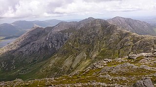
WBenbreen at 691 metres (2,267 ft), is the 100th–highest peak in Ireland on the Arderin scale, and the 122nd–highest peak on the Vandeleur-Lynam scale. Benbreen lies in the southern end of the Twelve Bens mountain range in the Connemara National Park in Galway, Ireland. Benbreen is the 4th-tallest mountain of the Twelve Bens range, after Benbaun 729 metres (2,392 ft), Bencorr 711 metres (2,333 ft), and Bencollaghduff 696 metres (2,283 ft). Benbreen's profile is of a "high narrow rocky ridge with several summits", than a typical "peaked mountain".
 W
WBencollaghduff at 696 metres (2,283 ft), is the 93rd–highest peak in Ireland on the Arderin scale, and the 115th–highest peak on the Vandeleur-Lynam scale. Bencollaghduff is situated near the centre of the core massif of the Twelve Bens mountain range in the Connemara National Park in Galway, Ireland. It is the 3rd tallest mountain of the Twelve Bens range, after Benbaun 729 metres (2,392 ft), to which it is connected by the northern col of Maumina; and after Bencorr 711 metres (2,333 ft), to which it is connected by a high southeast rocky ridge.
 W
WBencorr at 711 metres (2,333 ft), is the 82nd–highest peak in Ireland on the Arderin scale, and the 102nd–highest peak on the Vandeleur-Lynam scale. Bencorr is situated near the centre of the core massif of the Twelve Bens mountain range in the Connemara National Park in Galway, Ireland. It is the second-tallest mountain of the Twelve Bens range, after Benbaun 729 metres (2,392 ft); it lies close to Benbaun, separated only by the third-highest mountain in the range of Bencollaghduff 696 metres (2,283 ft), and the col of Maumina.
 W
WBenglenisky at 516 metres (1,693 ft), is the 368th–highest peak in Ireland on the Arderin scale. Benglenisky is the second most southern peak, after neighbouring Benlettery, of the Twelve Bens mountain range in the Connemara National Park in Galway, Ireland, and is the lowest of the core Twelve Bens.
 W
WBengower at 664 metres (2,178 ft), is the 135th–highest peak in Ireland on the Arderin scale, and the 166th–highest peak on the Vandeleur-Lynam scale. Bengower is in the southern end of the Twelve Bens mountain range in the Connemara National Park in Galway, Ireland, and is the 6th-tallest of the core Twelve Bens.
 W
WBenlettery at 557 metres (1,827 ft), is the 259th–highest peak in Ireland on the Arderin scale. Benlettery is in the southernmost peak of the Twelve Bens mountain range in the Connemara National Park in Galway, Ireland, and is the 11th-tallest of the core Twelve Bens. The Ben Lettery An Oige youth hostel is on the southern slopes of Benlettery, off the N59 road to Clifden.
 W
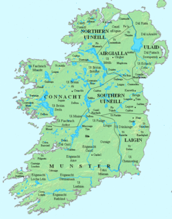
WCenél Áeda na hEchtge was a trícha cét (later a cantred, and which was the original formation of the southern part of the barony of Kiltartan, County Galway. This was the clan name of the O Shaughnessys and O Cahills who both ruled the territory until the O Cahills were forced from the area by the O Shaughnessys. The latter remained chiefs of the area until 1691 and the head family survived in the Gort area till the demise of the senior line in the 18th century. The name was taken after the cenél of Aedh, uncle to King Guaire Aidne mac Colmáin of Connacht.
WClann Fhergail was a cantred located in County Galway, comprising the baronies of Moycullen and Galway, the parishes of Oranmore and Ballynacourty and Rahoon.
WClann Taidg was the name of a medieval cantred located in what is now County Galway, Ireland.
 W
WConnemara is a cultural region in County Galway, Ireland. The area has a strong association with traditional Irish culture and contains a major part of the Connacht Irish-speaking Gaeltacht, which is a key part of the identity of the region and is the largest Gaeltacht in the country.
 W
WConnemara National Park is one of six national parks in Ireland that are managed by the National Parks and Wildlife Service of the Department of Culture, Heritage and the Gaeltacht. It is located in the west of Ireland within County Galway.
 W
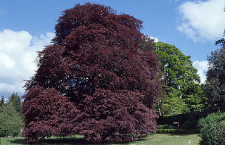
WCoole Park is a nature reserve of approximately 1,000 acres (4 km2) located a few miles west of Gort, County Galway, Ireland. It is managed by the Irish National Parks & Wildlife Service, part of the Department of Arts, Heritage and the Gaeltacht. The park is in a low–lying karstic limestone area characterised by seasonal lakes, known as turloughs, which are almost unique to Ireland. It has extensive woodlands. There are 6 kilometres of signposted nature trails plus a formal late 18th century walled garden.
WDelbhna Tír Dhá Locha was a tuath of Gaelic Ireland, located in the west of Ireland in what is now Co. Galway.
 W
WDerryclare at 677 metres (2,221 ft), is the 119th–highest peak in Ireland on the Arderin scale, and the 145th–highest peak on the Vandeleur-Lynam scale. Derryclare is situated at the far southern end of Twelve Bens mountain range in the Connemara National Park in Galway, Ireland. It is the 5th tallest of the core Twelve Bens. The Derryclare Lough on its southern slopes is a scenic location in Connemara, while the Derryclare Wood, on its eastern slopes, contains a Statutory Nature Reserve (SRN).
WDerrycrag Wood Nature Reserve is a national nature reserve and Special Area of Conservation of approximately 273 acres (1.10 km2) located near Woodford, County Galway, Ireland. It is managed by the Irish National Parks & Wildlife Service.
 W
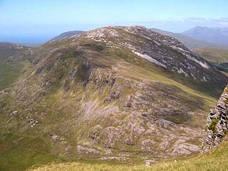
WDiamond Hill at only 442 metres (1,450 ft), does not rank as an Arderin, or a Vandeleur-Lynam; however, it has the prominence to rank as a Marilyn. Diamond Hill is an isolated peak, situated beside the village of Letterfrack, in the northwest corner of the Twelve Bens in the Connemara National Park in Galway, Ireland. It lies just west of Knockbrack and the small massif of Benbrack, and looks into the Polladirk valley, around which several major Bens are located. Despite its moderate size and isolated position, Diamond Hill is a popular peak with tourists due to its paths and boarded mountain trail, and relative ease of access, together with well-regarded views of the core Twelve Bens range, and western Connemara.
 W
WWest Connacht was a kingdom of Gaelic Ireland, associated geographically with present-day County Galway, particularly the area known more commonly today as Connemara. The kingdom represented the core homeland of the Connachta's Uí Briúin Seóla kindred and although they ruled, there were smaller groups of other Gaels in the area, such as the Delbhna Tir Dha Locha and the Conmhaícne Mara. It existed from 1051 onwards, after the Ó Conchobhair, Kings of Connacht, pushed the Ó Flaithbheartaigh to the West of Lough Corrib, from their original territory of Maigh Seóla. Iar Connacht remained a subordinate túath of Connacht, until the 13th century, after which it was more independent.
WMaigh Seóla, also known as Hy Briuin Seola, was the territory that included land along the east shore of Lough Corrib in County Galway, Ireland. It was bounded to the east by the Uí Maine vassal kingdom of Soghain and extended roughly from what is now Clarinbridge in the south to Knockmaa Hill in the north. Its rulers belonged to the Uí Briúin Seóla and are sometimes found in the annals under the title "King of Uí Briúin" and "King of South Connacht". The earliest identifiable kings belonged to the line that became the Clann Cosgraigh. However in later times the line which would become the Muintir Murchada, under the O'Flaherty chiefs, monopolized the kingship.
WMuintir Murchada was the name of an Irish territory which derived its name from the ruling dynasty, who were in turn a branch of the Uí Briúin. The name was derived from Murchadh mac Maenach, King of Uí Briúin Seóla, who died 891.
 W
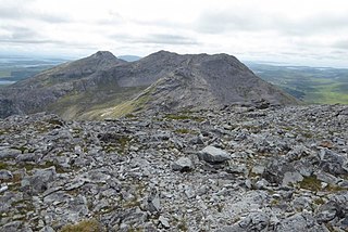
WMweelrea at 814 metres (2,671 ft), is the 26th-highest peak in Ireland on the Arderin scale, and the 34th-highest peak on the Vandeleur-Lynam scale. Mweelrea is situated near the apex of a "horseshoe-shaped" massif that includes the peaks of Ben Lugmore and Ben Bury, and which is located between Killary Harbour and Doo Lough, in Mayo, Ireland. Mweelrea is the provincial top for Connacht, and is noted for its southeastern cliff lined corries, and its views. The massif is called the Mweelrea Mountains or the Mweelrea Range.
WPollnaknockaun Wood is a national nature reserve and Special Area of Conservation of approximately 96 acres (0.39 km2) located near Woodford, County Galway, Ireland. It is managed by the Irish National Parks & Wildlife Service.
WRichmond Esker is a national nature reserve of approximately 39 acres (0.16 km2) located near Moylough, County Galway, Ireland. It is managed by the Irish National Parks & Wildlife Service.
WRosturra Wood is a national nature reserve and Special Area of Conservation of approximately 44 acres (0.18 km2) located near Woodford, County Galway, Ireland. It is managed by the Irish National Parks & Wildlife Service.
WThe Senchineoil was the name of the early rulers, possibly pre-Gaelic, of what is now central and east County Galway and south County Roscommon, Ireland.
WSíol Anmchadha was a sub-kingdom or lordship of Uí Maine, and ruled by an offshoot of the Uí Maine called the Síol Anmchadha, from whom the territory took its name. It was located in Connacht, Ireland.
WUí Díarmata was a local kingdom located in what is now north County Galway.
WUí Mháine, often Anglicised as Hy Many, was one of the oldest and largest kingdoms located in Connacht, Ireland. Its territory of approximately 1,000 square miles (2,600 km2) encompassed all of what is now north, east and south County Galway, south and central County Roscommon, an area near County Clare, and at one stage had apparently subjugated land on the east bank of the Shannon, together with the parish of Lusmagh in Offaly.
 W
WThe Western Way is a long-distance trail in Ireland. It is 179 kilometres long and begins in Oughterard, County Galway and ends in Ballycastle, County Mayo. It is typically completed in seven days. It is designated as a National Waymarked Trail by the National Trails Office of the Irish Sports Council and is managed by Coillte, Galway County Council, Mayo County Council, South Mayo Development Company and Mayo North & East Development Company.