 W
WThe Aba River is a river in southern Nigeria. It runs through the city of Aba, Nigeria. It is a tributary of the Imo River. Its headwaters are in Okpu-Umuobo in the Ngwa heartland into the Aba City.
 W
WAkure Forest Reserve is a protected area in southwest Nigeria, covering 66 km2 (25 sq mi).
WThe Akure Ofosu Forest Reserve is situated in SW Nigeria, and covers 394 km2 (152 sq mi).
 W
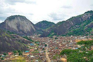
WArigidi is a town in Akoko North-West, Ondo State, Nigeria.
 W
WCross River is the main river in southeastern Nigeria and gives its name to Cross River State. It originates in Cameroon, where it takes the name of the Manyu River. Although not long by African standards its catchment has high rainfall and it becomes very wide. Over its last 80 kilometres (50 mi) to the sea its flows through swampy rainforest with numerous creeks and forms an inland delta near its confluence with the Calabar River, about 20 kilometres (12 mi) wide and 50 kilometres (31 mi) long between the cities of Oron on the west bank and Calabar, on the east bank, more than 30 kilometres (19 mi) from the open sea. The delta empties into a broad estuary which it shares with a few smaller rivers. At its mouth in the Atlantic Ocean, the estuary is 24 kilometres (15 mi) wide. The eastern side of the estuary is in the neighbouring country of Cameroon.
 W
WThe Donga River is a river in Nigeria and Cameroon. The river arises from the Mambilla Plateau in Eastern Nigeria, forms part of the international border between Nigeria and Cameroon, and flows northwest to eventually merge with the Benue River in Nigeria. The Donga watershed is 20,000 square kilometres (7,700 sq mi) in area. At its peak, near the Benue the river delivers 1,800 cubic metres (64,000 cu ft) of water per second.
 W
WThe Faro River is a 310-kilometre-long (190 mi) river that flows over the Nigeria–Cameroon border in Africa. Its source is on the Adamawa Plateau, which lies southeast of Ngaoundéré. A tributary of the Benue River, they meet on the border.
 W
WThe Gongola River is in northeastern Nigeria, the principal tributary of the Benue River. The upper course of the river as well as most of its tributaries are seasonal streams, but fill rapidly in August and September. The Gongola rises on the eastern slopes of the Jos Plateau and falls to the Gongola Basin, running northeasterly until Nafada. At one time, the Gongola continued from here in the northeast direction to Lake Chad. Today it turns south and then southeast until it joins the Hawal River, its main tributary. The Gongola then runs south to the Benue river, joining it opposite the town of Numan.
 W
WThe Goulbi de Maradi is a river in south central Niger and north central Nigeria. Between its source near Katsina in Nigeria, and its end in the Rima River, the Goulbi de Maradi never flows more than 48 kilometres (30 mi) from the Niger–Nigeria border. Though important for agriculture and pastoralism, and flowing through the Niger cities of Maradi, Guidan Roumdji, and Madarounfa, the Goulbi de Maradi is a seasonal river and flows only during the rainy season.
 W
WThe Hadejia River is a river in northern Nigeria and is a tributary of the Yobe River. Among the cities and towns that lie on or near its banks are Hadejia and Nguru. Damming of the river for the purposes of irrigation has led to a decrease in the amount of water in the Hadejia-Nguru wetlands, which the river forms along with Nguru Lake. The Hadejia river is now 80% controlled by the Tiga and Challawa Gorge dams in Kano State.
 W
WIdanre is a Local Government Area and historic town in Ondo State, Nigeria. The town is located at the foot of the scenic Idanre Hill which is of unique cultural and environmental significance, and attracts many tourists.
WIdanre Forest Reserve is in Idanre local government area of the Nigerian state of Ondo, in the south-west part of the country. This International Union for Conservation of Nature designated nature reserve covers 561 square kilometres (217 sq mi).
WIkale or old Ikale local government is Yoruba tribes in Ondo state Nigeria.It originally included what is now irele Local government. Which was split into Irele and Okitipupa local government. Irele is a Local Government Area in Ondo State, Nigeria. Its headquarters are in the town of Ode-Irele.
WIsarun or Isharun is a village in Ifedore, Ondo State, Nigeria. It lies 24km of Akure the state capital. The village gained international attraction in 1922 when a hunter, Chief Obele, first discovered the Cave of Ashes or.
WThe Jama'are River, also known as the Bunga River in its upper reaches, starts in the highlands near Jos, Plateau State, Nigeria and flows northeast through Bauchi State and Yobe State before joining the Hadejia River to form the Yobe River. There has recently been controversy over a plan to build the Kafin Zaki Dam on this river, with concerns over the effect on seasonal flooding and the water table.
WKa River is a river in the northern part of Nigeria. Originating in Zamfara State, it runs some 250 kilometres (160 mi) west into Kebbi State where it joins with the Sokoto River about 100 kilometres (62 mi) south of Birnin Kebbi, shortly before joining the Niger River.
 W
WThe Kaduna River is a tributary of the Niger River which flows for 550 kilometres (340 mi) through Nigeria. It got its name from the crocodiles that lived in the river and surrounding area. Kaduna in the native dialect, Hausa, was the word for "crocodiles". It starts in Plateau State on the Jos Plateau 29 kilometres (18 mi) southwest of Jos town, flows through its namesake Kaduna State and through its capital Kaduna, and meets the Niger River in Niger State. Most of its course passes through open savanna woodland, but its lower section has cut several gorges above its entrance into the extensive Niger floodplains.
 W
WThe Katsina Ala is a river in central Nigeria, located within its Middle Belt. It serves as a major tributary of the Benue River in Nigeria. The source of the river is found in the Bamenda highlands in northwestern Cameroon. It flows 320 kilometres (200 mi) northwest in Cameroon, crossing the Nigeria–Cameroon border into Nigeria.
 W
WThe Mandara Mountains are a volcanic range extending about 190 km along the northern part of the Cameroon–Nigeria border, from the Benue River in the south to the north-west of Maroua in the north. The highest elevation is the summit of Mount Oupay, at 1,494 m (4,900 ft) above sea level.
WMgbidi is the headquarters of Oru West, a local government area of Imo State in southeastern Nigeria. It is located at latitude 5.37° N and longitude 6.57° E. It was the headquarters of the Oru Local Government Area before its division into two local government areas, Oru West and Oru East, in 1996 under the presidency of Sani Abacha.
 W
WThe Ngadda River is a river in Nigeria that flows into Lake Chad and the Chad Basin. The Alau dam built on the river has interfered with fertile seasonal floodplains in the region of Maiduguri.
WNkporo is a town in Abia State, in southeastern Nigeria, traditionally an Igbo speaking region. And it is in Ohafia Local Government Area.
 W
WNorth-Eastern State is a former administrative division of Nigeria. It was created on 27 May 1967 from parts of the Northern Region. Its capital was the city of Maiduguri. The North-Eastern is also full of agriculture and food.
 W
WThe Nun River is a river in Rivers State, Nigeria. The Nun is formed when the Niger River splits in two, forming the Nun and Forcados rivers.
 W
WOguta Lake is a lean 'finger lake' formed by the damming of the lower Njaba River with alluvium. It is the largest natural lake in Imo State, Southeastern Nigeria; within the equatorial rainforest region of Niger Delta. Oguta Lake's catchment area comprises the drainage area of the Njaba River and a part of the River Niger floodplain in the region south of Onitsha.
 W
WThe Okpara River is a river of Benin. Originating in Borgou Department, it flows south and becomes the border between Nigeria and Benin before re-entering Benin and flowing into the Ouémé River, which ultimately drains into the Atlantic Ocean. Several villages along the river are disputed between Benin and Nigeria.
 W
WThe Otamiri River is one of the main rivers in Imo State, Nigeria. The river takes its name from Ota Miri, a deity who owns all the waters that are called by his name, and who is often the dominating god of Mbari houses. The river runs south from Egbu past Owerri and through Nekede, Ihiagwa, Eziobodo, Olokwu Umuisi, Mgbirichi and Umuagwo to Ozuzu in Etche, in the Rivers State, from where it flows to the Atlantic Ocean. The length of the river from its source to its confluence at Emeabiam with the Uramiriukwa River is 30 kilometres (19 mi).
 W
WThe Ouémé River, also known as the Weme River, is a river in Benin. It rises in the Atakora Mountains, and is about 510 kilometres (320 mi) long. It flows past the towns of Carnotville and Ouémé to a large delta on the Gulf of Guinea near the seaport city of Cotonou. The largest tributaries are the Okpara River and the Alpouro River. Ouémé River is the largest River of Benin Republic. It is located between 6° 30° and 10° north latitude and 0° 52 'and 3° 05' east longitude(Oba S. Alain 2018). It crosses several agro-ecological zones and feeds downstream, the lagoon system ‘'Lake Nokoué-lagoon of Porto-Novo'’ through a Delta zone. The lower Delta of Ouémé, is located between latitude 6° 33'N and 8° 15 'and the meridians 1° 50' and 2° 00 '. The lower Delta of Ouémé begins after municipality of Adjohoun in the department of Ouémé and ends at the south facade where the river flows into the lagoon complex ‘'Nokoué-Porto-Novo'’. The subequatorial climate type, characterized by two rainy seasons and two dry seasons. On the other hand, its hydrological regime depends on the Sudanian climate (north-Benin) with a low water period usually lasts seven months and a flood period. The plant formations along the area are characterized by swamps inhabited by floating plants dominated by water hyacinth, water lily, water lettuce and lemna. There are also undeveloped marshy forests, dominated by the Raphia palm and the oil palm. The part of the valley covered by the water is very productive in fish.
WThe Rima River is a river in the northern part of Nigeria. At its northernmost point it is joined by the Goulbi de Maradi river. It runs southwest and joins the Sokoto River near Sokoto, then continues south to the Niger River. The upper Rima is a seasonal river and flows only during the rainy season. The Zauro polder project, a major irrigation scheme, has been planned for many years. It would irrigate 10,572 hectares of farmland in the Rima floodplain between Argungu and Birnin Kebbi.
WThe Sokoto River is a river in north-west Nigeria and a tributary of the River Niger. The river's source is near Funtua in the south of Katsina State, some 275 kilometres (171 mi) in a straight line from Sokoto. It flows north-west passing Gusau in Zamfara State, where the Gusau Dam forms a reservoir that supplies the city with water. Further downstream the river enters Sokoto State where it passes by Sokoto and is joined by the Rima River, then turning south and flowing through Birnin Kebbi in Kebbi State. About 120 kilometres (75 mi) south of Birnin Kebbi, it reaches its confluence with the Niger River.
WThe Yobe River, also known as the Komadougou Yobe or the Komadougou-Yobe, is a river in West Africa that flows into Lake Chad through Nigeria and Niger. Its tributaries include the Hadejia River, the Jama'are River, and the Komadugu Gana River. The river forms a small part of the international border between Niger and Nigeria.
WThe Zamfara River is a river in the northern part of Nigeria. Originating in Zamfara State, it runs some 250 kilometres (160 mi) west into Kebbi State where it joins with the Sokoto River some 50 kilometres (31 mi) southwest of Birnin Kebbi.