 W
WAikawa was a town located in Kitaakita District, Akita Prefecture, Japan.
 W
WAkita-Komagatake (秋田駒ヶ岳) is an active stratovolcano located 10 km east of Tazawa Lake, near the border between Akita and Iwate prefectures on Honshu Island. The volcano last erupted from 18 September 1970 to 25 January 1971. It is the highest mountain in Akita Prefecture and the second highest in Towada-Hachimantai National Park.
 W
WAni was a town located in Kitaakita District, Akita Prefecture, Japan.
 W
WChagama Falls is a waterfall in the Hachimantai district of Kazuno, Akita Prefecture, Japan, on the Yoakeshima branch of the Yoneshiro River. It is one of "Japan’s Top 100 Waterfalls", in a listing published by the Japanese Ministry of the Environment in 1990. The falls have a height of 100 meters, making it one of the tallest on the list of 100 Waterfalls. The falls are also one of the most remotely located on the listing, requiring a hike of 5.5 kilometers across very rough terrain to reach.
 W
WChōkai was a town located in Yuri District, Akita Prefecture, Japan.
 W
WHachimori was a town located in Yamamoto District, Akita Prefecture, Japan.
 W
WHigashiyuri was a town located in Yuri District, Akita Prefecture, Japan.
 W
WHiroomote is a neighbourhood located in Akita City, Akita Prefecture, Japan. Annexed by the city in 1941, it borders the neighborhoods of Shimokitate on the east, Yanagida on the north, Tegata on the west and Sakura and Yokomori on the south that is bounded by Taihei River. Developed primarily in the post-World War II era, it is residential with commercial uses fronting prefectural roads #41, #28 and #62. The neighborhood is the location of the Akita University Hospital and Hiroomote Shopping Center.
 W
WHottai Falls is a waterfall in the city of Yurihonjō, Akita Prefecture, Japan, on the Akasawa River, a tributary of the Koyoshi River system in the foothills of Mount Chōkai. It is one of "Japan’s Top 100 Waterfalls", in a listing published by the Japanese Ministry of the Environment in 1990.
 W
WIwaki was a town located in Yuri District, Akita Prefecture, Japan.
 W
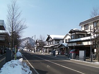
WKakunodate was a town located in Senboku District, Akita Prefecture, Japan. In 2003, the town had an estimated population of 14,138 and a density of 90.26 persons per km². The total area was 156.63 km².
 W
WKawabe was a town located in Kawabe District, Akita Prefecture, Japan.
 W
WKisakata was a town located in Yuri District, Akita Prefecture, Japan.
 W
WKyōwa was a town located in Senboku District, Akita Prefecture, Japan.
 W
WMinehama was a village located in Yamamoto District, Akita Prefecture, Japan.
 W
WMoriyoshi was a town located in Kitaakita District, Akita Prefecture, Japan.
 W
WNanataki Falls is a waterfall in the Hachimantai district of Kosaka, Akita Prefecture, Japan, on the Kosaka branch of the Yoneshiro River. It is one of "Japan’s Top 100 Waterfalls", in a listing published by the Japanese Ministry of the Environment in 1990. The falls have a height of 60 meters, broken into a series of seven cascades. The falls are easily accessible by car, and are located 8 kilometers from the Kosaka Interchange on the Tōhoku Expressway.
 W
WNangai was a village located in Senboku District, Akita Prefecture, Japan.
 W
WNaso no Shirataki is a waterfall located in Nikaho, Akita Prefecture, Japan. It became a nationally designated Place of Scenic Beauty in 1932.Although not selected as one of "Japan’s Top 100 Waterfalls", it was included in the listing of the "100 New Tourist Attractions of Japan" in a contest sponsored by the Mainichi Shinbun newspaper in 1950.
 W
WŌfuka onsen is an onsen in Semboku, Akita, Japan.
 W
WThe Oga Peninsula is a rugged peninsula which projects west into the Sea of Japan from the coast of Akita in northern Honshū, the main island of Japan. Politically it coincides with the city of Oga.
 W
WOgachi was a town located in Ogachi District, Akita Prefecture, Japan.
 W
WThe Omono River is located in Akita Prefecture, Japan. The river flows from Mount Daisen on the border of Akita Prefecture with Miyagi and Yamagata Prefectures in the city of Yuzawa and drains into the Sea of Japan at the city of Akita. The river's drainage basin is essentially the entire southern half of Akita Prefecture. The river is free of dams for its entire length. It is regarded as a "first class river" in the Japanese river classification system.
 W
WOmonogawa was a town located in Hiraka District, Akita Prefecture, Japan.
 W
WRikuchū Province was an old province in the area of Iwate and Akita Prefectures. It was sometimes called Rikushū (陸州), with Rikuzen and Mutsu Provinces.
 W
WSenhata was a town located in Senboku District, Akita Prefecture, Japan.
 W
WShōwa was a town located in Minamiakita District, Akita Prefecture, Japan.
 W
WTamagawa Hot Spring is a hot spring located in the city of Semboku, Akita in northern Japan.
 W
WTennō was a town located in Minamiakita District, Akita Prefecture, Japan.
 W
WUgo Province is an old province of Japan in the area of Akita Prefecture and some parts of Yamagata Prefecture. It was sometimes called Ushū (羽州), with Uzen Province.
 W
WYasu Falls is a waterfall in the Ani district of Kitaakika, Akita Prefecture, Japan, in on the Yoneshiro River. It is one of "Japan’s Top 100 Waterfalls", in a list published by the Japanese Ministry of the Environment in 1990.
 W
WThe Yoneshiro River is a river in Tōhoku region of the northern portion of the island of Honshū in Japan. It is 136 kilometres (85 mi) long and has a watershed of 4,100 square kilometres (1,600 sq mi).
 W
WYuri was a town located in Yuri District, Akita Prefecture, Japan.