 W
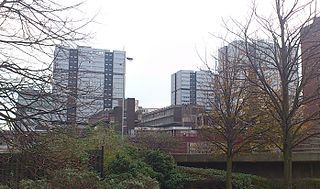
WThe Red Road Flats were a mid-twentieth-century high-rise housing complex located between the districts of Balornock and Barmulloch in the northeast of the city of Glasgow, Scotland. The estate originally consisted of eight multi-storey blocks of steel frame construction. All were demolished by 2015. Two were "slabs", much wider in cross-section than they are deep. Six were "points", more of a traditional tower block shape. The slabs had 28 floors, the point blocks 31, and taken together, they were designed for a population of 4,700 people. The point blocks were among the tallest buildings in Glasgow at 89 metres (292 ft), second in overall height behind the former Bluevale and Whitevale Towers in Camlachie. The 30th floor of the point blocks were the highest inhabitable floor level of any building in Glasgow.
 W
WThe Anderston Centre is a mixed-use commercial and residential complex, and former bus station located in the Anderston area of Glasgow, Scotland. Completed in 1972 and designed by Richard Seifert, it is one of the earliest examples of the "megastructure" style of urban renewal scheme fashionable in the 1950s and 1960s - the other notable example in Scotland being the infamous Cumbernauld Town Centre development. The complex is a notable landmark on the western edge of Glasgow city centre, and is highly visible from the adjacent Kingston Bridge.
 W
WArden is a medium-sized housing estate on the south-western edge of the city of Glasgow, Scotland. The M77 motorway runs directly to the west of the neighbourhood, with Junction 3 serving the area; a small industrial estate is located to the south-east. The residential area of Carnwadric is to the north-east of Arden, and the Jenny Lind part of Deaconsbank to the south, while the land to the north is open ground and woodland.
 W
WBarlanark is a district in the Scottish city of Glasgow. It is situated east of Budhill, Shettleston and Springboig, north west of Baillieston, west of Springhill and Swinton and south of Easthall, Easterhouse and Wellhouse.
WBarmulloch is a district in the Scottish city of Glasgow. It is situated north of the River Clyde. Formerly rural, it was developed as a post war overspill housing area, largely featuring Prefabricated housing. Barmulloch shares the Red Road complex of multi-storey flats with the neighbouring district of Balornock. Barmulloch is currently going through a huge change which includes demolition of tenement housing making way for new houses with driveways and private gardens. These developments are followed closely by Scottish charity Barmulloch Community Development Company who own the old Barmulloch Tenants Hall in Quarrywood Road and currently lease the former Church Hall in Quarrywood Avenue for local community functions and events.
WBlackhill is an area of north east Glasgow, Scotland. It is directly bordered by the M80 motorway to the west and the M8 motorway to the south. The neighbourhood falls within the North East ward under Glasgow City Council.
 W
WBogany Flats was a multi-storey block of flats in Castlemilk, Glasgow. The flats were built in 1966 by George Wimpey Ltd, the last of the nine tower blocks Whimpey built throughout the city in the sixties. The building was 20‐stories‐high and contained 114 dwellings, locally it was known as 'The Hilton'.
 W
WCadder is a council housing scheme in Glasgow, Scotland. Within the Canal ward under Glasgow City Council but historically more closely associated with the Maryhill district, it is located 4 kilometres (2 mi) north of Glasgow city centre, sited on the route of the Forth and Clyde Canal. Cadder was built in the early 1950s and contains Lambhill cemetery and crematorium, Western Necropolis and St. Kentigern's RC Cemetery.
 W
WCastlemilk is a district of Glasgow, Scotland. It lies to the far south of the city centre, adjacent to the Croftfoot and Simshill residential areas within the city to the north-west, the town of Rutherglen - neighbourhoods of Spittal to the north-east and Fernhill to the east, Linn Park and its golf course to the west, and the separate village of Carmunnock further south across countryside.
 W
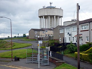
WCraigend is a neighbourhood in the Scottish city of Glasgow. It is situated north of the River Clyde, immediately west of Garthamlock, east of Hogganfield Park and Ruchazie and separated from Cranhill and Queenslie to the south by the M8 motorway. An area of open ground is to the north. The local landmarks are two water towers, which are illuminated at night.
WCranhill is an inner city district and housing scheme in the north east of Glasgow, Scotland. Cranhill was developed from public funding in the early 1950s and was originally, chiefly composed of four-storey tenement blocks surrounding a patch of grassland, which became Cranhill Park. Later development saw the building of three tower blocks, surrounded by rows of terraced maisonettes. In more recent years, a number of semi-detached and detached homes have been built. The area also hosts some shops, two primary schools and nurseries, a community centre and the Cranhill water tower.
 W
WDarnley is an area in south-west Glasgow, Scotland, on the A727 just west of Arden. Other nearby neighbourhoods are Priesthill to the north, Southpark Village to the south, and South Nitshill and Parkhouse to the west; there is also a small industrial estate. The closest railway station is Priesthill and Darnley. The Brock Burn flows through the area.
 W
WDrumchapel, known to locals and residents as 'The Drum', is part of the city of Glasgow, Scotland, having been annexed from Dunbartonshire in 1938. It borders Bearsden to the east and Clydebank to the west. The area is bordered by Knightswood and Yoker in Glasgow. The name derives from the Gaelic meaning 'the ridge of the horse'.
 W
WEasterhouse is a suburb of Glasgow, Scotland, located on the periphery of the city approximately 6 miles (10 km) east of its centre, partially built on land gained from the county of Lanarkshire as part of a boundary expansion of Glasgow prior to the Second World War. The area is on high ground north of the River Clyde and south of the River Kelvin and Campsie Fells.
 W
WEasthall is a residential neighbourhood in the East End of the Scottish city of Glasgow. Since 2007 it has been part of the Baillieston administrative ward within the Glasgow City Council area.
 W
WGarthamlock is a suburb in the north-east of the Scottish city of Glasgow. It is situated north of the River Clyde. Provanhall is the nearest neighbourhood to the east; Craigend is directly to the west with Hogganfield Park and Ruchazie beyond. Garthamlock is separated from Cranhill and Queenslie to the south by the M8 motorway. An area of open ground is to the north. The local landmarks are two water towers, which are illuminated at night.
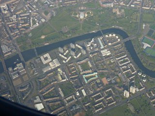
WThe Gorbals is an area in the city of Glasgow, Scotland, on the south bank of the River Clyde. By the late 19th century, it had become densely populated; rural migrants and immigrants were attracted by the new industries and employment opportunities of Glasgow. At its peak, during the 1930s, the wider Gorbals district had swollen in population to an estimated 90,000 residents. Along with its relatively small size, this gave the area a very high population density of around 40,000/km². Redevelopment post WWII has taken many turns, and the area's population is substantially smaller today.
WGreenfield is a neighbourhood in the east end of the Scottish city of Glasgow, north of the River Clyde. The estate was built on the grounds of Greenfield House which was demolished to make way for the new scheme which was built in the 1960s.
WHamiltonhill is a residential neighbourhood in the Scottish city of Glasgow, situated between Possilpark to the north and east and Port Dundas to the south. To the west of Hamiltonhill is a nature reserve bordering the Forth and Clyde Canal's Glasgow Branch section. The neighbourhood falls under the Canal ward of Glasgow City Council.
 W
WHutchesontown is an inner-city area in Glasgow, Scotland. Mostly residential, it is situated directly south of the River Clyde and forms part of the wider historic Gorbals district, which is covered by the Southside Central ward under Glasgow City Council.
 W
WKnightswood is a suburban district in Glasgow, containing three areas: Knightswood North or High Knightswood, Knightswood South or Low Knightswood, and Knightswood Park. It has a golf course and park, and good transport links with the rest of the city. Garscadden and Scotstounhill railway stations serve Low Knightswood while Westerton station serves High Knightswood. Knightswood is directly adjoined by the Anniesland, Blairdardie, Drumchapel, Garscadden, Jordanhill, Netherton, Scotstoun, Scotstounhill and Yoker areas of Glasgow, and by Bearsden in the north.
 W
WMilton is a district in the Scottish city of Glasgow, situated north of the River Clyde. The housing scheme is about 2.5 miles north of Glasgow City Centre and forms part of the northern edge of the city's urban area.
 W
WPenilee is a small housing scheme and suburb on the southwestern edge of Glasgow, Scotland. The area is bounded to its east by the Glasgow suburbs of Cardonald and Hillington, and to the west by the Renfrewshire border and the farms of North and South Arkleston. The district's southern boundary forms Glasgow's border with the Renfrewshire settlement of Ralston. The area is currently undergoing considerable residential redevelopment.
 W
WPollok is a large housing estate on the south-western side of the city of Glasgow, Scotland. The estate was built either side of World War II to house families from the overcrowded inner city. Housing 30,000 at its peak, its population has since declined due to the replacement of substandard housing with lower-density accommodation.
 W
WPossilpark is a district in the Scottish city of Glasgow, situated north of the River Clyde. The district's hub is Saracen Street. The area developed around Saracen Foundry of Walter MacFarlane & Co., which was the main employer. In the wake of the Saracen Foundry's closure in 1967, this section of Glasgow has become one of the poorest in the United Kingdom and crime rates are high. A variety of diverse community organisations operate in the area, providing arts, sports, health and gardening provision and community regeneration. These organisations include YPF, The Concrete Garden, Possobilities and Friends of Possilpark Greenspace. Possilpark is served by Possilpark & Parkhouse railway station on the Maryhill Line
WThe Red Road Flats were a mid-twentieth-century high-rise housing complex located between the districts of Balornock and Barmulloch in the northeast of the city of Glasgow, Scotland. The estate originally consisted of eight multi-storey blocks of steel frame construction. All were demolished by 2015. Two were "slabs", much wider in cross-section than they are deep. Six were "points", more of a traditional tower block shape. The slabs had 28 floors, the point blocks 31, and taken together, they were designed for a population of 4,700 people. The point blocks were among the tallest buildings in Glasgow at 89 metres (292 ft), second in overall height behind the former Bluevale and Whitevale Towers in Camlachie. The 30th floor of the point blocks were the highest inhabitable floor level of any building in Glasgow.
 W
WRiddrie is a north-eastern district of Glasgow, Scotland. It lies on the A80 Cumbernauld Road.
WRuchazie is a neighbourhood in the Scottish city of Glasgow. It is situated to the north-east of the city, bordered by Craigend and Garthamlock to the east and the open ground of Hogganfield Park and Lethamhill Golf Course to the north. Ruchazie is separated from Cranhill to the south and Riddrie to the west by the M8 motorway, previously the route of the Monkland Canal.
WSighthill is a neighbourhood in the Scottish city of Glasgow. It is situated north of the River Clyde and is part of the wider Springburn district in the north of the city. It is bordered to the north by Cowlairs, to the east by the Springburn Bypass road and the Royston neighbourhood, to the west by the Glasgow to Edinburgh via Falkirk Line and to the south by the Townhead interchange of the M8 Motorway.
 W
WSouth Nitshill is a neighbourhood in the Scottish city of Glasgow. It is situated south of the River Clyde, in the south-west of the conurbation and within the Greater Pollok ward of the local authority area. All streets in the area have names beginning with 'W'.
 W
WToryglen is a district in southern Glasgow, Scotland, falling within the Langside ward under Glasgow City Council. It is approximately two miles south of the city centre, bounded to the west by Mount Florida, the north-west by Polmadie, to the north-east by the West Coast Main Line railway and the M74 motorway the south by King's Park, and immediately to the east by the town of Rutherglen.
 W
WWellhouse is a residential neighbourhood in the East End of the Scottish city of Glasgow. Since 2007 it has been part of the Baillieston administrative ward within the Glasgow City Council area.
 W
WWyndford is an area of the city of Glasgow, Scotland. Located 2 miles northwest of the city centre in Maryhill, Wyndford is bounded by Maryhill Road to the north and the River Kelvin to the south. The area comprises council housing that is typical of that which was built throughout Glasgow in the 1960s and 1970s. The houses are now either privately owned or mainly run by Cube housing association. The community is represented by the Wyndford Tenants Union.