 W
WBatyieva Hora is a former village, and now a historical neighbourhood of Kyiv, the capital of Ukraine. It is located on the right bank of the Dnieper, on the side of the hill above the river Lybid. Burial grounds of Zarubintsy culture dated in the 2nd-4th century AD were discovered in Batyieva Hora.
 W
WBerezniaky is a historical neighbourhood, on the left bank of Kyiv, the capital of Ukraine. Massive construction began there in 1971.
 W
WBorshchahivka is a neighborhood located to the west and south-west of Kyiv, the capital of Ukraine. It is part of the city's Sviatoshynskyi District.
 W
WBortnychi is a historic neighbourhood in the southern part of Kyiv. Its southern and eastern boundaries are bordered with forests. Now Bortnychi is included in the Darnytsia Raion.
 W
WDemiivka is a neighborhood located in the Holosiiv Raion (district) of Kyiv, the capital of Ukraine. It is located towards the southern part of the city, in between the city's neighborhoods Chorna Hora, Shyrma, and Holosiiv National Park. Through the neighborhood flows Lybid River and the unofficial name of the neighborhood Nyzhnia Lybid. At its eastern edge is located a ridgeline of Kyiv Hills consisting of Lysa Hora, Chorna Hora, and Bahrynova Hora, past which is located Dnieper.
 W
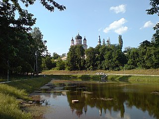
WFeofaniia or Teofaniia is a park located in the historical neighborhood on a tract near the southern outskirts of Kyiv, the capital of Ukraine. The neighborhood is located in the administrative Holosiiv Raion (district) amidst the neighborhoods of Holosiiv, Teremky, Pyrohiv and Khotiv. The park's total area is about 1.5 km2 (0.58 sq mi). The first Soviet computer, MESM, was built in Feofaniia.
 W
WThe Holosiivskyi National Nature Park Ukrainian: Націона́льний приро́дний парк «Голосі́ївський» is a protected remnant of forest surrounded by the urban area of the city of Kiev, Ukraine. It is located on the Kiev hills, in the Dniester-Dnieper forest-steppe province, North-Dnieper lowland and steppe zone of Left-Bank Dnieper province, in Holosiivskyi District. Its total area is 4525.52 hectares, of which 1879.43 hectares are in permanent use. It is managed by the Ministry of Ecology and Natural Resources of Ukraine.
 W
WHydropark, or Hidropark is a landscape-recreational park on the Dnieper River in Kyiv, Ukraine.
 W
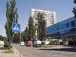
WKharkivskyi neighborhood, often referred to as Kharkivskyi masyv is located in the Darnytsia region of Kyiv, Ukraine. The area was first developed between the mid-1980s and early 1990s as an expansion of the Darnytsia neighborhood of the city. The name is rather symbolic than historic: it simply indicates that the area lies en route to the city of Kharkiv.
 W
WKlov is a historical neighbourhood in the Ukrainian capital Kyiv. Nowadays Klov is located in the administrative Pecherskyi District.
 W
WKoncha-Zaspa is a historic neighbourhood in the Holosiiv Raion (district) of the city of Kyiv, the capital of Ukraine. It is known for being the place where Ukraine's political elite live. Koncha-Zaspa is located in the southern part of the city. In the 1920s the territory was the first state preserve in the Ukrainian SSR.
 W
WKurenivka or Kurenyovka is a historical neighbourhood in Kyiv, the capital of Ukraine. It is located between the neighbourhoods of Podil, Obolon, Priorka, and Syrets.
 W
WLisovyi masyv is a neighbourhood located in the northeast part of the city of Kyiv, the capital of Ukraine. It is located next to the Bykivnia Forest and the residential neighborhood appeared in 1965-73, originally known as Vodopark.
 W
WLivoberezhnyi Masyv or commonly known as Livoberezhna is a residential neighborhood of the Ukrainian capital Kyiv. The neighborhood is administratively a part of the Dnipro Raion, and is located on the city's left bank.
 W
WLukyanivka is a historical neighborhood in the northwestern part of the city of Kyiv, the capital of Ukraine. It is situated on the right bank of Dnieper, at a short distance from Babi Yar.
 W
WNyvky is a neighbourhood in Kyiv, Ukraine. It belongs to Shevchenkivskyi District of Kyiv. It is surrounded by Svyatoshyn, Shuliavka, Vidradnyi, Syrets, Vynohradar, and Berkivtsi.
 W
WObolon is a historical locality which includes a residential area (masyv), along with an industrial park within the Ukraine's capital Kyiv that is located on its northern side, in an eponymous city district - the Obolonskyi District.
 W
WOld Kyiv or Old Kiev is a historical neighborhood of Kyiv. Other names include Upper City, Old Town, and others. It is located at the far eastern portion of the Shevchenko Raion. Old Kyiv historically represents the city of Yaroslav the Wise before it was presumably destroyed by the Mongol invasion of Batu Khan in 1240.
 W
WPechersk is a historical neighborhood in the city center of Kyiv, the capital of Ukraine. It is a part of the administrative Pechersk Raion (district). Pechersk is located between the Lypky, Klov and Dnieper hills. One of its main streets are the Ivan Mazepa Street, Dmytro Godzenko Street, Lesya Ukrainka Boulevard.
 W
WPetrivka is a neighborhood located in the Obolonskyi District (district) of Kyiv, the capital of Ukraine. It is located in the northern part of the city, neighboring the historical neighborhood of the Podil itself to its south.
 W
WPodil or Podol or the Lower city is a historic neighborhood in Kyiv, the capital of Ukraine. It is located on floodplain terrace over Dnieper between the Kyiv Hills and the lower stream of Pochaina River. Podil is one of the oldest neighborhoods of Kyiv, and the birthplace of the city's trade, commerce and industry. After the Mongol invasion of Rus' and destruction of Kyiv, it served as a city center until the 19th century. Here the city administration (magistrate) and the main university were located, and later the city's port and shipyard were established here.
 W
WPozniaky is a historical neighbourhood, on the left bank of Kyiv, the capital of Ukraine. Pozniaky metro station is situated in this neighborhood.
 W
WPushcha-Vodytsia is a historic neighbourhood, climate resort and an urban-type settlement (1981-2001) in the northwestern part of Kyiv. Located within a dense forest and away from the urban Kyiv, it is known for number of sanatoriums and state cottages for government officials such as presidents, prime-ministers etc.
 W
WPyrohiv, also known as Pirogov, originally a village south of Kyiv, is a neighborhood in the southern outskirts of the Ukrainian capital city. It is now home to an outdoor Museum of Folk Architecture and Life of Ukraine.
 W
WRusanivka is a man-made island and neighbourhood surrounded by a canal, the Rusanivs'kyi Kanal. The canal is an artificial distributary of the Dnieper River. The river and canal make the neighborhood resemble an island. The island is located in the left-bank part of Kyiv, the capital of Ukraine. It is surrounded by such neighborhoods like Hidropark, Darnytsia, Berezniaky, and Livoberezhnyi masyv.
 W
WRybalskyi Island is a misnomer for an actual peninsula on the Dnieper River, located in the right-bank Podil neighborhood and Kyiv Harbour of the city of Kyiv. Although named as an island it is in fact a peninsula and a former spit serving as a left-bank of a former Pochaina River that with time transformed into several oxbow lakes located in Obolon. The peninsula is now a predominantly industrial area.
WSviatoshyn is a historical neighborhood and a suburb of Ukraine's capital Kyiv that is located on the western edge of the city area, in an eponymous municipality.
 W
WTeremky is a neighborhood located in the Holosiiv Raion (district) of Kyiv, the capital of Ukraine. It is located in the southern part of the city, in between the city's Holosiiv, Feofaniya, and Zhuliany neighborhoods.
 W
WTroieshchyna or since 1987 Vyhurivschyna-Troieshchyna is a large neighborhood of Kyiv, the capital of Ukraine. Troieshchyna is an outskirt located on the city's northern left-bank and is administratively part of the Desnianskyi District.
 W
WVidradnyi is a neighbourhood in Kyiv, Ukraine. It belongs to Solomianskyi Raion (district) of Kyiv.
 W
WVoskresenka is a district of Kyiv, the capital of Ukraine, and is a historical region on the left bank of the river Dnipro.
 W
WVynohradar is a historical neighbourhood in the Ukrainian capital Kyiv. Vynohradar is now located in the administrative Shevchenkivskyi District and Podilskyi Raion (district). Main roads in the area include the Prospekts Pravdy, Svobody and Georgiy Gongadze.
 W
WZhuliany is a neighbourhood in the south-west of Kyiv, the capital of Ukraine. It is a predominantly cottage-built area, part of the Solomianskyi district. As well as Troieshchyna, Zhuliany became a part of Kyiv municipality in 1988.