 W
WThe territory of Cape Verde is divided into 22 concelhos (municipalities), and subdivided into 32 freguesias.
WThe territory of Cape Verde is divided into 22 concelhos (municipalities), and subdivided into 32 freguesias.
 W
WFreguesia, usually translated as "parish" or "civil parish", is the third-level administrative subdivision of Portugal, as defined by the 1976 Constitution. It is also the designation for local government jurisdictions in the former Portuguese overseas territories of Cape Verde and Macau. In the past, was also an administrative division of the other Portuguese overseas territories. The parroquia in the Spanish autonomous communities of Galicia and Asturias is similar to a freguesia.
 W
WMosteiros is a concelho (municipality) of Cape Verde. Situated in the northeastern part of the island of Fogo, it covers 19% of the island area, and is home to 26% of its population. Its seat is the city Mosteiros (Igreja). Its population was 9,524 at the 2010 census, and its area is 89.45 km2.
 W
WNossa Senhora da Conceição is a freguesia of Cape Verde. It covers the southern part of the municipality of São Filipe, on the island of Fogo. The freguesia consists of the following settlements:
 W
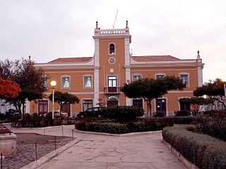
WPraia is a concelho (municipality) of Cape Verde. It is situated in the southern part of the island of Santiago. Its seat is the city Praia, the capital of Cape Verde. Its area is 120.6 km2 (46.6 sq mi), and its population was 131,719 at the 2010 census. The municipality consists of one freguesia, Nossa Senhora da Graça. The city hall is located in the Platô part of the city.
 W
WNossa Senhora da Lapa is a freguesia of Cape Verde. It covers the smaller northwestern part of the municipality of Ribeira Brava, on the island of São Nicolau.
 W
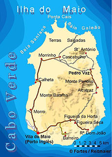
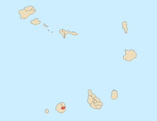
WMaio is the easternmost of the Sotavento islands of Cape Verde. Maio is located south of the island of Boa Vista and east of Santiago. Administratively, the island forms one concelho (municipality): Maio.
WNossa Senhora da Luz is a freguesia of Cape Verde. It covers the eastern part of the municipality of São Domingos, on the island of Santiago.
 W
WSal is an island in Cape Verde. Sal is a tourist destination with white sandy beaches and over 350 days of sunshine a year. It is one of the three sandy eastern islands of the Cape Verde archipelago in the central Atlantic Ocean, 350 mi (560 km) off the west coast of Africa. Cabo Verde is known for year-round kiteboarding, for the large reserve of Caretta turtles which hatch from July to September, and the music of Cesaria Evora.
 W
WNossa Senhora do Livramento is a freguesia of Cape Verde. It covers the northern part of the municipality of Ribeira Grande, on the island of Santo Antão.
WNossa Senhora do Monte is a freguesia of Cape Verde. It covers the western part of the island of Brava. To its east is the parish of São João Baptista.
WNossa Senhora do Rosário is a freguesia of Cape Verde. It covers the larger eastern part of the municipality of Ribeira Brava, on the island of São Nicolau.
WNossa Senhora do Rosário is a freguesia of Cape Verde. It covers the eastern part of the municipality of Ribeira Grande, on the island of Santo Antão.
 W
WSanta Catarina is a concelho (municipality) of Cape Verde. It is situated in the western part of the island of Santiago. Its seat is the city of Assomada. Its population was 45,920 in 2017 (estimate). Its area is 242.6 km2 (93.7 sq mi).
 W
WSanta Catarina do Fogo is a concelho (municipality) of Cape Verde. Situated in the southeastern part of the island of Fogo, it covers 32% of the island area, and is home to 14% of its population. Its seat is the city Cova Figueira. The Municipality of Santa Catarina do Fogo was created in 2005; before 2005, it was a parish of the Municipality of São Filipe.
WSanta Isabel is a freguesia of Cape Verde. It covers the western part of the island of Boa Vista, and contains the island's capital Sal Rei. The freguesia consists of the following settlements:Bofarreira Estância de Baixo Povoação Velha Rabil (town) Sal Rei (city)
 W
WSanta Cruz is a concelho (municipality) of Cape Verde. It is situated in the eastern part of the island of Santiago. Its seat is the city Pedra Badejo. Its population was 26,617 at the 2010 census, and its area is 112.2 km2.
WSantíssimo Nome de Jesus is a freguesia of Cape Verde. It covers the eastern part of the municipality of Ribeira Grande de Santiago, on the island of Santiago.
 W
WTarrafal is a concelho (municipality) of Cape Verde. It is situated in the northern part of the island of Santiago. Its seat is the town Tarrafal. Its population was 18,565 at the 2010 census, and its area is 120.8 km2.
WSanto André is a freguesia of Cape Verde. It covers the smaller, northwestern part of the municipality of Porto Novo, on the island of Santo Antão.
 W
WPaul is a concelho (municipality) of Cape Verde. Situated in the northeastern part of the island of Santo Antão, it covers 7% of the island area, and is home to 16% of its population. Its seat is the town Pombas.
WSanto Crucifixo is a freguesia of Cape Verde. It covers the southern part of the municipality of Ribeira Grande, on the island of Santo Antão. The seat of the parish is Coculi. The parish covers much of the Ribeira Grande valley.
WSão João Baptista is a freguesia of Cape Verde. It covers the eastern part of the island of Brava. The parish seat is Nova Sintra. To its west is the parish of Nossa Senhora do Monte.
WSão João Baptista is a freguesia of Cape Verde. It covers the eastern part of the island of Boa Vista. It is named after the church located in Fundo das Figueiras.
WSão João Baptista is a freguesia of Cape Verde. It covers the western part of the municipality of Ribeira Grande de Santiago, on the island of Santiago.
WSão João Baptista is a freguesia of Cape Verde. It covers the larger, southern part of the municipality of Porto Novo, on the island of Santo Antão.
WSão Lourenço is a freguesia of Cape Verde. It covers the northern part of the municipality of São Filipe, on the island of Fogo. The parish has an area of 96 km². It is also a religious parish, its religious celebration is on August 10, day of Saint Lawrence.
 W
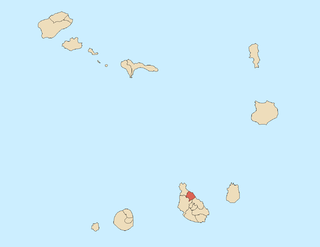
WSão Lourenço dos Órgãos is a concelho (municipality) of Cape Verde. It is situated in the mountainous central part of the island of Santiago. Its seat is the city João Teves. Its population was 7,388 at the 2010 census, and its area is 36.9 km2. The municipality is bordered by Santa Cruz to the northeast, São Domingos to the south, Ribeira Grande de Santiago to the southwest and São Salvador do Mundo to the northwest. Pico de Antónia, the island's highest mountain, straddles the borders of São Lourenço dos Órgãos, São Salvador do Mundo and Ribeira Grande de Santiago.
 W
WSão Miguel is a concelho (municipality) of Cape Verde. It is situated in the northeastern part of the island of Santiago. Its seat is the city Calheta de São Miguel. Its population was 15,648 at the 2010 census, and its area is 77.4 km2. The municipality was created in 1996, when a parish of the older Municipality of Tarrafal was separated to become the Municipality of São Miguel.
 W
WSão Nicolau Tolentino is a freguesia of Cape Verde. It covers the western part of the municipality of São Domingos, on the island of Santiago.
WSão Pedro Apóstolo is a freguesia of Cape Verde. It covers the western part of the municipality of Ribeira Grande, on the island of Santo Antão.
 W
WSão Salvador do Mundo is a concelho (municipality) of Cape Verde. It is situated in the central part of the island of Santiago. Its seat is the city Picos. Its population was 8,677 at the 2010 census, and its area is 26.5 km2, making it the smallest municipality of Cape Verde. The municipality borders Santa Cruz to the northeast, São Lourenço dos Órgãos to the southeast, Ribeira Grande de Santiago to the southwest and Santa Catarina to the northwest.