 W
WAlexandria Carmania was one of the seventy-plus cities founded or renamed by Alexander the Great.
 W
WAnshan, modern Tall-e Malyan, was an ancient city in Iran. It was located in the Zagros Mountains in southwestern Iran, approximately 46 kilometres (29 mi) north of Shiraz and 43 kilometres (27 mi) west of Persepolis in the Beyza/Ramjerd plain, in the province of Fars. Its location serves as a landmark for Elamite studies.
 W
WBābā Jān Tepe (Tappa), an archeological site in north-eastern Lorestan Province, on the southern edge of the Delfān plain at approximately 10 km from Nūrābād, important primarily for excavations of first-millennium B.C. levels conducted by C. Goff from 1966-69. Work concentrated on two mounds joined by a saddle. The East Mound yielded a series of first-millennium B.C. buildings above Bronze Age graves. On the Central Mound, excavation concentrated on the Baba Jan III Manor on the summit; an 8 x 6 m Deep Sounding provides a partial late fourth- to mid-second-millennium B.C. sequence
 W
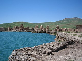
WBishapur was an ancient city in Sasanid Persia (Iran) on the ancient road between Persis and Elam. The road linked the Sassanid capitals Estakhr and Ctesiphon. It is located south of modern Faliyan in the Kazerun County of Pars Province, Iran.
 W
WChapalak Cave is a Late Paleolithic site located at the Amarlou region, in the Gilan Province, northern Iran. The cave contains evidence for late Paleolithic human cave occupation. Stone artifacts and animal remains were excavated by an Iranian-Korean team in 2008. They found lithic artifacts in the upper most layer of the test pit that based on their techno-typological characteristics attributed to the Late Paleolithic period.
 W
WChia Jani is an archaeological site in Iran, located along the Qouchemi stream, which flows to the Ravand River about 3 km (1.9 mi) south, in south central part of the Islamabad Plain in the Central-West Zagros Mountains.
 W
WDarband Cave is a Lower Paleolithic site in the Gilan Province in northern Iran, located on the north side of a deep tributary canyon of the Siahrud River, a tributary of the Sefīd-Rūd River that flows into the Caspian Sea.
 W
WEcbatana was an ancient city in Media in western Iran. It is believed that Ecbatana is in Hagmatana Hill, an archaeological mound in Hamedan.
WEshkaft-e Siahoo, that translates to "Black Cave" from the regional dialect, was used by Neolithic humans as a rock shelter between 12,000 to 10,000-years ago. It is located near Rahmat Mountain on the Marvdasht Plain in the Fars province, Iran. The cave was discovered in June 2006 and archaeological excavations were subsequently undertaken, led by Iranian archeologist Mohammad Feizkhah.
 W
WGanzak, is an ancient town founded in northwestern Iran. The city stood somewhere south of Lake Urmia, and it has been postulated that the Persian nobleman Atropates chose the city as his capital. The exact location, according to Minorsky, Schippmann, and Boyce, is identified as being the ruins at Leylan, Malekan County in the Miandoab plain.
 W
WGeoy Tepe is an archaeological site in northwestern Iran, about 7 kilometers south of Urmia (Reżāʾīya). It was found by an aerial survey of ancient sites in Persia done by Erich Schmidt in the 1930s.
 W
WGodin Tepe is an archaeological site in western Iran, situated in the valley of Kangavar in Kermanshah Province. Discovered in 1961, the site was excavated from 1965 to 1973 by a Canadian expedition headed by T. Cuyler Young Jr. and sponsored by the Royal Ontario Museum. The importance of the site may have been due to its role as a trading outpost in the early Mesopotamian trade networks.
 W
WHaft Tepe is an archaeological site situated in the Khuzestan Province in south-western Iran. At this site the remains of the Elamite city of Kabnak were discovered in 1908, and excavations are still carried out.
 W
WHajji Firuz Tepe is an archaeological site located in West Azarbaijan province in north-western Iran and lies in the north-western part of the Zagros Mountains. The site was excavated between 1958 and 1968 by archaeologists from the University of Pennsylvania Museum of Archaeology and Anthropology. The excavations revealed a Neolithic village that was occupied in the second half of the sixth millennium BC where some of the oldest archaeological evidence of grape-based wine was discovered in the form of organic residue in a pottery jar.
 W
WHilleh Historical Village is a special sub-ground historical village in Osku County, Iran near to Osku in the vicinity of Kandovan, Osku. Currently nobody lives there. It is claimed it was built before the Islamic period. It was destroyed during Mongol attack on Iran. The entire houses remain. Different parts of the houses like kitchens, and special places for animals inside the houses can be seen.
 W
WKonar Sandal is a Bronze Age archaeological site, situated just south of Jiroft, Kermān Province, Iran.
 W
WLiyan is an Elamite port on Persian Gulf, and first name of Kiririsha where she and Humban had a temple that was erected by Humban-Numena. There was later a temple built to her at Chogha Zanbil. She was often called 'the Great', or 'the divine mother'. She seems to have been primarily worshipped in the south of Elam, as another goddess, Pinikir, held her position in the north. Eventually, by about 1800 BC, the two had merged and the cult of Kiririsha also came to be practised in Susiana.
 W
WMount Khwaja or Mount Khwajeh is a flat-topped black basalt hill rising up as an island in the middle of Lake Hamun, in the Iranian province of Sistan and Baluchestan.
 W
WMuṣaṣir Assyrian KURMu-ṣa-ṣir and variants, including Mutsatsir, Akkadian for Exit of the Serpent/Snake ), in Urartian Ardini was an ancient city of Urartu, attested in Assyrian sources of the 9th and 8th centuries BC.
 W
WPasargadae was the capital of the Achaemenid Empire under Cyrus the Great, who ordered its construction. Today it is an archaeological site and one of Iran's UNESCO World Heritage Sites, about 90 kilometres (56 mi) to the northeast of the modern city of Shiraz. A limestone tomb there is believed to be that of Cyrus the Great.
 W
WQaleh Bozi is a complex of caves sites located about 25 km (15.5 mi) south-southwest of Isfahan, Iran; northeast of Dizicheh and north of Hassanabad. The sites include two rock shelters and a cave located at altitudes between 1,750 and 1,810 m above sea level. The caves are found on the southern face of a limestone mountain of lower Cretaceous age that rises to more than 500 m (1,640.4 ft) above the plain floor. From the cave entrance there is a commanding view of the plain below and of the Zaiandeh Rud River flowing about 2 km (1.2 mi) to the south and southeast.
WQumis, also known as Hecatompylos was an ancient city which was the capital of the Arsacid dynasty by 200 BCE. The Greek name Hekatompylos means "one hundred gates" and the Persian term has the same meaning. The title was commonly used for cities which had more than the traditional four gates. It may be understood better as the "Many Gated". Most scholars locate it at Sahr -e Qumis, in the Qumis region in west Khurasan, Iran.
 W
WThe Rahmatabad Mound or the Rahmatabad Tepe is one of the most historically significant settlements on the Marvdasht plain, Persia (Iran) measuring 115 m in length and 75 m in width and 4.5 m in height. The mound sits at the edge of the fertile Kamin plain at the southerly end of the Bolaghi gorge.
WSeleucia-on-the-Hedyphon was an ancient city on the Hedyphon river in Susiana, east of Mesopotamia, currently the site of Ja Nishin, Khuzestan Province, Iran.
WShahr-e Sukhteh, also spelled as Shahr-e Sūkhté and Shahr-i Sōkhta, is an archaeological site of a sizable Bronze Age urban settlement, associated with the Jiroft culture. It is located in Sistan and Baluchistan Province, the southeastern part of Iran, on the bank of the Helmand River, near the Zahedan-Zabol road. It was placed on the UNESCO World Heritage List in June 2014.
 W
WShiwatoo, located 7 km to the west of Mahabad, overlooking Mahabad-Piranshahr road in the West Azarbaijan Province, Iran, is an archaeological site of the Lower Paleolithic, c. 400.000 years ago. Archaeologists collected nearly one hundred artifacts from an area measuring about one hectare overlooking the Mahabad River. Many of the artifacts were made from andesite, quartzite, and basalt cobbles. The stone industry consists primarily of cores, tested cobbles, and core-choppers. The most characteristic find from this site is a Cleaver (tool), which is a type of biface stone tool of Acheulean tradition of the Lower Palaeolithic.
 W
WTakht-e Soleymān, is an archaeological site in West Azerbaijan, Iran from Sasanian Empire. It lies midway between Urmia and Hamadan, very near the present-day town of Takab, and 400 km (250 mi) west of Tehran.
 W
WTepe Giyan, also Tepe Gyan, is an archaeological site in the highland central Zagros mountain, in the area later known as Persia. It is mainly known for a necropolis of 19 graves. It is bears similarities with the site of Tepe Sialk, in the same general area, and its oldest ceramics are also related to the Ubaid period in Mesopotamia.
 W
WTepe Hissar is a prehistoric site located in the village Heydarabad just south of Damghan in Semnan Province in Northeastern Iran. The site was firstly discovered in 1877 by Albert Houtum-Schindler and then investigated in 1931 and 1932 by Erich Schmidt, on behalf of the University of Pennsylvania Museum. A surface survey was carried out in 1972, while in 1976 a re-study project was performed, utilizing modern methods of stratigraphic assessments, ceramic typological analysis and radiocarbon dating, by the University of Pennsylvania Museum, the University of Turin and Iran Center for Archaeological Research(Dyson and Howard, 1989). Other researches, rescue excavations and salvage works were done in the 1990s.
WTepe Sialk is a large ancient archeological site in a suburb of the city of Kashan, Isfahan Province, in central Iran, close to Fin Garden. The culture that inhabited this area has been linked to the Zayandeh River Culture.
WTapeh Yahya is an archaeological site in Kermān Province, Iran, some 220 kilometres (140 mi) south of Kerman city, 90 kilometres (56 mi) south of Baft city and 90 km south-west of Jiroft.
 W
WTeppe Hasanlu or Tappeh Hassanlu is an archeological site of an ancient city located in northwest Iran, a short distance south of Lake Urmia. The nature of its destruction at the end of the 9th century BC essentially froze one layer of the city in time, providing researchers with extremely well preserved buildings, artifacts, and skeletal remains from the victims and enemy combatants of the attack.
WUrua, Uruaz or Avva was an ancient city of Elam, in the vicinity of Susa and located on the Uqnu river.
WWarwasi is a Paleolithic rockshelter site located at north of Kermanshah in western Iran. It was excavated by Bruce Howe under direction of late Robert Braidwood in the 1960s. This site contains a rich archaeological sequence from Middle Paleolithic to late Epipaleolithic.