 W
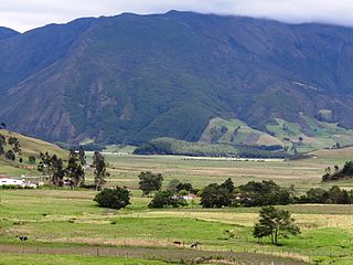
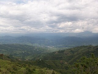
WThe Altiplano Cundiboyacense [altiˈplano kundiβoʝaˈsense] is a high plateau located in the Eastern Cordillera of the Colombian Andes covering parts of the departments of Cundinamarca and Boyacá. The altiplano corresponds to the ancient territory of the Muisca. The Altiplano Cundiboyacense comprises three distinctive flat regions; the Bogotá savanna, the valleys of Ubaté and Chiquinquirá, and the valleys of Duitama and Sogamoso. The average altitude of the altiplano is about 2,600 metres (8,500 ft) above sea level but ranges from roughly 2,500 metres (8,200 ft) to 4,000 metres (13,000 ft).
 W
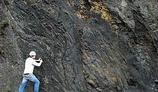
WThe Arcabuco Formation is a geological formation of the Altiplano Cundiboyacense, Eastern Ranges of the Colombian Andes. The formation consists of thick beds of light-coloured quartzitic sandstones and conglomerates with occasional shales and dates to the Late Jurassic and Early Cretaceous periods; Tithonian to Berriasian epochs. Dinosaur footprints have been found in the Arcabuco Formation near the Iguaque anticlinal outside Chíquiza, Boyacá.
 W
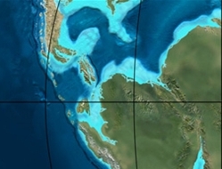
WThe Llanos Basin or Eastern Llanos Basin is a major sedimentary basin of 96,000 square kilometres (37,000 sq mi) in northeastern Colombia. The onshore foreland on Mesozoic rift basin covers the departments of Arauca, Casanare and Meta and parts of eastern Boyacá and Cundinamarca, western Guainía, northern Guaviare and southeasternmost Norte de Santander. The northern boundary is formed by the border with Venezuela, where the basin grades into the Barinas-Apure Basin.
 W
WBoyacá State was one of the states of Colombia.
 W
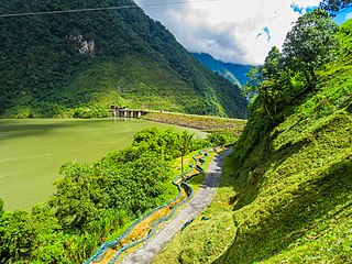
WThe Chicamocha Canyon is a steep sided canyon carved by the Chicamocha River in Colombia. With a maximum depth of 2,000 metres (6,600 ft), an area of 108,000 hectares and a length of 227 kilometres (141 mi), the canyon is the second-largest worldwide. The canyon is situated in the departments of Boyacá and Santander, stretching from Soatá in the southeast to Girón and Betulia in the northwest.
 W
WEl Cocuy National Park is a national park located in the Andes Mountains within the nation of Colombia. Its official name is Parque Nacional Natural El Cocuy.
 W
WThe Cuche Formation is a geological formation of the Floresta Massif, Altiplano Cundiboyacense in the Eastern Ranges of the Colombian Andes. The sequence of siltstones, shales, and sandstone beds dates to the Late Devonian and Early Carboniferous periods, and has a maximum thickness of 900 metres (3,000 ft).
 W
WThe Eastern Frontal Fault System is a megaregional system of oblique and thrust faults cross-cutting Colombia from Ecuador in the south to Venezuela in the north. The system from south to north covers ten out of 32 departments of Colombia; Nariño, Putumayo, Cauca, Huila, Caquetá, Cundinamarca, Meta, Boyacá, Casanare and Arauca. The Eastern Frontal Fault System underlies and affects the capitals of Putumayo, Mocoa, Caquetá, Florencia, Meta, Villavicencio and Casanare, Yopal. The fault system has a total length of 921.4 kilometres (572.5 mi) with a cumulative length of the faults of 1,821.8 kilometres (1,132.0 mi) and runs along an average northeast to southwest strike of 042.1 ± 19 bordering and crossing the Eastern Ranges of the Colombian Andes. The fault system forms the boundary between the North Andes microplate and the South American Plate.
 W
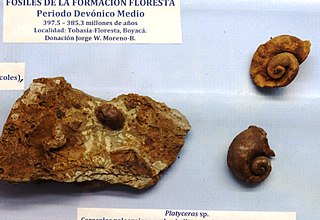
WThe Floresta Formation is a geological formation of the Altiplano Cundiboyacense in the Eastern Ranges of the Colombian Andes. The sequence of siltstones, shales, coquinas and sandstone beds dates to the Devonian period; Late Emsian, Eifelian and Early Givetian epochs, and has a maximum thickness of 600 metres (2,000 ft). The unit is highly fossiliferous; brachiopods, bryozoans, gastropods, trilobites, corals and bivalves have been found in the Floresta Formation. Some fragments of Placoderm fish fossils were found in the Floresta Formation, while the overlying Cuche Formation is much richer in fish biodiversity.
 W
WThe Fómeque Formation is a geological formation of the Altiplano Cundiboyacense, Eastern Ranges of the Colombian Andes. The predominantly organic shale formation dates to the Early Cretaceous period; Barremian to Late Aptian epochs and has a maximum thickness of 1,200 metres (3,900 ft).
 W
WThe Chipaque Formation (Spanish: Formación Chipaque, K2cp, Kc) is a geological formation of the Altiplano Cundiboyacense, Eastern Ranges of the Colombian Andes. The formation is also described as Gachetá Formation, named after Gachetá, in the area of the Llanos foothills of the Eastern Ranges. The predominantly organic shale formation dates to the Late Cretaceous period; Cenomanian-Turonian epochs and has a maximum thickness of 1,700 metres (5,600 ft). The formation, rich in TOC, is an important oil and gas generating unit for the giant oilfields Cupiagua and Cusiana of the Eastern Ranges as well as in the Llanos Orientales.
WThe Conejo Formation (Spanish: Formación Conejo, K2C, Kscn) is a fossiliferous geological formation of the Altiplano Cundiboyacense, Eastern Ranges of the Colombian Andes. The uppermost unit of the Villeta Group, a sequence of shales and sandstones dates to the Late Cretaceous period; Turonian, Coniacian and Santonian epochs, and has a maximum thickness of 1,022 metres (3,353 ft).
 W
WThe Girón Formation is an extensive geological formation stretching across 325 kilometres (202 mi) from the north in Teorama, Norte de Santander, across the Mesa de Los Santos and Chicamocha Canyon towards west of Nobsa, Boyacá in the northern part of the Altiplano Cundiboyacense in the south. The formation extends across the northern and central part of the Eastern Ranges of the Colombian Andes.
 W
WThe Macanal Formation or Macanal Shale is a fossiliferous geological formation of the Altiplano Cundiboyacense and Tenza Valley in the Eastern Ranges of the Colombian Andes. The predominantly organic shale formation dates to the Early Cretaceous period; Berriasian to Valanginian epochs and has a maximum thickness of 2,935 metres (9,629 ft). The Macanal Formation contains numerous levels of fossiliferous abundances. Bivalves, ammonites and fossil flora have been found in the formation.
WThe Oliní Group (Spanish: Grupo Oliní, K3k5o, K2ol, Kso) is a fossiliferous geological group of the VMM, VSM and the eastern flanks of the Central and western flanks of the Eastern Ranges of the Colombian Andes. The regional group stretches from north to south across approximately 700 kilometres (430 mi) and dates to the Late Cretaceous period; Coniacian, Santonian and Campanian epochs, and has a maximum thickness of 287 metres (942 ft). Fossils of Eonatator coellensis have been found in the unit, near Coello, Tolima.
 W
WThe Paja Formation is an Early Cretaceous geologic formation of central Colombia. The formation extends across the northern part of the Altiplano Cundiboyacense, the Western Colombian emerald belt and surrounding areas of the Eastern Ranges of the Colombian Andes. In the subsurface, the formation is found in the Middle Magdalena Valley to the west. The Paja Formation stretches across four departments, from north to south the southernmost Bolívar Department, in Santander, Boyacá and the northern part of Cundinamarca. Well known fossiliferous outcrops of the formation occur near Villa de Leyva, also written as Villa de Leiva, and neighboring Sáchica.
 W
WThe Villeta Group is a geological group of the Eastern Ranges of the Colombian Andes, to the west of the Altiplano Cundiboyacense. The group, a sequence of shales, limestones and sandstones, is subdivided into various formations; Conejo, La Frontera, Simijaca, Hiló, Pacho, Chiquinquirá, Capotes, Socotá, El Peñón, and Trincheras, and dates to the Cretaceous period; Aptian-Coniacian epochs. The group stretches out across four departments, from Huila in the south, through Cundinamarca and Boyacá to southern Santander in the north. The upper part of the Villeta Group is time-equivalent with the La Luna Formation of the Middle Magdalena Valley (VMM) and Sierra Nevada del Cocuy, the Oliní and Güagüaquí Groups of the Guaduas-Vélez synclinal and the Chipaque Formation of the Altiplano Cundiboyacense. The lower part has been correlated with the Simití, Tablazo and Paja Formations of the VMM, the upper Tibasosa, Une and Fómeque Formations of the Altiplano Cundiboyacense and the Capacho, Aguardiente, Tibú-Mercedes and upper Río Negro Formations of the Sierra Nevada del Cocuy.
WThe La Frontera Formation (Spanish: Formación La Frontera, K2F, Ksf) is a geological formation, part of the Villeta Group, of the Altiplano Cundiboyacense and neighbouring areas of the Eastern Ranges of the Colombian Andes. The sequence of limestones and lydites dates to the Late Cretaceous period; Turonian epoch and has a maximum thickness of 206 metres (676 ft).
WThe Guavio Formation is a geological formation of the Altiplano Cundiboyacense, Eastern Ranges of the Colombian Andes. The formation consists of conglomerates, shales and limestones, dates to the Late Jurassic and Early Cretaceous periods; Tithonian to Berriasian epochs and has a maximum thickness of 1,000 metres (3,300 ft).
 W
WLake Iguaque is a lake located in the Boyacá Department of Colombia. The lake and the surrounding area was declared a Flora and Fauna Sanctuary in 1977.
 W
WThe Middle Magdalena Valley, Middle Magdalena Basin or Middle Magdalena Valley Basin is an intermontane basin, located in north-central Colombia between the Central and Eastern Ranges of the Andes. The basin, covering an area of 34,000 square kilometres (13,000 sq mi), is situated in the departments of Santander, Boyacá, Cundinamarca and Tolima.
 W
WThe Ocetá Páramo is a páramo at altitudes between 2,950 metres (9,680 ft) and 3,950 metres (12,960 ft) in the Eastern Ranges of the Colombian Andes. It covers parts of the municipalities Monguí, Mongua and Tópaga, belonging to the Sugamuxi Province, Boyacá. The Ocetá Páramo is known for its collection of frailejones and other flora, as well as Andean fauna. Hiking tours from Monguí or Mongua to the páramo take a full day.
 W
WThe Paipa–Iza volcanic complex is a volcanic field of Late Pliocene to Early Pleistocene age on the Altiplano Cundiboyacense in the Eastern Ranges of the Colombian Andes. It is the northernmost volcanic complex of the Andean Volcanic Belt with Fueguino in Tierra del Fuego, Chile, at the opposite end of the Andean mountain belt.
 W
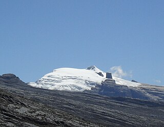
WRitacuba Blanco is the highest peak of Cordillera Oriental, in the Andes Mountains of Colombia. It's also named Ritak'uwa, an ancient name from the U'wa indigenous people that live in the lowlands of the National Park Sierra Nevada del Cocuy y Güicán, where the Ritacuba Blanco is located. The summit is accessible from the west via the town of El Cocuy, the village of Güicán and the hamlet of Las Cabañas. The hike is fairly easy, but weather is not reliable, and a glacier must be crossed. Because of global warming, its glacier is melting at very high rates, backing down 25 linear mts per year; same is happening at amazing speeds to all other snow-covered tropical mountains in Colombia. In 1950, Ritacuba Blanco's glacier extended down to 4,500 metres (14,800 ft) above sea level; in January 2007 its lowest point was at 4,800 metres (15,700 ft) above sea level. If this melting rate continues, the glacier is expected to disappear before 2025.
 W
WChicamocha River is a river of Boyacá and Santander in north-central Colombia. It is part of the Magdalena river system that flows into the Caribbean Sea.
 W
WThe Santa Rosa de Viterbo Meteorite was found in 1810, in the Tocavita Hill, near the town that holds the same name in the north central area of Boyacá, Colombia.
 W
WThe Sierra Nevada del Cocuy Chita o Guican National Natural Park (or Sierra Nevada de Chita or Sierra Nevada de Güicán, Spanish: Parque Natural Sierra Nevada del Cocuy Chita o Guican is a national park and a series of highlands and glaciated peaks located within the Cordillera Oriental mountain range in the Andes Mountains of Colombia, at its easternmost point. It also corresponds to the highest range of the Eastern Cordillera and holds the biggest glacial mass in South America, North of the Equator. Since 1977, this region is protected within a National Natural Park because of its fragile páramos, extraordinary bio-diversity and endemism, and its function as a corridor for migratory species under conditions of climate change. Among the Sierra’s natural attractions are the remaining 18 ice-covered peaks, glacial lakes and waterfalls.
WThe Simijaca Formation (Spanish: Formación Simijaca, K2S, Kss) is a geological formation of the Altiplano Cundiboyacense, Eastern Ranges of the Colombian Andes. The predominantly mudstone formation dates to the Late Cretaceous period; Turonian and Cenomanian epochs, and has a maximum thickness of 693 metres (2,274 ft).
 W
WThe Soatá Formation is a geological formation of the northern Altiplano Cundiboyacense, Eastern Ranges of the Colombian Andes. The formation consists mainly of shales with conglomerates and dates to the Quaternary period; Late Pleistocene epoch. The heavily eroded formation has a maximum measured thickness of 30.8 metres (101 ft). It contains the lacustrine and fluvio-glacial sediments of elongated paleolake Soatá, that existed on the Altiplano in the valley of the Chicamocha River.
 W
WThe Suárez River, originally Saravita, is a river in the Eastern Ranges of the Colombian Andes. The river originates in Lake Fúquene on the border of Cundinamarca and Boyacá and its mouth is the confluence with the Chicamocha River, forming the Sogamoso River in Santander. It is part of the Magdalena Basin flowing towards the Caribbean Sea.
 W
WThe Tenza Valley is an intermontane valley in the Eastern Ranges of the Colombian Andes. The valley stretches over the southeastern part of the department of Boyacá and the northeastern part of Cundinamarca. It is located east of the Altiplano Cundiboyacense and in the time before the Spanish conquest of the Muisca, as the Altiplano was inhabited by the Muisca in the higher altitudes and the Tegua in the lower areas to the east.
 W
WThe Chibcha Terrane, named after Chibcha, is the largest of the geological provinces (terranes) of Colombia. The terrane, the oldest explored domains of which date to the Meso- to Neoproterozoic, is situated on the North Andes Plate. The megaregional Romeral Fault System forms the contact of the terrane with the Tahamí Terrane. The contact with the Caribbean and La Guajira Terranes is formed by the regional Bucaramanga-Santa Marta Fault. The northeastern boundary is formed by the regional Oca Fault, bounding the La Guajira Terrane. The terrane is emplaced over the Río Negro-Juruena Province of the Amazonian Craton along the megaregional Eastern Frontal Fault System.
 W
WLake Tota, the largest lake in Colombia, located in the east of Boyacá department, inside the Sugamuxi Province, it is the source of the Upia River which flows into the Orinoco River basin.
 W
WThe Une Formation is a geological formation of the Altiplano Cundiboyacense, Eastern Ranges of the Colombian Andes. The predominantly sandstone formation dates to the Middle Cretaceous period; Albian to Cenomanian epochs and has a maximum thickness of 1,100 metres (3,600 ft).