 W
WThe Arrecifes de Cozumel National Park is off the coast of the island of Cozumel in the state of Quintana Roo, Mexico. The Cozumel reef system is part of the Mesoamerican Barrier Reef System, the second largest coral reef system in the world. Even though almost the entire island of Cozumel is surrounded by coral reefs, the park only encompasses the reefs on the south side of the island. It begins just south of the International Pier and continues down and around Punta Sur and up just a small portion of the east side of the island. The park contains both shallow and mesophotic coral reefs and extends to the 100 m depth isobar.
 W
WBahía de Loreto National Park is a national park on the east coast of the Baja California Peninsula in Mexico, about 203 kilometres (126 mi) north of the city of La Paz in the state of Baja California Sur. The park protects 2,065.81 square kilometres (797.61 sq mi) of relatively pristine marine ecosystem in the central Sea of Cortez, including five large uninhabited islands and many smaller islets in Loreto Bay. It is known for its great variety of coastal environments, such as sandy beaches, sea cliffs, submarine canyons, and marine terraces, and is home to an exceptionally high biological diversity, especially of marine mammals.
 W
WBarranca del Cupatitzio National Park is a national park in the Mexican state of Michoacán, centered around the headwaters of the Cupatitzio River. The river emerges from an underground spring, carving a small ravine as the water begins to flow. The park is known for its abundant streams and springs, many of which cascade down the sides of the ravine to form small waterfalls.
 W
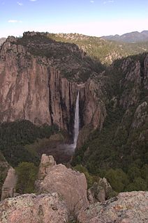
WBasaseachic Falls National Park is a national park located in the western side of the state of Chihuahua in the heart of the Sierra Madre Occidental mountain range. The park is named after Basaseachic Falls the second tallest waterfall in Mexico with a height of 246 meters (853 ft). Basaseachic Falls empties into Candameña Canyon which was carved by the Basaseachic River over millions of years. The park is known for its pine-oak forest, rock formations, and scenic views from high cliffs. Cliffs in the park reach an impressive height of 1,640 meters (5,380 ft).
 W
WThe Benito Juárez National Park is in the Valles Centrales Region of Oaxaca, Mexico, and includes parts of the municipalities of San Felipe Tejalapam and San Andres Huayapan. The southern boundary of the park is about 5 kilometers north of the City of Oaxaca. The park was established in 1937 during the presidency of General Lazaro Cardenas del Rio, and is named after President Benito Juárez, who was a native of Oaxaca.
 W
WCabo Pulmo National Park is a national marine park on the east coast of Mexico's Baja California Peninsula, spanning the distance between Pulmo Point and Los Frailes Cape, approximately 100 kilometres (62 mi) north of Cabo San Lucas in the Gulf of California. Bahía Pulmo is home to the oldest of only three coral reefs on the west coast of North America. Estimated to be 20,000 years old, it is the northernmost coral reef in the eastern Pacific Ocean.
 W
WCerro de la Estrella National Park is centered on the Cerro de la Estrella mountain which is located entirely within eastern Mexico City, in the borough of Iztapalapa.
 W
WThe Cerro de las Campanas is a hill and national park located in Querétaro City, Mexico. It is most noteworthy as the place where Emperor Maximilian of Habsburg and Generals Miguel Miramón and Tomás Mejía were executed, definitively ending the French intervention in Mexico. The mountain gets its name from rocks that, according to legend, make bell sounds when struck.
 W
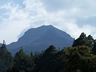
WCofre de Perote, also known by its Nahuatl names Naupa-Tecutépetl and Nauhcampatépetl, both meaning something like "Place of Four Mountain" or "Mountain of the Lord of Four Places", is an inactive volcano located in the Mexican state of Veracruz, at the point where the Trans-Mexican Volcanic Belt, home to all of Mexico's highest peaks, joins the Sierra Madre Oriental. With an elevation of 4,282 metres (14,049 ft) above sea level, Cofre de Perote is Mexico's eighth highest mountain summit.
 W
WConstitution 1857 National Park is located in the pine forests of Sierra de Juárez mountain range in the northern part of Baja California, Mexico. The park is an important preserve for many native wild animals like bighorn sheep and mule deer. The park is characterized by the large variety of coniferous species.
WThe Cumbres de Majalca National Park is a national park in the Mexican state of Chihuahua located 88 km northwest of the city of Chihuahua. The park showcases extraordinary rock formations that have been shaped by wind and water erosion. The park was created by presidential decree in 1939 encompassing 4,772 hectares to protect the endemic flora and fauna. The park is characterized by pine and oak forest. The park is one of the few areas in Mexico that are inhabited by black bear.
 W
WThe Cumbres de Monterrey is a national park of Mexico located in the northern portion of the Sierra Madre Oriental in the states of Nuevo León and Coahuila, near the city of Monterrey. The park protects more than 1,770 square kilometres (680 sq mi) of rugged terrain boasting deep canyons, rivers, waterfalls, and scenic mountain peaks, including the Cerro de la Silla, part of Monterrey's famous skyline.
WCumbres del Ajusco National Park is one of many national parks near Mexico City, DF. The Ajusco is known for its high elevations reaching 3,900 meters (12,795 ft) above sea level and is visible from any part of Mexico city. The park is characterized by pine-oak forests and high mountain grassland. Cumbres del Ajusco means "watered grove peaks", an appropriate name for this mountainous region covered with lush green forest with many flowers due to a fair amount of precipitation. The Balsas and Lerma rivers begin in the heart of the Cumbres del Ajusco.
 W
WDesierto de los Leones National Park is located entirely within the limits of the Federal District; it stretches between Cuajimalpa and Álvaro Obregón boroughs. It is located in the Sierra de las Cruces mountain range west of the city center with an area of 1,867 hectares, representing fifteen percent of the entire Valley of Mexico. The term Desierto (‘desert’) is used in this context in the archaic sense of “wild, sparsely populated area” rather than in reference to an arid environment. Leones (‘Lions’) refers not to the big cats but rather to the original landlord's surname.
 W
WEl Chico National Park is a protected area in the State of Hidalgo, Mexico. It is one of the oldest protected areas in Mexico, as its foundation dates to 1898 when the then president of the republic, General Porfirio Díaz, by decree, created "Monte Vedado del Mineral del Chico". Since this date, the ancient conifer forests have been protected from the deforestation suffered in other parts of the country. Another decree followed in 1915 and still another by Presidential Agreement on 13 September 1922, which declared Monte Vedado to be cataloged as a forest reservation.
 W
WEl Tepeyac National Park is one of a number of federally recognized national parks in Mexico that are protected natural areas and administered by the federal National Commission of Protected Natural Areas (CONANP), a subsidiary of SEMARNAT. It is one of the few green areas located north of the Mexico City suburbs. 95% of its territory is located in Gustavo A. Madero, D.F. Borough and 5% in the municipality of Tlalnepantla de Baz.
WThe Grutas de Cacahuamilpa National Park in Guerrero, Mexico, is best known for the Grutas de Cacahuamilpa Caverns, which are one of the largest cave systems in the world. It is also home to the Grutas of Carlos Pacheco, a smaller system, as well as two subterranean rivers which have carved out tunnels in the rock. The park has outdoor pursuit attractions such as rappelling, and rock climbing in Limontitla Canyon. as well as the two underground rivers to explore. It also has a small botanical garden, a pool and places to camp.
 W
WHuatulco National Park, also known as Bahias de Huatulco National Park is a national park of Oaxaca, Mexico. It was initially declared a protected area and later decreed as a National Park on July 24, 1998. Located in the Municipality of Santa María Huatulco, to the west of Cruz Huatulco, it extends to an area of 11,890 ha. In the low lands of the park, there are 9,000 species of plants in the forest and mangroves in the coastal belt. Fauna species have been identified as 264, which includes armadillos and white-tailed deer. Bird species are counted at 701, which include hummingbirds, pelicans and hawks. The reptile species are counted to be 470, which include Black Iguana, salamanders and snakes. Dolphins, whales and turtles are sighted species off the coast line, out of the identified 100 amphibian species. Vegetation is dominated by the low forest growth of caducifolia in 80% of the area with the unusual feature of 50 ft (15 m) high trees.
 W
WIsla Contoy is a small island in the Mexican state of Quintana Roo, approximately 30 kilometers north of Isla Mujeres. The island is only 8.5 km (5.3 mi) in length and has an area of 3.17 square kilometres (1.22 sq mi).
 W
WThe Marieta Islands are a group of small uninhabited islands a few miles off the coast of the state of Nayarit, Mexico, located in federal waters approximately 7.9 kilometres (4.9 mi) southwest of the peninsula known as Punta de Mita, in the municipality of Bahía de Banderas.
 W
WIzta-Popo Zoquiapan National Park is a national park in Mexico on the border of the states of México, Puebla, and Morelos. The park protects 39,819.08 hectares, surrounding Mexico's second- and third-highest peaks, the Popocatépetl and Iztaccíhuatl volcanoes as well as the area of the Hacienda de Zoquiapán, and its annexed areas (anexas) of Zoquiapan, Ixtlahuacán, and the Frío de Juárez River.
 W
WLa Malinche National Park is located in the states of Puebla and Tlaxcala in Central Mexico. The park is east of Mexico City, and about 44 kilometres (27 mi) from the capital city of Tlaxcala, Tlaxcala.
 W
WLa Marquesa National Park, with the official name Parque Nacional Insurgente Miguel Hidalgo y Costilla, is a National park in the State of Mexico, in central Mexico.
 W
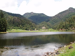
WLago de Camécuaro National Park is located east of the city of Zamora de Hidalgo in the municipality of Tangancícuaro in the state of Michoacán. The Park consists of 9.65 hectares of protected area including Camécuaro Lake which is supplied by a series of natural springs. The lake is popular due to crystal clear water and the beautiful vegetation that surrounds the lake. Even though the lake is relatively small, many photographers from all over Mexico come to take professional photographs that capture the parks picturesque views.
 W
WThe Lagunas de Chacahua National Park, created in 1937, is a national park located in the Municipality of Villa de Tututepec de Melchor Ocampo in the Mexican state of Oaxaca, about 54 km west of Puerto Escondido, near a village called Zapotalito. It can be reached via Federal Highway 200 or by boat from Puerto Escondido. It is located between the towns of Santiago Jamiltepec and Puerto Escondido. The park encompasses 132.73 square kilometres, about 30 km² of which is taken by various lagoons such as the ‘’’Laguna de Chacahua,’’’ ‘’’Laguna de La Pastoria,’’’ and Laguna Las Salinas. There are various smaller lagoons that are connected by narrow channels. The rest of the park consists of dry land.
 W
WLagunas de Montebello, or Montebello Lakes, is a national park in the Mexican state of Chiapas, near the border with Guatemala, comprising 59 multi-colored lakes in a pine forest and two Maya ruins. It was the first national park in Chiapas when created in 1959, and in 2009 the park was designated a Biosphere Reserve by UNESCO.
 W
WLagunas de Zempoala National Park is a natural protected area which consists of a group of seven lagoons. In the Nahuatl language, "Zempoala" means "place of many waters." The park is located between the states of Morelos and State of Mexico, Mexico.
WLos Remedios National Park is a national park in Mexico, located in the far west of the municipality of Naucalpan in Mexico State, just northwest of Mexico City. The park was established by federal decree in 1938 with an area of 400 hectares. Within its borders is the Sanctuary of the Virgin of Los Remedios, a colonial-era aqueduct and a pre-Hispanic archaeological zone with a Chichimeca temple. All of these are located in and around the mountain called Cerro Moctezuma. The site was an Aztec observatory and is also believed to be where Hernán Cortés and his men rested after fleeing Tenochtitlan.
 W
WMolino de Flores Nezahualcóyotl National Park, located in the Municipality of Texcoco, the State of Mexico, Mexico.
 W
WSan Lorenzo Marine Archipelago National Park is a national park of Mexico located on San Lorenzo Island part of an archipelago in the Gulf of California off the eastern coast of Baja California. The San Lorenzo Archipelago is considered one of the most important ecological areas of the Gulf of California. The Island and surrounding areas are part of a rich ecosystem comprised by a grand variety of flora and marine fauna. This area is protected by the Mexican federal government Norma Oficial Mexicana NOM-059-SEMARNAT-2001 because of its importance as a habitat for several endangered species. The Archipelago is part of the municipality of Mexicali, Baja California. The island is located southeast of the city separated by the Salsipuedes Channel.
 W
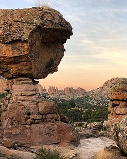
WSierra de Órganos National Park is a national park in Mexico, located in the northwest corner of the municipality of Sombrerete in the state of Zacatecas, near the border with Durango. The park is known for its diverse aridland ecosystem and towering rock formations of the Sierra Madre Occidental, which are reminiscent of organ pipe cacti or the pipes of the musical instrument, from which the park takes its name.
 W
WSierra de San Pedro Mártir National Park is a national park in the Mexican state of Baja California. The Park is part of the municipality of Ensenada, Baja California. The area was first explored by Europeans in 1701 by Eusebio Francisco Kino by Dominican orders.
 W
WSumidero Canyon is a deep natural canyon located just north of the city of Chiapa de Corzo in the state of Chiapas, in southern Mexico. The canyon's creation began around the same time as the Grand Canyon in the U.S. state of Arizona, by a crack in the area's crust and subsequent erosion by the Grijalva River, which still runs through it. Sumidero Canyon has vertical walls which reach as high as 1,000 metres (3,300 ft), with the river turning up to 90 degrees during the 13-kilometre (8.1 mi) length of the narrow passage.
 W
WTulum is the site of a pre-Columbian Mayan walled city which served as a major port for Coba, in the Mexican state of Quintana Roo. The ruins are situated on 12-meter (39 ft) tall cliffs along the east coast of the Yucatán Peninsula on the Caribbean Sea in the state of Quintana Roo, Mexico. Tulum was one of the last cities built and inhabited by the Maya; it was at its height between the 13th and 15th centuries and managed to survive about 70 years after the Spanish began occupying Mexico. Old World diseases brought by the Spanish settlers appear to have resulted in very high fatalities, disrupting the society, and eventually causing the city to be abandoned. One of the best-preserved coastal Maya sites, Tulum is today a popular site for tourists.